WELCOME TO STROAT.
If YOU have ANY information on the village of Stroat
PLEASE contact the blog owner as soon as possible
for it to be added.

.

DO MAKE USE of LINKS,
>SEARCH<
&
>Side Bars<
&
The Top Bar >PAGES<

~~~~~~~~~~#########~~~~~~~~~~

.
Carolyn Black – “Exploring Landscapes” Panoramic Views On Both Banks of The Severn Including Stroat …
.
~~~~~~~~~~#########~~~~~~~~~~

Posted by:
Greg Lance – Watkins
Greg_L-W

eMail:
Greg_L-W@BTconnect.com

STROAT WIND TURBINE WEB SITE
https://wordpress.com/post/stroatwindturbine.com/390

The BLOG:
https://InfoWebSiteUK.wordpress.com

The Main Web Site:
www.InfoWebSite.UK

~~~~~~~~~~#########~~~~~~~~~~

.

Hi,

.

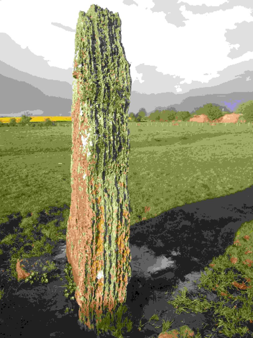
the standing stone ajoining the rail line in Stroat:

The Wibdon / Stroat Broad Stone
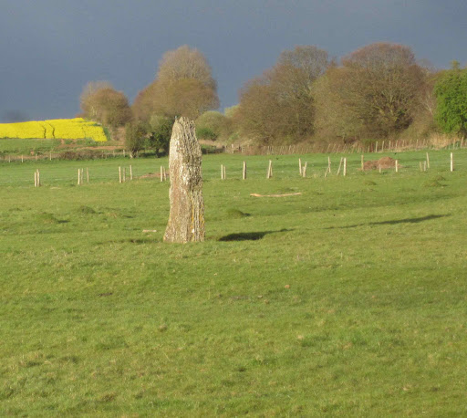
Photo: by Lee Lance – Watkins Aug-2012

Below is part of a digital photo of an original panoramic view, with the bridge under the rail line showing THE STANDING STONE on STROAT FARM LAND executed in Charcoal, chalk, pastels, watercolour & ink by Carolyn Black.

Carolyn Black – exploring landscapes

“What a fascinating and enriching exploration. The glimpse of your drawings makes me want to draw. Your text makes me want to walk to a river. The panoramic horizon makes me want to think far deeper and further than ordinarily.” Anthea Nicholson, author


EXHIBITIONS

File 22-06-2017, 06 28 48

File 22-06-2017, 06 28 04

Newnham Church

IMG_8389

IMG_8393

newnham ferry 18th may

fullsizeoutput_67b

fullsizeoutput_679.jpeg

fullsizeoutput_67a

purton railway import

perfect-trimmed-river-001-img_0016-for-web

I’m working on new drawings constantly, mostly depicting places either side of the River Severn in Gloucestershire. Read about the historical context of how these works have evolved, over some 20 years, here. These are black & white photos of original works and, as such, are different to the actual drawings. To view them larger, click on images and they will open a new page. To gain a sense of scale, go here. They all measure approximately 75cm x 25cm.

The images shown are photos of the original work where stated (mostly in frames or in context). They have a wider tonal range and are more subtle than black and white digital. Due to the large scale of the originals, they are better represented in this way. Others are black & white digital prints, photographs of the original artworks modified for editioning, not the actual artworks.

Close ups, showing detail:

I’m delighted to say I have been awarded a Grants for the Arts to pursue the next stage – a publication – about the drawings, the River Severn and this fascinating landscape.

Print

It may well prove of interested to read in a similar vein of The Oldbury Standing Stone, on the other side of the Severn Estuary, sometime called the Thornbury Stone, which would seem to have been lost to the community since 1953.

<< Our Photo Pages >> Oldbury Standing Stone – Standing Stone (Menhir) in England in Gloucestershire

Submitted by theCaptain on Thursday, 26 September 2019  Page Views: 5742
Neolithic and Bronze AgeSite Name: Oldbury Standing Stone
Country: England County: Gloucestershire Type: Standing Stone (Menhir)
Nearest Town: Thornbury  Nearest Village: Oldbury-on-Severn
Map Ref: ST61169234
Latitude: 51.628524N  Longitude: 2.562514W
Condition: 2 Ambience: 3 Access: 4 Accuracy: 4

Internal Links: 
External Links: 

Contribute! (tap for more)


This site has 1 log from visitors (tap for more)

This site has 5 comments or news updates (tap for more)

Oldbury Standing StoneOldbury Standing Stone submitted by christymko

The Oldbury Standing Stone was thought to have been lost, if not destroyed, but investigations by christymko have uncovered this 11 foot long beauty. See comments for details.

Position of a once 8ft tall standing stone, last recorded in 1953 as being used as a stone crossing of one of the tributary streams into the Oldbury Naite Rhine (pronounced Reen), to the east of the Anchor Pub.

So, on a warm sunny afternoon, I went for a good look, but found nothing to match the description. In fact, at some time in the past (since 1953) a whole load of drainage, seawall flood protection work has been done, which now contains the Oldbury Naite Rhine within substantial banks, with any of its little tributaries in the area now in underground culverts emptying through flap doors into the Rhine. The height of the banking is now well above what it would have been.

In a couple of places, away from the modern banks, it is possible to make out what might once have been tributary ditches, but these are now well hidden withn hedges, and all trackways have large new concrete bridges over anything that may get wet. Perhaps somewhere underneath it all is the old stone, or perhaps it has been broken up and now used at the edges of the roads to stop people parking on the verges. Certainly, I dont think there is anything left to be seen.

From Pastscape: ” ST 61169234. A large stone, formerly erect, 8 ft long, 1 ft broad and 2 ft thick, now lies across a small stream feeding Oldbury Naite Rhine.” (E K Tratman 14 11 1953)

Note: The Oldbury Standing Stone was thought to have been lost, if not destroyed, but investigations by christymko have uncovered this 11 foot long beauty. See comments for details.
You may be viewing yesterday’s version of this page. To see the most up to date information please register for a free account.

Oldbury Standing StoneOldbury Standing Stone submitted by christymko
The Oldbury Standing Stone was thought to have been lost, if not destroyed, but investigations by christymko have uncovered this 11 foot long beauty. “I was told many years ago by Mary Bruton, an eccentric and highly intelligent artistic lady who was born in Oldbury that it had been laid flat and used as a hard surface under the stile next to the bridge over the Rhine at Priest’s Gout. I edi…
Oldbury Standing StoneOldbury Standing Stone submitted by TheCaptain
I went for a look for this stone on a hot sunny June afternoon as part of a walk around Oldbury. Despite being 99% sure where it was to be found, I initially didn’t find it as it was totally overgrown, and not under the new footpath gate, but an old wooden bit of fence to the side. With a bit of trampling on the long grass, I got to see the whole stone. Great to see it, it would be a splendid stan…
Oldbury Standing StoneOldbury Standing Stone submitted by TheCaptain
On a warm sunny afternoon, I went for a good look for this, but found nothing to match the description. In fact, at some time in the past (since 1953) a whole load of drainage and seawall flood protection work has been done, which now contains the Oldbury Naite Rhine within substantial banks, with any of its little tributaries in the area now in underground culverts emptying through flap doors int…
Do not use the above information on other web sites or publications without permission of the contributor.

Nearby sites

Click here to view sites on an interactive OS map

Download to GPS/SatNav (tap for more)

Nearby sites listing. In the following links * = Image available
365m N 350° The Toots (Oldbury)* Hillfort (ST611927)
541m SW 217° St Arilda’s, Oldbury-on-Severn* Artificial Mound (ST60839191)
2.1km SSE 163° St Arilds Well* Holy Well or Sacred Spring (ST61759030)
2.4km NNW 327° Oldbury-on-Severn Submerged Forest* Natural Stone / Erratic / Other Natural Feature (ST59849440)
4.0km S 185° Elberton Camp* Hillfort (ST60808840)
4.3km SSE 160° Alveston Round Barrow* Round Barrow(s) (ST62608831)
4.5km E 85° Camp Hill (Rockhampton)* Hillfort (ST657927)
4.7km ENE 72° Rockhampton Standing Stone* Marker Stone (ST65679378)
5.3km SE 133° Abbey Camp* Hillfort (ST65008870)
5.6km SSE 157° Fishmonger’s Swallet Cave or Rock Shelter (ST63318720)
5.7km S 188° Miles Well* Holy Well or Sacred Spring (ST6036486654)
6.0km NW 325° Broad Stone (Gloucestershire)* Standing Stone (Menhir) (ST5776397247)
6.1km S 182° Rams Well* Holy Well or Sacred Spring (ST6085186266)
6.3km NE 43° Blisbury Hill Camp* Hillfort (ST65569692)
6.6km SE 127° Tytherington Camp* Promontory Fort / Cliff Castle (ST66438834)
6.7km WSW 249° St Tecla’s Chapel & Holy Well Holy Well or Sacred Spring (ST5484390020)
7.2km W 265° Thornwell Round Barrow* Round Barrow(s) (ST540918)
7.2km W 264° Thornwell Farm* Chambered Tomb (ST53959167)
7.2km W 272° St Peter’s Cave Cave or Rock Shelter (ST539927)
7.4km W 273° The Bulwarks (Monmouthshire)* Hillfort (ST53789274)
7.8km E 96° Bloody Acre Camp* Hillfort (ST689915)
7.8km WNW 283° Chepstow Museum* Museum (ST53579420)
8.2km WNW 302° Spital Meend* Promontory Fort / Cliff Castle (ST54269671)
8.4km WNW 295° Pierce Wood Camp 1* Hillfort (ST53619596)
8.4km NW 311° Offa’s Dyke at Tidenham Chase* Misc. Earthwork (ST548979)
<< Vinstra Helleristninger

Kånna Högar >>

Please add your thoughts on this site

“Oldbury Standing Stone” | Login/Create an Account | 5 News and Comments
Newest First
Oldest First
 
  
Go back to top of page    Comments are owned by the poster. We aren’t responsible for their content.

Re: Oldbury Standing Stone (Score: 1)
by stonetramp on Friday, 27 September 2019
(User Info | Send a Message)
Ah, now I see it in the comments.
Reply to This ]

Re: Oldbury Standing Stone (Score: 1)
by stonetramp on Friday, 27 September 2019
(User Info | Send a Message)
Wonderful that this stone was found, but why is there no story about how he found it?
Reply to This ]

Re: Oldbury Standing Stone (Score: 1)
by johndhunter on Friday, 27 September 2019
(User Info | Send a Message)
This is fascinating, is is known where it might have stood when erect , old OS maps don’t indicate any stones in the Priest’s Gout area, so it was probably already being used as a bridge before the first mapping took place.
Reply to This ]

Re: Oldbury Standing Stone (Score: 0)
by Anonymous on Wednesday, 25 September 2019
Hi,
I’m really excited to have randomly found your site as I know the location of the lost standing stone at Oldbury-on-Severn which I was really surprised to see mentioned.

I was told many years ago by Mary Bruton, an eccentric and highly intelligent artistic lady who was born in Oldbury that it had been laid flat and used as a hard surface under the stile next to the bridge over the Rhine at Priest’s Gout. I edit the local community magazine ‘4ward’ and by chance there have been a couple of references lately to Priest’s Gout – the name of the old bridge over the Rhine so I before writing a little article about the stone I checked if it was still there and was amazed to see it just visible underneath debris under the old footpath gate ( recently replaced with a brand new kissing gate off to the side ) . Well , I mentioned this in the local pub last night and today a builder friend of mine went to take a look .

He did more than look , he took dimensions – the stone is 11 feet long, 22 inches broad and 10 inches deep so quite a stone! The first thing my builder friend said was it looked like a bridge so I was fascinated to read on your site that it was in fact used as a bridge , probably for centuries. Could that have been its purpose all along ?
Christabelle

Reply to This ]

Re: Oldbury Standing Stone (Score: 1)
by TheCaptain on Wednesday, 25 September 2019
(User Info | Send a Message)
That is excellent. I’ll have to pop out for another look sometime

Reply to This ]

Your Name: Anonymous [ Register Now ]

Subject:

Add your comment or contribution to this page. Spam or offensive posts are deleted immediately, don’t even bother

<<< What is five plus one as a number? (Please type the answer to this question in the little box on the left)
You can also embed videos and other things. For Youtube please copy and paste the ’embed code’.
For Google Street View please include Street View in the text.
Create a web link like this: <a href=”https://www.megalithic.co.uk”>This is a link</a>

Allowed HTML is:
<p> <b> <i> <a> <img> <em> <br> <strong> <blockquote> <tt> <li> <ol> <ul> <object> <param> <embed> <iframe>
 
 We would like to know more about this location. Please feel free to add a brief description and any relevant information in your own language.
 Wir möchten mehr über diese Stätte erfahren. Bitte zögern Sie nicht, eine kurze Beschreibung und relevante Informationen in Deutsch hinzuzufügen.
 Nous aimerions en savoir encore un peu sur les lieux. S’il vous plaît n’hesitez pas à ajouter une courte description et tous les renseignements pertinents dans votre propre langue.
 Quisieramos informarnos un poco más de las lugares. No dude en añadir una breve descripción y otros datos relevantes en su propio idioma.

Please do not use this site if you do not agree to our Terms and Conditions of use.
If you plan to visit ancient sites in person, please make sure you follow our Charter.

What’s New Browse by Country Add a new Site Join our Society New in the Shop About Us
Feature Articles Browse by Site Type Your own page email Newsletter Follow us on Twitter Terms and Conditions
Book Reviews Accessible Sites Your visit log Google Earth Be a Facebook friend Contact Editor
Latest Photos Top Rated Sites Submit News / Article Google Street View Downloads and ebooks Site Privacy Policy
 Main News  Forum Latest  New Images Find nearby sites Search Page Main News


Switch to the Standard (non Mobile) version of the Megalithic Portal

Articles, photographs and comments are the property of their respective authors or contributors, please contact them for permission to reproduce. Site design © Andy Burnham.

To view the original Oldbury Standing Stone Site CLICK HERE

Regards,
Greg_L-W.

~~~~~~~~~~#########~~~~~~~~~~
.
Posted by: Greg Lance-Watkins
tel: 44 (0)1594 – 528 337
Calls from ‘Number Withheld’ phones Are Blocked

All unanswered messages are recorded.
Leave your name & a UK land line number & I will return your call.

‘e’Mail Address: Greg_L-W@BTconnect.com

Skype: GregL-W

TWITTER: @Greg_LW

DO MAKE USE of LINKS,
>SEARCH<
&
>Side Bars<
&
The Top Bar >PAGES<
I try to make every effort to NOT infringe copyrights in any commercial way & make all corrections of fact brought to my attention by an identifiable individual
.

Please Be Sure To
.Follow Greg_LW on Twitter.

Re-TWEET my Twitterings
https://twitter.com/Greg_LW

& Publicise

My MainWebSite & Blogs

To Spread The Facts World Wide


eMail:
Greg_L-W@BTconnect.com

The BLOG:
https://InfoWebSiteUK.wordpress.com

The Main Web Site:
www.InfoWebSite.UK

~~~~~~~~~~#########~~~~~~~~~~

Advertisement