TIDENHAM INCLUDING
LANCAUT & STROAT etc.
Topics
INTRODUCTION
MANORS & OTHER ESTATES
ECONOMIC HISTORY
LOCAL GOVERNMENT
CHURCHES
NONCONFORMITY
EDUCATION
CHARITIES
+
Tidenham Chase families 1850 to date
Material on this blog has been gathered from material which is readily available in the public domain or has been generously provided by both named & un-named individuals.
Images used on the web site will be published with attribution to the lender/owner or anonymously if you so wish.
We have moved here from CLICK HEREfor various reasons but have left a full archive there and a forwarding link to this site. There may be a problem for a while as LINKS are updated as they may take you to the old site! (NOT a risk or problem but I hope it does not inconvenience you).We hope you find the information of help and hope if you are aware of facts we have missed out that you will consider sending the details to the blog for inclusion.
Although the site is about Stroat we also include information of general interest relative to The Forest of Dean sourced, in the main, via Google Alerts & Google searches.Thank you to all who have helped so far.
TIDENHAM INCLUDING
LANCAUT & STROAT etc.
Topics
INTRODUCTION
MANORS & OTHER ESTATES
ECONOMIC HISTORY
LOCAL GOVERNMENT
CHURCHES
NONCONFORMITY
EDUCATION
CHARITIES
+
Tidenham Chase families 1850 to date
Introduction
Introduction
Sponsor
Victoria County History
Publication
A History of the County of Gloucester: Volume 10: Westbury and Whitstone Hundreds
Author
C R Elrington, N M Herbert, R B Pugh (Editors), Kathleen Morgan, Brian S Smith
Year published
1972
Supporting documents
Note on abbreviations
Pages
50-62Show another format:’Tidenham including Lancaut: Introduction’, A History of the County of Gloucester: Volume 10: Westbury and Whitstone Hundreds (1972), pp. 50-62. URL: http://www.british-history.ac.uk/report.aspx?compid=15757 Date accessed: 22 October 2014.
Highlight
(Min 3 characters)
Contents
TIDENHAM INCLUDING LANCAUT
Footnotes
TIDENHAM INCLUDING LANCAUT
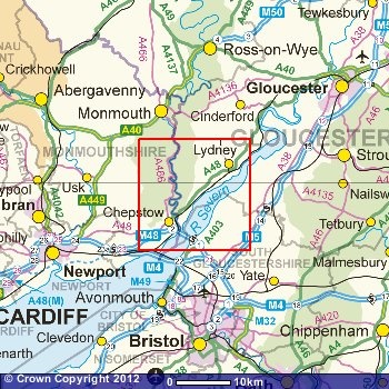
TIDENHAM lies on the boundary of Gloucestershire and Monmouthshire to the east of Chepstow. The parish forms a roughly wedge-shaped area between the broad estuary of the Severn on the east and the meandering course of the Wye on the west, tapering towards the south into a narrow peninsula at the confluence of the two rivers. Crossing points of the rivers, notably the Severn passage at Beachley, played an important part in the development of settlement, and fisheries were a major factor in the economy of Tidenham from late Saxon times when it was a large royal manor. Tidenham later became part of the Marcher lordship of Striguil whose lords created a hunting chase in the manor.
Offa’s Dyke, once marking the boundary between the lands of the English and Welsh, runs down the western side of the parish but excludes two areas, the peninsula of Lancaut formed by a meander of the Wye, and the Beachley peninsula on the south. Lancaut evidently remained in Welsh occupation in the 8th century when the dyke was built, but by 956 it was part of the English king’s manor of Tidenham. (fn. 1) Nevertheless it retained its separate identity within the manor; (fn. 2) in the Middle Ages it was a separate ecclesiastical parish, (fn. 3) and in the later 19th century it was accorded the status of a civil parish, amounting to 218 a., being merged in Tidenham parish in 1935. (fn. 4) Beachley was also part of Tidenham manor by 956 and was apparently the area described in a Saxon survey of the manor made then or later as lying ‘outside the inclosed land’ and let in part to Welsh sailors; (fn. 5) it has been suggested that the small seaport existed at the time of the building of the dyke and was excluded by it in order to leave both sides of the mouth of the Wye, and the Severn crossing at Beachley, under Welsh control. (fn. 6) In 956 the bounds of Tidenham manor followed the Severn on the east and the Wye on the west while the northern and north-eastern boundary between the two rivers followed a series of landmarks some of which can be identified. (fn. 7) The boundary began at Yewtree Headland, the neck of land on the Wye opposite Tintern where the woods still contained many yews in 1969, ran on to the Stone Row, and then to White Hollow (Hwitan Heal), a name which survives in Whitewalls, a house east of Oakhill Wood; (fn. 8) it then passed through Yew Valley, Broad Moor, and Twyford, where the Piccadilly and Black brooks join at the main Gloucester-Chepstow road, (fn. 9) and came to a pill on the Severn later called Horse Pill. (fn. 10) Those bounds took no account of Madgett, an area of 311 a. lying within the northern boundary of the parish. (fn. 11) In 956 Madgett was probably already detached from Tidenham manor, for the manor was extended at 30 hides (fn. 12) as it was in 1066 when Madgett was certainly no longer part of it, being held with one of the Woolaston manors; (fn. 13) Madgett remained part of Woolaston parish until 1882 when it was merged with Tidenham. (fn. 14) The original boundary on the north-east presumably ran from Park Hill through Mereway Grove and down the Piccadilly brook to Twyford, but later an irregular arm of Woolaston parish extended into Tidenham as far as Ashwell Grange and a small detached piece of Tidenham survived within that arm near Ashwell Grove. (fn. 15) The irregular boundary appears to have resulted from allotments of tithes to the respective parishes at the inclosure by Tintern Abbey of the Ashwell Grange estate from the waste in the early Middle Ages; (fn. 16) much of the 119 a. of assarts made by the abbey in Tidenham before 1282 (fn. 17) probably lay in that area. The detached piece of Tidenham was merged with Woolaston in 1882, (fn. 18) and the boundary in that area was rationalized in 1935 when 113 a. of Tidenham between Ashwell Grange and the Piccadilly brook were transferred to Woolaston. (fn. 19) The account given here relates to Tidenham parish as it existed before the boundary changes (an area of 6,065 a., excluding river foreshore) (fn. 20) and to Lancaut; the history of Madgett is given under Woolaston.
The east and south parts of the parish are lowlying, mainly at under 100 ft., and the land is formed chiefly by the Keuper Marl. East of Sedbury, however, the Lower Lias overlying the Rhaetic beds forms an area of higher ground terminating in Sedbury Cliffs (fn. 21) which rise to c. 150 ft. above the Severn. North of Pill House a stretch of flat meadow land bordering the Severn is formed by alluvial deposits. (fn. 22) Sea-walls to defend that part against the river were being maintained in the late 13th century, (fn. 23) but in 1969 they were no longer kept up and survived only in short stretches, for in recent years a considerable area of land had been gained from the river and planted with grass; the river’s action has also added land to the bank further south, in Beachley Bay. (fn. 24) In the late 17th and early 18th centuries the Tidenham manor court was concerned with the upkeep of sea-walls along the Wye on the west side of the Beachley peninsula. (fn. 25) To the northwest of the main Gloucester-Chepstow road the land rises steeply to c. 550 ft. before levelling off to form a wide plateau; on the west side the land falls even more steeply to the Wye, in places forming bare rock cliffs at 200-300 ft. above the wooded banks of the river. In the north-western part the land is formed mainly by the Carboniferous Limestone, although a strip of the Old Red Sandstone intervenes on the hill slopes to the east, and there are two considerable areas of Millstone Grit on the northern plateau and patches of Dolomitic Conglomerate on the west. (fn. 26) In 1292 the reeve of the manor sold 316½ horse-loads of coal from Tidenham Chase in the north of the parish; (fn. 27) the tenants reported that coals could be found on the chase in 1584, (fn. 28) and the lord of the manor was negotiating with miners for the exploitation of the deposits there in 1677. (fn. 29) The limestone of the parish has been extensively quarried both for local building purposes and for export from the parish. (fn. 30)
The whole parish of Tidenham lay at one time within the Forest of Dean, but by the early 13th century the lords of the manor had appropriated a great hunting chase extending across both Tidenham and Woolaston, and the exclusion of the two parishes from the jurisdiction of the forest had been established by the end of the century. The earliest record found of Tidenham Chase was in 1228 when it was said to have existed from antiquity, (fn. 31) but other jurors in the 13th century attributed its creation to William Marshal (d. 1219). (fn. 32) In the 1270s the chase was said to stretch from Chepstow Bridge to the Cone brook on the Woolaston- Alvington boundary; on the north it was presumably confined by the original Woolaston-Hewelsfield boundary, for the lord of Tidenham was reported to have extended its bounds into Hewelsfield during Henry III’s reign. (fn. 33) The jurors perambulating the Forest of Dean in 1228 regarded the chase as still being part of the forest, as did those of 1282 who gave the confluence of Severn and Wye as the forest’s southern boundary; (fn. 34) in 1267, however, the Cone brook had been stated to form the boundary between the forest and the Earl of Norfolk’s lordship. (fn. 35) The distinction was made again in other evidence given in 1282, when it was complained that the earl’s riding forester in the chase and others were accustomed to make poaching expeditions into the forest and then return to the chase where they could not be attached because it lay outside the county. (fn. 36) The exclusion of Tidenham and Woolaston from the forest was confirmed by a perambulation of 1300. (fn. 37)
The creation of the chase meant that the greater part of the parish lying north-west of the main Gloucester-Chepstow road long remained woodland and waste. Considerable encroachment on that area had evidently taken place by 1282 when various people were reported to have assarted in recent years a total of 267 a. in Tidenham, all of it being used for tillage, (fn. 38) but the available evidence suggests that at that period the open-field arable was still mainly concentrated south-east of the main road close to the Severn. By the end of the 16th century, when presumably further clearance had taken place, the open fields were mainly in the central area of the parish on the hill slopes north-east of the road. (fn. 39) A wood two leagues long and half a league wide was recorded in the parish in 1066, (fn. 40) and the thick woodlands bordering the Wye in the north-west and those on the northern boundary are evidently an ancient feature of the landscape. They were apparently once within the chase, for in 1584 the tenants of Tidenham manor complained that East Wood, Oakhill Wood, Cowshill Wood (apparently that west of Oakhill Wood), Caswell Wood, Shorn Cliff, Plumweir Cliff (later Plumweir Grove), Wallweir Wood (later the Slade), Dymwall (possibly Dennelhill) Wood, and Studdlepoll (perhaps Stowl Grove which lay east of Woodcroft) had all like the chase once been common to them, but the greater part had since been inclosed by the lord of the manor; most of the inclosure complained of had apparently taken place in the previous ten years. In 1769 the whole stretch of woods from Dennelhill round to East Wood, a total of c. 730 a., belonged in severalty to the lord of the manor. (fn. 41) At least one large wood remained within the chase, however: it was described c. 1775 as the common wood of 128 a. extending from Wallweir Wood to Madgett, and it evidently included High Wood. (fn. 42) There was probably also at one time a continuous belt of woodland on the hill slopes east of the chase: by the early 19th century as in 1969 that area had only scattered copses, but a number of the intervening fields had names which contained ‘redding’, denoting a clearing, while the field-names Rudgeley, Kinley, Dunley, and Mopley occurred further south-west. (fn. 43) Chapelhouse Wood (then 34 a.) bordering the Wye near Tutshill and Coombesbury Wood (15 a.) near the church also belonged to the Tidenham manor estate in 1769, (fn. 44) and there was considerable woodland further south in Sedbury tithing; in 1770 the Mead estate had 77 a. of woodland bordering the Severn there, including Millfield Grove, Cumberland Wood, and Baker’s Wood, (fn. 45) and another 50 a. or more, most of it in Great Grove north of Offa’s Dyke, was included in Sedbury Park at its creation in 1797. (fn. 46)
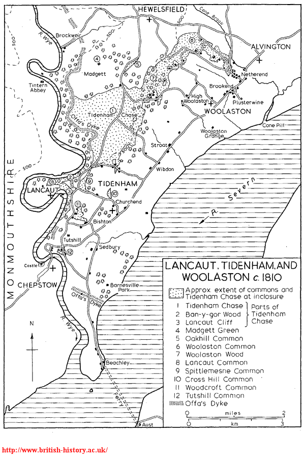
Lancaut, Tidenham and Woolaston c. 1810
Figure 4: Lancaut, Tidenham and Woolaston c. 1810
By 1810 Tidenham Chase was virtually confined to the high northern plateau of the parish and covered c. 1,000 a.: its eastern boundary roughly followed the 450 ft. contour (although a number of small encroachments lay within its limits), while it was bounded on the south by Boughspring, on the west by Offa’s Dyke, and on the north by the Madgett inclosures. Two detached areas, Ban-y-Gor Rocks and Lancaut Cliff, extending along the Wye respectively north and south of the Lancaut peninsula, were still regarded as part of the chase, and there were other considerable areas of waste near-by in the commons of Lancaut, Spittlemesne, and Woodcroft. The chase and the smaller commons, with Woolaston Common (evidently the remnant of the chase in that parish), a total of 1,600 a., were inclosed in 1815; by that time the open fields of Tidenham had all been inclosed by private agreement. (fn. 47) Some parts of the former chase, on the Chase Farm estate to the west, had been turned to arable by 1832, but in 1969 the portion that was farmed, like almost all the remainder of the parish, was pasture. Other parts of the chase have been used for plantations: 95 a. of the Chase Farm estate, including High Wood and Ash Grove, were planted or replanted c. 1825, (fn. 48) and in 1929 the Forestry Commission acquired Parson’s Allotment and planted it with pines. (fn. 49) In 1969, however, one part, the Poor’s Allotment to the east, still remained a common covered with bracken and gorse, a reminder of the former appearance of much of the north part of Tidenham parish.
Besides the chase the medieval lords of the manor had a park at Tidenham. It lay south of Tidenham village adjoining the main road on the north-west, and in the late 13th century it extended as far eastwards as the Severn. (fn. 50) It was evidently well timbered in the 1290s when bark -in one year 50 horse-loads – and wood from it were sold; (fn. 51) it may have included Park Grove on the south, which belonged to the lord of the manor in 1769. (fn. 52) The provision of new palings around the park and repairs to a building at its gateway were items of its maintenance in the late 13th century. (fn. 53) There was a parker to keep the park by 1280, (fn. 54) and in 1306, when the park contained wild beasts, he held ½ yardland by that service. (fn. 55) By 1584 the park had been divided into several parcels and was apparently leased for agriculture. (fn. 56)
The strategic position of the parish at the crossingpoints of Wye and Severn of important routes between England and Wales has left it fairly rich in ancient remains. Offa’s Dyke is the major archaeological monument. In the northern part of its course through Tidenham, following the contours on the crest of the steep slopes above the Wye, it is a substantial continuous structure with a height of over 20 ft. on the river side. At the angle of a turn in the dyke is a short pillar of rock which was known as the Devil’s Pulpit by 1769. (fn. 57) South of Dennelhill Wood the dyke survives only in broken and much less well-defined stretches; in some places it may have been destroyed by quarrying while in others the steep cliffs were perhaps thought to be sufficient boundary. An earlier promontory fort facing eastwards and stretching from one steep cliff edge to the other was adopted as the course of the dyke across the neck of the Lancaut peninsula. At its southern end the dyke cuts across the Beachley peninsula from Tallard’s Marsh on the west, where it incorporates a small defensive work apparently made to guard a landing-place, to Sedbury Cliffs on the east; the most substantial portion of that stretch is Buttington Tump at the point where the road to Beachley cuts the dyke. (fn. 58) Several other earthworks have been identified on the hill slopes in the centre of the parish. There is a camp in Coombesbury Wood by Tidenham church and a smaller earthwork, possibly the site of an early manor-house, lies north of it. (fn. 59) The remains of another small camp lie at a place called Dinnegar just within the parish boundary south of Ashwell Grange. (fn. 60) An Iron Age fort gave its name to Oldbury field east of Garston, but its remains were mostly ploughed out in the mid 19th century. (fn. 61) Excavation at a tumulus on Tidenham Chase south of Chase Farm has revealed traces of Mesolithic and Early Bronze Age occupation. (fn. 62) A prehistoric trackway passing close to the last three sites has been traced across the parish from the Broad Stone on the Severn, which probably marked the terminal of an ancient passage of the river, to the Wye crossing at Brockweir. (fn. 63) The Broad Stone, so called by 1270, (fn. 64) is an irregularly shaped slab of stone, c. 9 ft. high, set upright in a shallow depression not far from the river bank. From it the trackway apparently ran to Stroat hamlet and then climbed the steep slopes towards the chase on the line of the footpath from Stroat Farm to Rosemary Lane; a line of large stones placed at intervals marks the course of the track for a considerable part of that section. (fn. 65) The track then followed the line of Rosemary Lane up the hill passing close to the site of the modern chapel of ease and then crossed the chase by the existing track to Beech Farm. Where it passed out of the parish on its way down Madgett Hill to Brockweir it may once have been bordered by another row of stones, providing the boundarymark of Tidenham manor in 956, (fn. 66) and the Chase Gate of a 16th-century statement of the bounds was evidently on the same part of the track; that part of the track was recorded as the horse-way from Madgett to Brockweir in 1683. (fn. 67) The Gloucester- Chepstow road crossing the parish was a Roman one, although at Tutshill its line deviated from the present road and took a more northerly course to make a crossing higher up the Wye (fn. 68) at a point where remains, thought to be of an ancient bridge, have been observed. (fn. 69) A Roman altar was found in a mound in Parson’s Allotment in 1825, but excavation of the site in the 1950s revealed only traces of a building occupied at the beginning of the 18th century, and it was concluded that the altar had been brought from elsewhere. (fn. 70) It may have come from a Roman site not far away north of Boughspring which was discovered in the 1960s. (fn. 71) In 1860 George Ormerod, the local antiquary, found Roman pottery and other remains at a site in Sedbury Park, (fn. 72) and Roman coins have been found in Tidenham churchyard. (fn. 73) A monument of a much later date, a tall and narrow stone which was hauled up from the bank of the Severn and erected to commemorate the Jubilee of 1897, stands on the chase at the junction of the rides through the plantation on Parson’s Allotment. (fn. 74)
The passage of the Severn between Aust and Beachley, sometimes called the Old Passage to distinguish it from the New Passage downstream, was probably in use from antiquity and was long the chief route between south-west England and Wales. It was recorded in the earlier 12th century when the de Clares, lords of Tidenham, granted quittance of the passage to the monks of Tintern, (fn. 75) and was evidently much used in 1405 when great numbers of the English and Welsh were said to resort to the near-by chapel of St. Twrog. (fn. 76) The passage was regarded as of considerable strategic importance during the Civil War, (fn. 77) and c. 1775 it was said to be much frequented by travellers between Bristol and South Wales. (fn. 78) The passage, a distance of over a mile at a point where the tides run swiftly, was a dangerous one, and its reputation, the roughness of the water, and the smallness of the passage boats deterred Defoe and his companions from making the crossing from the Aust side early in the 18th century; (fn. 79) in 1839 one of the sailing-boats used at the passage foundered, drowning all its occupants, (fn. 80) and another boat was lost with most of its passengers in 1855. (fn. 81)
The passage, as the grant to Tintern indicates, belonged at one time to the lords of Tidenham manor, who retained rights in it until the 19th century. In 1584 the lord of Tidenham was receiving a ‘port rent’ of 10s. from Aust and 10s. from Beachley for the passage; (fn. 82) in 1704, however, the rents were 11s., paid by the tenants of the passage from the Beachley side and by the lord of Aust manor from the other side. (fn. 83) The rents were still being paid to Tidenham manor by the partners in the ferry company in 1841. (fn. 84) The rent paid from Beachley was presumably in return for a grant of the rights belonging to that side made by the lord of Tidenham to the lord of Beachley manor, for in 1656 all those rights, which were divided into 9 equal shares, belonged to or were held from Beachley manor: 5½ shares were freeholds of the manor and were divided among four owners, 2½ shares were held on lease, and the remaining share was evidently in the lord’s hands; (fn. 85) the Lewis family, lords of Beachley manor, retained its 3½ shares in 1785. (fn. 86) The division of ownership into 9 shares evidently dated from before 1414 when John Crook of Olveston held 1/9 of the passage. That share together with a house at Beachley called Crook’s Place passed in the 1420s to William Philpot, (fn. 87) and was retained by his descendants who had acquired another share by 1592. (fn. 88) The Philpot family sold its two shares to Sir Samuel Astry of Henbury in 1702, (fn. 89) and another share, apparently that owned by Francis Price in 1656, was acquired by the Astry family before 1728. (fn. 90) Those three shares had passed by 1751 to Richard Chester, (fn. 91) whose family retained them in 1783. (fn. 92) Another 1½ shares of the passage were owned by William Higgins in 1656 and by William Higgins and Thomas Hitchings in 1667; (fn. 93) they descended in the Hitchings family until the mid 18th century when they were acquired by Samuel Hill (d. c. 1779). (fn. 94) The remaining 1/9 share was owned by Alexander James in 1656 and evidently descended with his Tidenham estate, being owned by Charles Williams c. 1775. (fn. 95)
An inn at Beachley called the ‘Green Dragon’ belonged to the Philpots in 1651 (fn. 96) and descended with their portion of the passage; by 1728 its name had been changed to the ‘Ostrich’ (fn. 97) and by 1783 it was known as the Beachley passage house. (fn. 98) It stood by the river to the south of Beachley village (fn. 99) where an approach was possible for the boats between two projecting shelves of rock, and c. 1800 it was a large building with a projecting bay at the front standing above a stone embankment which incorporated a short slipway to the water’s edge. (fn. 1) Another inn at Beachley called the ‘George’ also belonged to the Astrys in 1728, (fn. 2) and the two inns with their three shares in the passage and passage boats were leased by the Chesters to Thomas Hitchings in 1751, and to Samuel Hill in 1766 (fn. 3) who by virtue of his possession of half the shares apparently operated the passage. In 1767 Hill advertised that he had provided a movable landing-stage from which horsemen could ride on board the passage boats, and he kept postchaises and a post-coach for hire; travellers on the Aust bank could summon a boat from Beachley by a smoke signal. (fn. 4)
In 1825 a new era opened for the passage with the formation of the Old Passage Ferry Association by James Jenkins of Chepstow, Richard Jenkins of Beachley, and Oliver Chapman of Chepstow. (fn. 5) James Jenkins had presumably succeeded to the ownership of the lord of Beachley’s 3½ shares and also of the passage house which Samuel Jenkins had owned in 1815; (fn. 6) the other owners of the rights on the Beachley side and the owners on the Aust side were presumably bought out. The Duke of Beaufort, lord of Tidenham manor, apparently sponsored the venture. The company built new stone piers on both banks, the Beachley one some way further south than the old landing-place below the passage house, and commissioned a steamboat which began to ply in 1827. (fn. 7) By virtue of those improvements the company achieved the transfer of most of the cross-Severn mail routes from the rival New Passage downstream at St. Pierre, and c. 1830 traffic over the Old Passage was said to have greatly increased with stage-coaches passing through Beachley six times a day. (fn. 8) It apparently did not achieve immediate financial success, however, for in 1830 the Tidenham vestry, in view of the importance of the passage to the parish, postponed rating the improvements until the company had overcome its ‘present difficulties’. (fn. 9) A second steamboat was acquired in 1832 although a number of sailing boats continued to be used in addition. (fn. 10) The advent of railways, in particular the opening of the South Wales railway in 1852, brought a sharp decrease in the traffic at the passage; one of the steamboats was sold c. 1854 and the other made only occasional crossings until it was scrapped in 1860. Eventually the passage was closed altogether. It gained a new lease of life, however, with the growth of motor traffic: it was re-opened in 1926, and a limited company operated it with diesel carferries from 1931 until the opening of the Severn Bridge in 1966.
The idea of replacing the Old Passage with a bridge was apparently first advanced by Telford in 1824 and the scheme was revived several times during the 19th and earlier 20th centuries. (fn. 11) The Severn Bridge was built between 1961 and 1966 to carry the M4 motorway into South Wales. It is a great steel suspension bridge with slender towers rising to 400 ft. above the river and a central span of 3,240 ft.; it was designed under the direction of Sir Gilbert Roberts by Freeman, Fox & Partners and Mott, Hay & Anderson. (fn. 12) The bridge dominates the landscape of the south part of Tidenham parish but otherwise has affected the parish little as there is no access to it from Beachley, the roadway continuing by a viaduct over the Beachley peninsula and by a smaller bridge across the Wye into Monmouthshire.
The survey of Tidenham made in the later 10th or earlier 11th century extended the manor at 30 hides lying in six divisions: there were 12 hides at Stroat, 5 at Milton, 6 at Kingston, 3 at Bishton, and 3 at Lancaut, while the remaining hide, the area described as lying ‘outside the enclosed land’, was apparently at Beachley. (fn. 13) If, as seems possible, the hide at Tidenham contained c. 100 a., (fn. 14) the survey included only c. 3,000 a. or roughly half the parish, presumably the land under cultivation lying mainly in the south and east. If that was the case, however, the Lancaut division was larger than the 218 a. later confined within the boundary of Lancaut parish, which ran across the neck of the peninsula at about its narrowest point. (fn. 15) Of the other divisions Stroat, a name apparently deriving from the Roman road, (fn. 16) survived as the name of a settlement on that road and of the north-eastern tithing of the parish, and Bishton survived as the name of the western tithing of the parish although as a settlement-name it was confined to a small group of houses near the centre of the tithing. Milton evidently included the central area of the parish extending between Wye and Severn which was later comprised in the tithings of Churchend and Wibdon, the former centred on the settlement at the church and the latter on farmsteads on the main road to the north-east; the name Milton remained in use for that division of Tidenham manor in 1584, (fn. 17) although Wibdon was being used as a settlement-name by 1306 (fn. 18) and Churchend by 1560. (fn. 19) Kingston, with fisheries on the Severn and Wye and including one hide lying ‘above the dyke’, was evidently the later tithing of Sedbury. The name Sedbury was used for a settlement there by 1448 (fn. 20) and for the tithing by 1584; (fn. 21) its usual form until the early 19th century was ‘Sudbury’ and its derivation (‘south fortification’) (fn. 22) may be taken from either Offa’s Dyke or the Roman settlement in Sedbury Park. The name Beachley was in use for the settlement in the sixth tithing of the parish by 1289. (fn. 23)
In Saxon and medieval times the settlements other than Lancaut were evidently concentrated in the east and south of Tidenham parish and are represented by the farmsteads lying scattered along the Gloucester-Chepstow road and the road leading southwards from it towards Beachley; the settlement around the passage at Beachley probably constituted the only nucleated hamlet. In the 17th and 18th centuries small settlements grew up in the centre of the parish on the fringes of the chase, notably at Boughspring, and in the west around the commons at Spittlemesne, Woodcroft, and Tutshill, but it was not until the 19th century that the pattern of settlement was seriously altered by the growth of large compact hamlets at Tutshill and Woodcroft. The concentration of houses in the west of the parish was intensified in the early and mid 20th century with developments at Beachley, Sedbury, and Tutshill and more scattered building north of Woodcroft, while the ancient eastern settlements were little altered. Few houses of any antiquity survive in the parish. There are a few 17th-century farm-houses but most of the farm-houses and cottages were built or rebuilt in the 18th and 19th centuries and almost all are in the local dark grey stone; only one or two houses which showed signs of having been originally timber-framed structures were found in 1969.
Churchend hamlet lying north-west of the main Gloucester-Chepstow road roughly at the centre of the parish was presumably one of the earliest settlements. The parish church was built there before 1071 (fn. 24) and a manor-house apparently existed there earlier. (fn. 25) Three houses at Churchend were mentioned in 1614. (fn. 26) Day House Farm adjoining the main road is probably on the site of the medieval manor dairy; (fn. 27) it was recorded by that name in 1743, (fn. 28) but the present two-storied house of rough-cast stone dates, like most of the farm-houses of the Tidenham manor estate, from a rebuilding in the late 18th or early 19th century. A pair of stone cottages to the south-west were built by the Marling estate in 1902. (fn. 29) An inn called the ‘Sugar Loaf’ had been opened at a cottage on the main road east of Churchend by 1746 (fn. 30) and continued in business until 1863 or later. (fn. 31) Tippets, a house further along the road, was recorded as a farm-house on the manor estate from 1769, (fn. 32) but the house, which in 1813 was of stone partly tiled and partly thatched, (fn. 33) had been demolished by 1969 and only a barn remained at the site. Philpots Court, a farm-house of c. 1800 to the north, may be on the site of a house occupied by a family of the name c. 1560. (fn. 34) Pill House Farm, which stands above an inlet of the Severn, was evidently the Pill Farm on the manor estate mentioned in 1584, (fn. 35) and was described as a large old farm-house in 1813; (fn. 36) the present stone house with sash windows presumably dates from a rebuilding shortly afterwards.
A number of small settlements grew up in the north part of Churchend tithing. There were six or seven cottages at Cross Hill, north of the church, by 1815, when a small roadside common there was inclosed; (fn. 37) other houses were added in the mid 20th century. There was a house at Netherhope by 1655, (fn. 38) and a stone house and a cottage stood there by the mouth of the railway tunnel in 1969. Boughspring, known until the early 19th century as Bowels Green, (fn. 39) originated as a squatter settlement on the southern edge of Tidenham Chase; three cottages built on the chase which were presented in the manor court in 1712 were perhaps in that area. (fn. 40) A house called Caine’s Hill House had been built there by 1670 east of the lane leading from Wibdon, (fn. 41) and by 1815 there were c. 10 cottages scattered around the junction of the lanes at Boughspring. (fn. 42) Caine’s Hill House had been demolished by 1969 and on the opposite side of the road a pair of cottages and a Wesleyan chapel were replaced in the 1960s by new houses. (fn. 43) Boughspring House, in the southwest angle of the junction where there was a house by 1815, was rebuilt as a large residential house of stone in Tudor style c. 1900. Wallhope Farm to the west was rebuilt at about the same period. (fn. 44) In the mid 20th century several houses were built along the lane leading from Boughspring past Wallhope Farm. At the beginning of the 18th century 18 families were recorded in Churchend tithing, (fn. 45) and only two more were enumerated c. 1775; (fn. 46) the growth of the settlements in the north had caused a considerable rise in the population of the tithing by 1841 when there were 253 inhabitants in 43 houses. (fn. 47)
A group of farms on the main road evidently represents the earliest settlement in Wibdon tithing. In 1614 eight houses were recorded at Wibdon held from Waldings manor, (fn. 48) in which much of the tithing was included from the 13th century, and most probably stood on or near the road. Either Wibdon Farm or High Hall opposite may occupy the site of the chief house of Waldings manor. (fn. 49) Hanley House near-by was presumably the farmhouse called Hanleys recorded from 1618, (fn. 50) but it was rebuilt as a gabled stone house by Thomas Morgan of Tidenham House in 1866. (fn. 51) A few 18thor early-19th-century cottages also stand along the road; the pair opposite High Hall was recorded in 1804. (fn. 52) Sixteen families were enumerated in Wibdon tithing c. 1710, (fn. 53) but 26 families c. 1775. (fn. 54) The increase was probably accountable in part to the building of cottages on Rosemary Lane (fn. 55) leading from High Hall up to Tidenham Chase, its northern part on the line of a very ancient route; (fn. 56) it was presumably the lane from Wibdon to the chase on which an inn called the ‘White Hart’ stood in 1584. (fn. 57) A house called Garston on Rosemary Lane was recorded in 1764, (fn. 58) and by 1815 there was a scattering of stone cottages higher up the lane. (fn. 59) A new farmstead, Chase Farm (later Chase House), and a few cottages were built on the chase soon after its inclosure in 1815, (fn. 60) and more cottages, in a fairly compact settlement east of Chase Farm, were added in the middle and later years of the 19th century. (fn. 61) The settlement developed around the southern end of the track called Madgett Road which led northward from the Chepstow-Coleford road to join the line of the prehistoric trackway, while another track, called Abbey Road in 1815, (fn. 62) branched out of Madgett Road towards the ferry at Tintern, (fn. 63) crossing Offa’s Dyke near the Devil’s Pulpit, presumably at the place that was called Abbey Gate in 1755; (fn. 64) the southern stretch of Madgett Road, the only part of the two routes surviving to become a metalled road, was later called Miss Grace’s Lane after the occupant of Chase House during the earlier 20th century. (fn. 65) By 1841 the settlements in the north part of Wibdon tithing had increased its population to 176 in 33 houses; (fn. 66) a school was built to serve the settlement in the chase area c. 1850 (fn. 67) and a chapel of ease in 1888. (fn. 68)
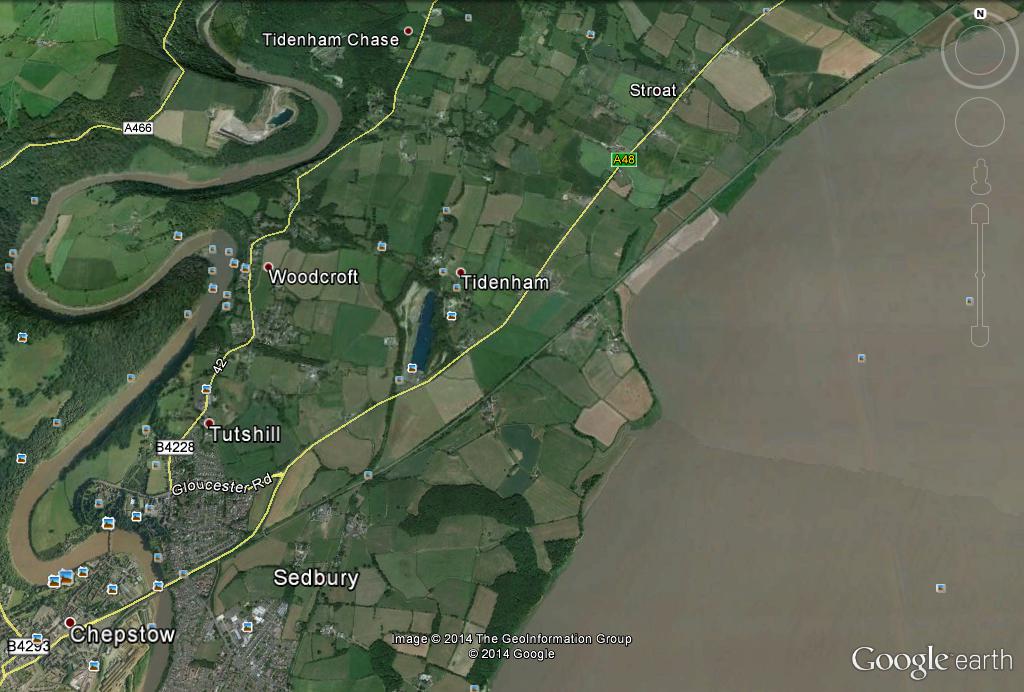
The settlement at Stroat grew up where the main Gloucester-Chepstow road was crossed by the ancient trackway from the Severn; in the earlier 18th century a track, variously described as a highway and a horse-path, still linked Stroat to the river (fn. 69) and the landing-places and fisheries at the two inlets known by the 16th century as Horse Pill and Walden Pill. (fn. 70) The hamlet was linked to Churchend by an alternative route running through the fields to the north of the main road by Garston and Philpots Court; it was known as Hoball Lane in 1630 and was described as the way from Stroat to Tidenham church. (fn. 71) Most of the seven customary tenants holding land at Stroat from Tidenham manor in 1584 (fn. 72) and the 14 families recorded in the tithing c. 1775 (fn. 73) evidently lived in houses on the main road. The settlement there has remained a small one. There are only two houses of any size, the 17th-century Stroat Farm on the north-west of the road and the 18th-century Stroat House (fn. 74) on the opposite side, and there are a number of 18th- or early-19th-century cottages. A cottage opposite Stroat House was the George Inn from at least 1744 and was for many years the meeting-place of the Tidenham manor court. (fn. 75) The inn, which in the later 19th century was known as the ‘George and Dragon’, was closed c. 1900. (fn. 76) At Clap-y-Atts between Stroat and Woolaston a pair of stone cottages with mock timber-framing in the gables was built by Sir Percival Marling in 1905 to house disabled soldiers of his regiment. (fn. 77) The population of Stroat tithing had risen to 176 in 37 houses by 1841, (fn. 78) apparently the result of scattered building both on the main road and in the north part of the tithing after inclosure of the chase. Only one house had apparently existed before the 19th century in the chase area of the tithing, the Chase House, a stone cottage faced in plaster standing by the Coleford road, which had been built by 1769. (fn. 79) It was an inn in the early 19th century, (fn. 80) but in 1920 the forester on the Marling estate lived there while the estate carpenter and mason occupied a pair of stone cottages further north (fn. 81) built by Sir William Marling in 1898. (fn. 82)
In the medieval period most of the houses of Sedbury tithing appear to have been in the north part of the tithing where Sedbury Lane, branching towards Beachley out of the Gloucester-Chepstow road, met a road leading from the Severn at Pighole Pill (fn. 83) and probably continuing across Sedbury to Chepstow Bridge. The latter road was evidently connected with the river passage from Shepherdine on the east bank of the Severn, which was recorded in 1563 (fn. 84) and was still in regular use by people going to market at Chepstow in the mid 19th century when, depending on the state of wind and tide, either Pighole Pill or Slimeroad Pill, south of Sedbury Cliffs, was used as the western terminal. (fn. 85) The road to Pighole Pill was presumable the highway from Sedbury to the Severn recorded in 1666, (fn. 86) and in 1712 it was known as Bird’s Lane. (fn. 87) In 1815 another track existed running south along the bank from Pighole Pill, connecting it with Slimeroad Pill and the road to Beachley. (fn. 88) There was a village cross at the junction of Sedbury Lane and Bird’s Lane in 1499 and at least three houses then stood north-east of the junction where in 1969 were Tump Farm and some rough-cast cottages of the late 18th or early 19th century. By 1499 there was also a house at Anwards on Bird’s Lane, (fn. 89) where the ruins of a stone house remained in 1969. Lowcroft House mentioned in 1583 evidently stood further north near Lowcroft Barn. (fn. 90) A house to the south of the junction, later called Old Sedbury, was recorded from 1638, (fn. 91) and was rebuilt as a pair of stone cottages by George Ormerod of Sedbury Park in 1866. (fn. 92) Sedbury Farm to the west of Sedbury Lane was one of the farm-houses on the Tidenham manor estate in 1769. (fn. 93) The Mead further north was rebuilt c. 1770 when it was the centre of a considerable estate. (fn. 94)
An early settlement further south was at Badams Court where the manor-house of Beachley manor, which once included much of Sedbury tithing, was located in the early 14th century. (fn. 95) The south part of the tithing was formerly known as Barnes, a name which sometimes appears as ‘Barons’ (fn. 96) and was apparently an allusion to the baronial status claimed by John ap Adam, lord of Beachley manor. (fn. 97) A house at Barnes standing near the junction of Sedbury Lane and the road from Tutshill was recorded in 1638, (fn. 98) and Barnes Farm, to the southeast of the junction, from the early 18th century. (fn. 99) Buttington Cottage further south near Offa’s Dyke belonged to the Hitchings family in 1716, (fn. 1) and later served as one of the lodges of Sedbury Park, (fn. 2) the large mansion to the east which was the chief house at Sedbury from the beginning of the 19th century. (fn. 3) A house had been built at Pennsylvania, west of Buttington Tump, by 1748 (fn. 4) and was rebuilt as a gabled stone building by George Ormerod in 1851. (fn. 5) In 1746 there was an inn called the ‘Cock’ at Bunker’s Hill on the road from Tutshill. (fn. 6) Sedbury tithing with 26 families was the most populous of the six tithings of the parish c. 1710, (fn. 7) but there had been a fall in population by the 1770s when 19 families were enumerated; (fn. 8) in 1841, however, the tithing had a population of 173 in 32 houses. (fn. 9)
During the 20th century the western part of Sedbury tithing has been transformed. A prisonerof-war camp was built north-east of the road to Tutshill in the First World War, and at the end of the war a semi-circle of houses in terraces of varying sizes, known as Pennsylvania Village, was built on Offa’s Dyke to house workers at a ship-building yard at Beachley. (fn. 10) Council and private housing development followed and by 1969 the area between Pennsylvania Village and the camp was occupied by a large modern settlement with a public house, school and shops.
The village of Beachley in the southern peninsula of the parish grew up around the Severn passage and most of its inhabitants formerly gained a living by the passage and the several inns which served its users, or by other callings connected with the river. The road leading through the village was recorded as the highway leading to the passage in 1429; (fn. 11) it followed a fairly straight course along the river bank to the passage house until 1893 when it was diverted from the east to the west side of a large house called Beachley Lodge. (fn. 12) Beachley was evidently a fairly compact settlement by 1624 when the road was called Beachley village street, (fn. 13) and in 1675 it was described as a small village with two very good inns. (fn. 14) One of the inns was evidently the passage house, then called the ‘Green Dragon’, and the other either the ‘George’, (fn. 15) or the ‘Ship’ which existed in addition to the other two inns in 1728. (fn. 16) Beachley tithing contained 20 families c. 1710 (fn. 17) but there had been a decline in population by c. 1775 when only 11 families were enumerated. (fn. 18) The village expanded in the late 18th and early 19th century, however, and by 1841 the tithing contained 224 inhabitants in 39 houses, (fn. 19) and a chapel and school had been built. (fn. 20) The most substantial surviving house, Beachley Farm, a rectangular building of two stories and attics with sash windows, dates from the early 19th century. Beachley Lodge was also built at the same period and was known as the New House in 1815; it was then occupied by Richard Jenkins (d. 1834) (fn. 21) who was one of the founders of the Old Passage Ferry Association, (fn. 22) and after c. 1850 it was the home of Robert Castle Jenkins and his successors in the Beachley manor estate. (fn. 23) By 1815 an outlying group of two or three cottages had been built on the road to the north of the village, and in 1824 they included the Salmon Inn. (fn. 24)
The expansion of the village in the early 19th century was evidently due in part to the improvements at the passage in the 1820s, and c. 1830 the success of that venture encouraged the promotion of a scheme, never realized, to develop Beachley as a watering-place with a promenade and dwellinghouses extending round Beachley Point. (fn. 25) During the earlier 19th century customs officers occupied a cottage in the village (fn. 26) (still known as the Custom House in 1969) and manned a look-out post on Beachley Point; (fn. 27) shipping bound up river to Gloucester put in to Beachley Bay to be searched. (fn. 28) In 1841 a tide-surveyor, a mail-inspector, and an engineer (who presumably worked the passage steam-boats) were also living in the village, (fn. 29) while other inhabitants connected with the river and its trade in the 19th century were mariners, pilots, shipwrights, and fishermen. (fn. 30) An annual regatta was held off Beachley from 1839. (fn. 31) A small stone building with pedimented windows facing down the ferry pier, and apparently built at the same time, (fn. 32) was the Beachley Coffee Rooms in the late 19th century. (fn. 33) During the First World War a large national ship-building yard was established to the west of Beachley village and the inhabitants were temporarily evicted from their homes; the shipyard never completed a vessel and the scheme was abandoned soon after the war. (fn. 34) By 1927 the site had been taken over by the Army Apprentices College, (fn. 35) the extensive buildings of which dwarfed the village in 1969. Several of the older houses of the village have been demolished, including four cottages which stood south of the ferry pier, (fn. 36) the old passage house, and Beachley Lodge; Beachley has been further altered in character by a line of bungalows almost linking it with Sedbury and by the dominating structure of the Severn Bridge.
The original settlement in Bishton tithing was apparently the small group of houses lying around the junction of three lanes, Rye Lane (fn. 37) coming from Cross Hill, Cambridge Lane (fn. 38) leading from the Chepstow-Coleford road in the west, and a lane running north from the Gloucester-Chepstow road. In 1769 the houses there included Bishton Farm to the west of the junction, Rye Farm to the east, and another farm-house to the south. (fn. 39) In 1813 all three were stone houses with tiled roofs, as Bishton and Rye Farms remained in 1969, although faced with rough-cast; the third farm-house was in ruins in 1813 (fn. 40) and was later demolished. Another farmhouse standing some way to the west on Cambridge Lane was known as Old Bishton Farm in 1830. (fn. 41) Wirewood’s Green to the south-west was apparently an early settlement: Roger of Wirewood was reeve of Tidenham manor in 1270, (fn. 42) and in 1306 a number of tenants of the manor had that surname. (fn. 43) A house at Wirewood’s Green was recorded in 1565, (fn. 44) and was described as a mansion house in 1677. (fn. 45) The present house, which consists of a central block flanked by gabled wings, may be basically of the 16th century, but apart from massive chimneys on the outer wall of each wing there are now no features remaining which clearly date from before the 18th century. In 1769 the house had a long avenue of trees leading southwards to a gate on the main road (fn. 46) but only part of the avenue survived in 1969 because of the recent construction of an approach road for a new housing estate. The only house near the crossroads at Tutshill before the 19th century was apparently Tutshill Farm (fn. 47) recorded from 1655. (fn. 48) Chapel House Farm, which stood further west in 1769 on the old road down to Chepstow Bridge, (fn. 49) may have been the house belonging to the near-by chapel of St. David in 1530. (fn. 50) A house had been built on the common adjoining the Sedbury road south of Tutshill by 1712, (fn. 51) and there were two or three there by 1815, including Severn Lodge, (fn. 52) a three-storied house with a front of three bays and a central pedimented doorway. There were only a few houses in the north of the tithing scattered along the road to Coleford before the 19th century. They included a house called Penmoil and another called Dunley House, both recorded in 1655 and standing west of the road at Woodcroft, one at Broadrock further north mentioned in 1719, (fn. 53) and one built by 1762 on Spittlemesne Common, (fn. 54) perhaps the house there which was the inn called the ‘Travellers’ Rest’ by 1815. (fn. 55) Powder House Farm standing east of the road between Tutshill and Woodcroft was one of the farm-houses on the Tidenham manor estate in 1769 (fn. 56) and was a stone house with a thatched roof in 1813. (fn. 57) At least one cottage had been built on the common east of the road at Woodcroft by 1712, (fn. 58) and by 1815 there was a small settlement of six or seven cottages there. (fn. 59)
Bishton tithing had 16 families c. 1710 (fn. 60) and 19 c. 1775; (fn. 61) by 1841, however, it was easily the most populous of the tithings with 425 inhabitants in 85 houses and there were also 21 empty houses, presumably just built. (fn. 62) By the middle of the century the tithing’s new population required a chapel of ease and a school, which were built on the road between its two growing centres at Tutshill and Woodcroft. (fn. 63) The expansion of Tutshill had begun by 1828 when building-plots north-east of the cross-roads there were sold, (fn. 64) and by 1843 there were houses extending along the roads to the north and east with the Cross Keys Inn at the corner. (fn. 65) The houses built there included Gloucester House on the east, a small two-storied stuccoed villa with shutters to the ground-floor windows and an ironwork verandah, and Ty-Gwilym on the north, a similar house with architraves to the windows and a more elaborate verandah. There was another period of expansion in the late 19th century and early years of the 20th when the southern side of the Gloucester-Chepstow road east of the cross-roads was developed with detached and semi-detached houses, a row of houses in pairs or terraces was built on the north of the road to Tutshill railway halt, and other houses were built around the minor roadjunction to the north of the cross-roads; many of the houses of that period are in the local stone but brick was also being used for the first time in quantity. By 1856 Tutshill was already a minor centre with two public-houses, a shop, a post office, a solicitor’s office, and a private school, (fn. 66) and in 1894 22 private residents and 6 lodging-houses at Tutshill were listed. (fn. 67) Expansion continued during the 20th century and there was a major increase in the population in the middle years of the century with new housing-estates on the road to Tutshill railway halt, between the cross-roads and Wirewood’s Green, and to the south on the Beachley road. There is a small group of houses by the Wye below Tutshill: it includes Wyecliffe House by Chepstow Bridge, a three-storied late 18th-century house with sash windows and a ground-floor verandah, and, on the promontory to the west, a row of brick houses said to have been built c. 1900 with the product of the near-by brickyard, (fn. 68) and some modern bungalows. During the 19th century there was also steady development at Woodcroft which had become a sizable hamlet by the end of the century with cottages, although still reasonably scattered, covering much of the area of the former common, and some more widely spaced along the road to the north. Most of the single and paired cottages there are faced in rough-cast and most are presumably built of stone as are two larger terraces. In the mid 20th century numbers of detached houses were built along the road running northwards from Woodcroft and up onto the former chase, their owners attracted by the views over the Severn to the east and the dramatic Wye scenery on the west.
A feature of the western part of the parish is the number of large residential houses set in spacious grounds, most of them built in the earlier 19th century. The house formerly called Tutshill House (fn. 69) but in 1969 St. John’s-on-the-Hill, standing southwest of the cross-roads at Tutshill, was in an unfinished state in 1806 when a builder contracted with Sir George Bolton for its completion. (fn. 70) It is a two-story stone house having a front with flanking bay windows and an ironwork balcony at first-floor level; a contemporary stable-block with an arcaded front stands near-by. In 1969 the house was a boys’ preparatory school. Castleford, further west commanding a view across to Chepstow castle, was built before 1879; (fn. 71) it comprises a Gothic house built of red and blue brick, to which a stone garden front in Jacobean style was added by the owner, W. R. Lysaght, in 1912. (fn. 72) Other additions were made c. 1960 when the house became a sales and service depot for a lawn-mower company. (fn. 73) Tutshill Lodge on the south of Tutshill had been built by 1843; (fn. 74) it is a square two-storied stuccoed house with a three-bay front with a central doorway and flanking windows set in arched recesses. At Penmoil, west of Woodcroft, there was a house called Penmoil Cottage in 1815, (fn. 75) perhaps on the same site as that recorded in 1655, (fn. 76) and in 1890 Penmoil was a fairly large two-story house with bay windows. (fn. 77) It was rebuilt early in the 20th century (fn. 78) as an ornate house of stone with mock timber-framed gables and a Gothic porch. There was a house at Eastcliff south of Penmoil by 1815, (fn. 79) and it was apparently rebuilt or remodelled c. 1830; (fn. 80) Eastcliff was again rebuilt in the 1920s (fn. 81) as a two-story stone building in Queen Anne style. Dennel Hill, a stone house of two stories perched on the cliffs above the Wye, had been built by 1840, (fn. 82) and East Vaga, further north, by 1856. (fn. 83)
The parish of Lancaut, which apparently had a church from Saxon times, (fn. 84) was evidently once a settlement of some size. In 1306 Tidenham manor had 10 tenants at Lancaut. (fn. 85) In 1551 the parish had c. 19 communicants, (fn. 86) and in 1563 there were 5 households there. (fn. 87) There were four families living at Lancaut c. 1710 (fn. 88) and by 1750 it had only two inhabited houses. (fn. 89) One of the houses belonged to Mr. Jones and was evidently the farm-house standing on the north side of the road there which belonged to the Tidenham House estate in 1815; (fn. 90) the present house there is a 19th-century stone cottage. The other house in 1750 belonged to Mr. Stevens, of a family who were recorded at Lancaut from 1559, (fn. 91) and was apparently Lancaut Farm standing south of the road. It comprises a twostory range of rough-cast stone with diagonally-set stone chimneys and sash windows to the garden front; it apparently dates mainly from the 18th century although there is some evidence of an earlier timber-framed structure at the south end of the house. The only other house in the peninsula in 1815 was a building, described as a cottage and fish-house, on the river bank south of the church; (fn. 92) it was apparently unoccupied in 1839 (fn. 93) and only a few stone ruins remained in 1969.
The Gloucester-Chepstow road was the chief highway through the parish and the one most often recorded as needing repair; in 1668 the inhabitants of Bishton were required to repair a stone bridge on the road, and a causeway on another part was to be repaired by the adjoining tithings in 1697. (fn. 94) The road was turnpiked in 1757-8 together with the road leading out of it at Tutshill to the Beachley passage. (fn. 95) Turnpike houses were built at the Tutshill crossroads and north of Beachley village. In 1769 the main road to Chepstow made a sharp turn to the south just beyond Tutshill and led directly down the hill to Chepstow Bridge, (fn. 96) but by 1815 an easier route curving round to the west had been substituted. (fn. 97) The old road, a steep descent between high stone walls, was later closed to traffic.
Chepstow Bridge, carrying the main road across the Wye, was recorded from 1228. (fn. 98) About 1540 the bridge, a timber one, was described as ruinous; (fn. 99) it may have been rebuilt in the 1540s. (fn. 1) In 1576, however, it was described as a great wooden bridge in great decay when an Act was passed making Gloucestershire and Monmouthshire responsible for the repair of their respective halves of the bridge. (fn. 2) Neglect continued, however, and in 1606 the bridge was said to have fallen down and been carried away; the earlier Act was then replaced by another which included a provision for penalties on the magistrates for failure to levy rates for the repairs. (fn. 3) By 1673 maintenance of the Gloucestershire side of the bridge was in the hands of salaried surveyors who carried out considerable repairs between then and 1681; (fn. 4) in 1676 the surveyors were empowered to build a house in which timber and other materials could be stored, (fn. 5) and in 1703 they had the use of a warehouse and a boat. During the 18th century individuals contracted with the county to maintain the bridge for terms of years. (fn. 6) At the beginning of the 18th century the bridge comprised a wooden decking carried by a central stone pier and five piers on either side each formed by a number of timber piles; the height of the piers was considerable, to allow for the high rise of the tides. (fn. 7) The Monmouthshire half of the bridge was rebuilt as four stone arches in 1785, but the Gloucestershire half remained timber until 1815 when a complete rebuilding of the bridge was begun to the designs of John Rennie. The new bridge, opened the next year, comprises five cast-iron arches carried on stone piers and has a central span of 112 ft. (fn. 8)
The South Wales Railway through the parish was opened as far as a temporary station near Churchend in 1851 pending the completion of the bridge to carry the line over the Wye. The bridge was opened to two-way traffic in 1853. Designed by I. K. Brunel, it is a tubular suspension bridge with a span of 300 ft. from the cliff-top on the Tutshill side to the first pier on the much lower Chepstow bank, and three further land spans each of 100 ft. (fn. 9) In 1876 the Wye Valley Railway was completed, branching out of the South Wales Railway at Sedbury and passing through a tunnel 1,188 yards long from Netherhope to the banks of the Wye below Dennel Hill. (fn. 10) There was a station near Churchend and halts at Tutshill and Netherhope, which were closed in 1959. The Wye Valley line then ceased to carry passenger traffic, (fn. 11) and by 1969 the rails had been taken up along the river bank and the line was already much overgrown, but the southern part of the line was still used by the quarries at the north end of the tunnel and at Coombesbury Wood to take stone to the main line. A temporary line connecting the Beachley shipyard with the main line existed for a period after the First World War. (fn. 12)
Forty-eight tenants of Tidenham manor were recorded in 1066 and by 1086 the number had increased by 12. (fn. 13) Over 160 tenants were recorded in Tidenham and Lancaut in 1306. (fn. 14) There were said to be c. 260 communicants in Tidenham parish in 1551, (fn. 15) and 40 households in 1563. (fn. 16) In 1650 the population of Tidenham was estimated at 100 families. (fn. 17) About 1710 there were said to be c. 600 inhabitants in Tidenham and Lancaut and about estimate or the second an underestimate as both writers give a total of c. 110 families in the various tithings; the figures given for the families in the tithings, if accurate, indicate that during the earlier 18th century the growth of population in new settlements in Wibdon, Churchend, and Bishton was offset by the decline in population in the older settlements at Sedbury and Beachley. (fn. 18) There was apparently some increase in the later part of the century, however, and in 1801 Tidenham parish had a population of 696 in 138 houses. There was then a steady if gradual rise in population to 1,736 by 1891; there had been little change by 1911, but by 1921, partly because of the Beachley shipyard, the population had risen to 2,248. There was then a steady rise to 3,147 in 1931 and 4,195 in 1961. (fn. 19)
From the time of William FitzOsbern in the 11th century Tidenham had close tenurial connexions with the neighbouring Monmouthshire town of Chepstow, which also dominated the parish economically as a market and port; from the mid 19th century the western part of the parish has been increasingly developed as a residential area for Chepstow. The manor of Tidenham continued to be administered with the Duke of Beaufort’s Monmouthshire estates until the 19th century, and the dukes, although usually acting through agents, were influential in the parish. The second most important estate, comprising Beachley and Waldings manors, was also connected tenurially with Monmouthshire, being held for many years by the Lewis family of St. Pierre. (fn. 20) Tidenham also had close connexions with Bristol to which it was linked by way of the Beachley passage; the James family (fn. 21) were only the most notable of a number of inhabitants of Bristol holding land in the parish during the 17th and 18th centuries. (fn. 22) In the 19th century there were several families who took the lead in providing education, places of worship, and social welfare, including landowners such as the Ormerods of Sedbury Park (fn. 23) and the Jenkinses of Beachley, (fn. 24) and the owners of Eastcliff, (fn. 25) Penmoil, (fn. 26) and the other large houses in the west of the parish. The Morgan family of Tidenham House was particularly active: in the 1870s Evangelical services were organized and coffee supplied at a building in Woodcroft by Sophia Morgan, partly in an attempt to combat drunkenness among the Irish labourers building the Wye Valley railway; (fn. 27) the Memorial Temperance Hall, a two-story stone building erected at Woodcroft by Christiana Morgan in 1887 in memory of her husband T. H. Morgan was used for religious services, coffee rooms, and reading rooms, (fn. 28) and similar activities took place at the Stroat Mission built by her daughter Emily Morgan in 1888. (fn. 29) A number of male and female friendly societies were started in the parish in the 1830s and 1840s, (fn. 30) and there was a social club and institute at Tutshill by 1889. (fn. 31)
The Beachley passage, described in 1644 as the key to Wales, (fn. 32) was of considerable strategic importance in the Civil War as a link between the king’s forces in Wales and the south-west. In September 1644 Prince Rupert sent a force of 500 horse and foot to secure the passage, who fortified a position across the Beachley peninsula. A few days later the force was attacked and defeated by Governor Massey, who took advantage of low water when the guns of the royalist ships in the rivers could not command the peninsula. (fn. 33) In October the peninsula was again occupied by royalists in similar strength under Sir John Winter who in their turn were attacked and defeated by Massey who took 220 prisoners and killed 30, although Winter himself escaped; (fn. 34) a parliamentary garrison remained in Tidenham a month later. (fn. 35) Winter was again active in the area in late February or early March of 1645 when he broke out from his house at Lydney and led a force to Lancaut in an attempt to fortify a crossing-point over the Wye, but he was again defeated and forced to make his escape. (fn. 36) Winter’s successful evasion of the parliamentary forces after the battle at Beachley (or conceivably after the battle at Lancaut) gave rise to the tradition that he had leapt his horse down the precipitous Lancaut Cliff, part of which became known as Winter’s Leap. (fn. 37)
Attempts have been made to identify Buttington Tump in the Beachley peninsula with the place on the Severn where Alfred’s forces besieged the Danes in 893, (fn. 38) but that engagement almost certainly took place at Buttington in Montgomeryshire. (fn. 39)
At least one native of Lancaut parish achieved a position of note; he was Henry of Lancaut who, apparently in the 13th century, was abbot of De Voto, Tintern Abbey’s daughter house in Ireland. (fn. 40) Arthur Bedford (1668-1745), a writer on miscellaneous subjects, was born at Tidenham, (fn. 41) and was perhaps the son of Richard Bedford, vicar there from c. 1660 until his death in 1708. (fn. 42) George Ormerod, the antiquary, author of a history of Cheshire and a number of essays on the history of Tidenham and the locality, was resident at Sedbury Park from the 1820s until his death in 1873. His daughter Eleanor (1828-1901) became a distinguished entomologist. (fn. 43)
Footnotes
1 Grundy, Saxon Charters, 241; A. J. Robertson, AngloSaxon Charters (1956), 204-7.
2 The Lancaut tenants were listed separately in an extent of the manor in 1306 and did not do the full scale of labour-services owed by the Tidenham tenants: Inq. p.m. Glos. 1302-58, 63-73.
3 See p. 77.
4 O.S. Area Bk. Lancaut (1881); Census, 1931 (pt. ii).
5 Grundy, Saxon Charters, 241; Robertson, A.-S. Charters, 204-7.
6 C. Fox, Offa’s Dyke (1955), 216-17.
7 Grundy, Saxon Charters, 241; cf. the bounds given in 1584: N.L.W., Badminton MS. 2494.
8 O.S. Map 6″, Glos. XLVI. SE. (1891 edn.).
9 See pp. 104-5.
10 Glos. R.O., P 333A/SD 1/1.
11 O.S. Area Bk. Woolaston (1881).
12 Grundy, Saxon Charters, 239.
13 Dom. Bk. (Rec. Com.), i. 164; see below, p. 107.
14 Census, 1891.
15 G.D.R. Tidenham tithe award.
16 See p. 74.
17 E 32/30 m. 21 and d.
18 O.S. Area Bk. Tidenham (1881), addenda.
19 Census, 1931 (pt. ii).
20 O.S. Area Bk. Tidenham (1881).
21 Quart. Jnl. of Geol. Soc. lix. 390-402.
22 Geol. Surv. Map (solid edn.), sheet 35.
23 S.C. 6/859/18, 22.
24 Cf. O.S. Map 1/25,000, ST 59 (1960 edn.).
25 N.L.W., Badminton MS. 2494, entries for 1668, 1670; ibid. 1729, entry for 1715.
26 Geol. Surv. Map (solid edn.), sheet 35.
27 S.C. 6/859/22.
28 N.L.W., Badminton MS. 2494.
29 Ibid. 14648.
30 See p. 72.
31 Close R. 1227-31, 98-99.
32 E 146/1/25.
33 Rot. Hund. (Rec. Com.), i. 176, 181.
34 Trans. B.G.A.S. lxvi. 175.
35 Cal. Pat. 1266-72, 275.
36 E 32/30 m. 12.
37 Trans. B.G.A.S. lxvi. 176-80.
38 E 32/30 m. 21 and d.
39 See p. 69.
40 Dom. Bk. (Rec. Com.), i. 164.
41 N.L.W., Badminton MS. 2494; Badminton Mun. F Drawer 2, map, 1769.
42 N.L.W., Badminton MS. 12896; cf. ibid. 13047.
43 Glos. R.O., P 333A/SD 1/1.
44 Badminton Mun. F Drawer 2, map.
45 Glos. R.O., D 262/T 19.
46 Glos. R.O., D 262/T 15, T 29.
47 Ibid. P 333A/SD 1/1; D 1430B/11.
48 Glos. Colln. RX 306. 1.
49 Trans. B.G.A.S. lxxiii. 238.
50 N.L.W., Badminton MS. 2494; S.C. 6/859/24.
51 S.C. 6/859/22, 25.
52 Badminton Mun. F Drawer 2, map, 1769.
53 S.C. 6/859/19-21, 27.
54 Ibid. 19.
55 Inq. p.m. Glos. 1302-58, 63.
56 N.L.W., Badminton MS. 2494.
57 Badminton Mun. F Drawer 2, map, 1769; the name is thought to derive from a legend that the devil once preached to the monks of Tintern from there: ex inf. Miss G. Joyce, formerly of Stroat House, Tidenham.
58 Fox, Offa’s Dyke, 191-8, which traces in detail the course of the dyke through the parish. Part of Buttington Tump was removed during road-widening in 1960: Trans. B.G.A.S. lxxxii. 202-4.
59 C. Hart, Archaeology in Dean (1967), 14-15.
60 Ibid. 14; cf. Glos. R.O., P 333A/SD 1/1.
61 G. Ormerod, Strigulensia (1861), 4 n., 41; Hart, Arch. in Dean, 20.
62 Trans. B.G.A.S. lxxiv. 15-35.
63 Ibid. 15-17; Hart, Arch. in Dean, 22.
64 S.C. 6/859/17.
65 See Hart, Arch. in Dean, plate XI; they were presumably the Hoar Stones on Garston farm mentioned in Bigland, Glos. iii, no. 271.
66 See above.
67 N.L.W., Badminton MS. 2494.
68 Margary, Rom. Roads, ii. 55-56; O.S. Map 1/2,500, Glos. LIV. 10 (1886 edn.).
69 Ormerod, Strigulensia, 8; Hart, Arch. in Dean, plate XVII.
70 Ormerod, Strigulensia, 39; Trans. B.G.A.S. lxxiii. 237-; lx, plate IV at pp. 304-5.
71 Ex inf. Mr. P. E. Goatman, of Tidenham.
72 Ormerod, Strigulensia, 43-48.
73 Ibid. 41.
74 W.I. hist. of Tidenham (TS. in Glos. Colln. 1958), 1.
75 Cal. Chart. R. 1300-26, 88.
76 Cal. Papal Regs. vi. 24.
77 See below.
78 Rudder, Glos. 765.
79 Defoe, Tour Thro’ G.B. (1753), ii. 305.
80 Glouc. Jnl. 7 Sept. 1839.
81 Ibid. 5 May 1855.
82 N.L.W., Badminton MS. 2494.
83 Ibid. 2607.
84 Glos. R.O., D 1430B/9; the rent from Aust was paid by James Jenkins and that from Beachley by Robert Castle Jenkins who had presumably inherited Richard Jenkins’s interest with Beachley Lodge: see below.
85 Glos. R.O., D 726/3, f. 82 and v.
86 Ibid. D 262/T 3.
87 Ibid. D 674A/T 240.
88 Ibid. T 226-7.
89 Glos. Colln. deeds 306.3.
90 Glos. R.O., EL 201, p. 173.
91 Ibid. D 674A/T 227.
92 Ibid. T 228.
93 Ibid. D 726/3, f. 83.
94 Glos. R.O., D 262/T 2; Rudder, Glos. 765.
95 Rudder, Glos. 765; cf. below, p. 65.
96 Glos. R.O., D 674A/T 227.
97 Ibid. EL 201, p. 173.
98 Ibid. D 674A/T 228.
99 Ibid. P 333A/SD 1/1.
1 I. Waters, Chepstow Miscellany (1958), plate facing p. 23; the embankment and slipway still existed in a ruined state in 1969.
2 Glos. R.O., EL 201, p. 173.
3 Ibid. D 674A/T 227.
4 Glouc. Jnl. 11 May 1767.
5 The account of the passage after 1825 is based on Farr, Chepstow Ships, 17-18.
6 See p. 65; Glos. R.O., P 333A/SD 1/1.
7 Cf. Glos. R.O., D 1833/E 6; Q/RUm 109.
8 Ibid. D 1430B/26.
9 Vestry min. bk. 1819-68, penes the vicar.
10 Cf. Glouc. Jnl. 7 Sept. 1839; Eleanor Ormerod . . . Autobiography and Correspondence, ed. R. Wallace (1904), 43-45.
11 L. T. C. Rolt, The Severn Bridge (souvenir booklet, 1966); cf. Glos. R.O., D 1430B/32; Glos. C. C. Mins. vii. 23; xxxv. 144.
12 Rolt, Severn Bridge.
13 Robertson, A.-S. Charters, 204-7.
14 See p. 68.
15 O.S. Area Bk. Lancaut (1881).
16 P.N. Glos. (E.P.N.S.) iii. 265.
17 N.L.W., Badminton MS. 2494.
18 Inq. p.m. Glos. 1302-58, 72.
19 Glos. Colln. deeds 306. 5.
20 Glos. R.O., D 262/T 6; it was presumably the ‘Soncheburi’ mentioned in 1306: Inq. p.m. Glos. 1302-58, 72.
21 N.L.W., Badminton MS. 2494.
22 e.g. Atkyns, Glos. 773; Bryant, Map of Glos. (1824).
23 S.C. 6/859/20.
24 See p. 73.
25 See p. 63.
26 Glos. R.O., D 726/3, ff. 64, 73.
27 See p. 63; cf. P.N. Glos. (E.P.N.S.) iv. 119.
28 N.L.W., Badminton MS. 2536/2.
29 Inits. and date on bldg.
30 N.L.W., Badminton MS. 2543; cf. Glos. R.O,. P 333A/SD 1/1.
31 Kelly’s Dir. Glos. (1856 and later edns.).
32 Badminton Mun. F Drawer 2, map, 1769.
33 Ibid. 104. 1. 11.
34 See p. 65.
35 N.L.W., Badminton MS. 2494.
36 Badminton Mun. 104. 1. 11.
37 Glos. R.O., P 333A/SD 1/1.
38 Ibid. D 262/T 9.
39 Ibid. P 333A/SD 1/1.
40 N.L.W., Badminton MS. 1728.
41 Glos. R.O., EL 201, p. 119; N.L.W., Badminton MS. 2494, entry for 1670; cf. Glos. R.O., P 333A/SD 1/1.
42 Glos. R.O., P 333A/SD 1/1.
43 Local information.
44 Glos. R.O., P 333A/SD 1/1; local information.
45 Atkyns, Glos. 775.
46 Rudder, Glos. 765.
47 Census.
48 Glos. R.O., D 726/3, ff. 62-63, 66-68, 70.
49 See p. 64.
50 Glos. Colln. deeds 306. 8.
51 Inits. and date on bldg.; cf. p. 66.
52 Glouc. Jnl. 15 Oct. 1804.
53 Atkyns, Glos. 776.
54 Rudder, Glos. 765.
55 N.L.W., Badminton MS. 2536/2.
56 See above.
57 N.L.W., Badminton MS. 2494.
58 Glos. Colln. deeds 306. 15.
59 Glos. R.O., P 333A/SD 1/1.
60 See p. 67; Glos. Colln. RX 306. 1.
61 Cf. G.D.R. Tidenham tithe award; O.S. Map 6″, Glos. XLVI. SE. (1891 edn.).
62 Glos. R.O., P 333A/SD 1/1.
63 See p. 105.
64 N.L.W., Badminton MS. 2560.
65 Ex inf. Miss Joyce; cf. Glos. Colln. RV 306. 1.
66 Census.
67 See p. 78.
68 See p. 75.
69 N.L.W., Badminton MSS. 2494 (entry for 1707), 2535.
70 Ibid. 2494; cf. G.D.R. Tidenham tithe award.
71 Glos. R.O., EL 201, p. 118.
72 N.L.W., Badminton MS. 2494.
73 Rudder, Glos. 765.
74 See p. 66.
75 N.L.W., Badminton MSS. 2536/1, 2563; Glos. R.O., D 1430B/8; cf. G.D.R. Tidenham tithe award.
76 Ex inf. Miss Joyce.
77 Glos. R.O., D 262/T 25A; date and inits. on bldg.
78 Census.
79 Badminton Mun. F Drawer 2, map, 1769.
80 Ibid. 104. 1. 11.
81 Glos. Colln. RV 306. 1.
82 Date and inits. on bldg.
83 Glos. R.O., D 262/T 6.
84 Hockaday Abs. ccclxxv.
85 Ormerod, Strigulensia, 6.
86 N.L.W., Badminton MS. 2494.
87 Ibid. 1728.
88 Glos. R.O., P 333A/SD 1/1.
89 Ibid. D 262/T 6.
90 Glos. Colln. deeds 306. 6.
91 Glos. R.O., D 262/T 7; cf. P 333A/SD 1/1.
92 Date and inits. on bldg.
93 Badminton Mun. F Drawer 2, map, 1769.
94 See p. 67.
95 See p. 65.
96 S.C. 6/Hen. VIII/2495; Glos. R.O., EL 201, p. 116.
97 Cf. p. 65.
98 Glos. R.O., D 262/T 7.
99 Ibid. T 15; cf. T 29, map of 1797.
1 Ibid. T 2; cf. Badminton Mun. F Drawer 2, map, 1769.
2 Glos. Colln. RV 306. 1.
3 See pp. 63-64.
4 Glos. R.O., D 262/T 8.
5 Date and inits. on bldg.
6 N.L.W., Badminton MS. 2542; cf. Badminton Mun. F Drawer 2, map, 1769.
7 Atkyns, Glos. 775.
8 Rudder, Glos. 765.
9 Census.
10 Local information.
11 Glos. R.O., D 674A/T 240/9.
12 Vestry min. bk. 1860-1945 penes the vicar; cf. O.S. Map 1/2,500, Glos. LXII. 3. (1881 edn.).
13 Glos. R.O., EL 201, p. 172.
14 Ogilby, Britannia (1675), p. 111.
15 See above.
16 Glos. R.O., EL 201, p. 173.
17 Atkyns, Glos. 775.
18 Rudder, Glos. 765.
19 Census.
20 See pp. 75, 79.
21 Glos. R.O., P 333A/SD 1/1; inscr. in Beachley chapel.
22 See above.
23 Kelly’s Dir. Glos. (1856 and later edns.); cf. below, p. 65.
24 Glos. R.O., P 333A/SD 1/1; Bryant, Map of Glos. (1824).
25 Glos. R.O., D 1430B/26.
26 G.D.R. Tidenham tithe award.
27 Bryant, Map of Glos. (1824).
28 Eleanor Ormerod, 35.
29 H.O. 107/369.
30 See pp. 71-72.
31 Waters, Chepstow Miscellany, 50.
32 Glos. R.O., Q/RUm 109.
33 Kelly’s Dir. Glos. (1879), 564; Waters Chepstow Miscellany, plate facing p. 50. The building then only had a single story; another has been added since.
34 W.I. hist. of Tidenham, 2; Farr, Chepstow Ships, 186; Kelly’s Dir. Glos. (1919), 36.
35 Kelly’s Dir. Glos. (1927), 39.
36 Cf. G.D.R. Tidenham tithe award.
37 Glos. R.O., P 333A/SD 1/1.
38 Ibid. D 262/T 9.
39 Badminton Mun. F Drawer 2, map, 1769.
40 Ibid. 104. 1. 11.
41 O.S. Map 1″, sheet 35 (1830 edn.).
42 S.C. 6/859/17.
43 Inq. p.m. Glos. 1302-58, 65, 67.
44 Glos. R.O., D 674A/T 226.
45 Glos. Colln. deeds 306. 1.
46 Badminton Mun. F Drawer 2, map, 1769.
47 Cf. Glos. R.O., P 333A/SD 1/1.
48 See p. 66.
49 Badminton Mun. F Drawer 2, map, 1769.
50 S.C. 6/Hen. VIII/2495.
51 N.L.W., Badminton MS 1728.
52 Glos. R.O., P 333A/SD 1/1.
53 Ibid. D 262/T 9, T 11; cf. P 333A/SD 1/1.
54 N.L.W., Badminton MS. 1728.
55 Glos. R.O., P 333A/SD 1/1.
56 Badminton Mun. F Drawer 2, map, 1769.
57 Ibid. 104.1.11.
58 N.L.W., Badminton MS. 1728.
59 Glos. R.O., P 333A/SD 1/1.
60 Atkyns, Glos. 775.
61 Rudder, Glos. 765.
62 Census.
63 See pp. 75, 78.
64 Glos. R.O., D 1430B/30.
65 G.D.R. Tidenham tithe award.
66 Kelly’s Dir. Glos. (1856), 376.
67 Ibid. (1894), 327-8.
68 Local information.
69 O.S. Map 1/2,500, Glos. LIV. 10 (1886 edn.).
70 Glos. R.O., D 1430B/19.
71 Kelly’s Dir. Glos. (1879), 770.
72 Ex inf. Mr. D. R. Lysaght, of Dennel Hill, Tidenham.
73 Ex inf. Mr. Pike, depot manager.
74 G.D.R. Tidenham tithe award.
75 Glos. R.O., P 333A/SD 1/1.
76 See above.
77 Photo. penes Lady Waring, of Penmoil.
78 Ex inf. Lady Waring.
79 Glos. R.O., P 333A/SD 1/1.
80 Vestry min. bk. 1819-68.
81 Ex inf. Mr. G. C. Francis, of Eastcliff.
82 Glos. R.O., D 262/T 14.
83 Kelly’s Dir. Glos. (1856), 376.
84 See p. 77.
85 Inq. p.m. Glos. 1302-58, 71-72.
86 E.H.R. xix. 120-1.
87 Bodl. MS. Rawl. C.790, f. 28.
88 Atkyns, Glos. 776.
89 G.D.R. vol. 381A, f. 9.
90 See pp. 65-66.
91 Glos. R.O., D 726/3, f. 272; cf. N.L.W., Badminton MS. 2494, 1584 ct. of survey.
92 Glos. R.O., P 333A/SD 1/1.
93 G.D.R. Lancaut tithe award.
94 N.L.W., Badminton MS. 2494.
95 Mon. & Glouc. Roads Act, 31 Geo. II, c. 44.
96 Badminton Mun. F Drawer 2, map, 1769.
97 Glos. R.O., P 333A/SD 1/1.
98 Close R. 1227-31, 98-99.
99 Leland, Itin. ed. Toulmin Smith, ii. 69; Itin. in Wales, 43.
1 I. Waters, Chepstow Parish Records (1955), 116.
2 Chepstow Bridge Act, 18 Eliz. c. 18; Chepstow Bridge had not been covered by the Act of 1530 making this the general rule where a bridge lay in two counties, because Chepstow and Tidenham were not united to counties until 1536.
3 Chepstow Bridge Act, 3 Jas. I, c.23.
4 Glos. R.O., Q/SO 1, ff. 39v.-40, 59, 99v.-100, 156, 242.
5 Ibid. ff. 105, 121.
6 Waters, Chepstow Par. Recs. 117-18.
7 Atkyns, Glos. plate at pp. 774-5; cf. Rudge, Hist. of Glos. ii. 74-75.
8 Waters, Chepstow Par. Recs. 120-3.
9 MacDermot, Hist. G.W.R. i. 298-9.
10 Ibid. ii. 178.
11 Ex inf. Brit. Rlys. Bd. Hist. Recs. Dept.
12 O.S. Map 1/25,000, ST 59 (1949 edn.).
13 Dom. Bk. (Rec. Com.), i. 164.
14 Inq. p.m. Glos. 1302-58, 63-72.
15 E.H.R. xix. 121.
16 Bodl. MS. Rawl. C.790, f. 28.
17 Trans. B.G.A.S. lxxxiii. 97.
18 Atkyns, Glos. 775-6; Rudder, Glos. 765-6; the first source gives a total of 100 families excluding Stroat, and the second 112 families including 14 in Stroat.
19 Census.
20 See pp. 64-65.
21 See p. 65.
22 e.g. Glos. R.O., D 262/T 2, T 7-8; D 674A/T 227; Glos. Colln. deeds 306.1.
23 See Eleanor Ormerod, 25, 29-30.
24 See pp. 75, 78-79.
25 See p. 75.
26 See p. 78.
27 W.I. hist. of Tidenham, 17.
28 Inscr. on bldg.; Kelly’s Dir. Glos. (1923), 346.
29 Kelly’s Dir. Glos. (1894), 327; ex inf. Miss Joyce.
30 Glos. R.O., Q/RZ 1, 1836-44.
31 Kelly’s Dir. Glos. (1889), 924.
32 Cal. S.P. Dom. 1644, 528.
33 Bibliotheca Glos. ii. 116-17; cf. Cal. S.P. Dom. 1644, 513, 524, 528.
34 Bibliotheca Glos. ii. 122-4; cf. Cal. S.P. Dom. 1644-5, 42, 52.
35 Cal. S.P. Dom. 1644-5, 112.
36 Bibliotheca Glos. ii. 136-7.
37 Rudge, Hist. of Glos. ii. 78; cf. O.S. Map 1″, sheet 25 (1830 edn.).
38 e.g. Ormerod, Strigulensia, 60-61.
39 See F. M. Stenton, Anglo-Saxon Eng. (1947), 264 and n. Besides the fact mentioned by Stenton that the Danes marched along the Thames and then up the Severn to reach Buttington, other particulars of the account of that battle – the statement that the besieging Saxons were encamped on both sides of the river and that the Danes finally broke out through the forces on the east bank – precludes the possibility that it took place by the broad estuary of the Severn at Tidenham: A.-S. Chron. (Everyman edn. 1954), 87.
40 Trans. B.G.A.S. lviii. 211; cf. Tintern Abbey (Min. of Works guide, 1956), 13.
41 D.N.B.
42 Hockaday Abs. lxviii, 1661 visit. f. 4; Glos. R.O., D 726/3, f. 270.
43 For particulars of both, see Eleanor Ormerod. Some of George Ormerod’s essays were published as Strigulensia, and there are manuscript notes and collections of material relating to the locality, made by him, in Glos. R.O., D 726/1-3.
TIDENHAM INCLUDING
LANCAUT & STROAT etc.
Manors and other estates:
Tidenham including Lancaut
Manors and other estates
‘Tidenham including Lancaut: Manors and other estates’, A History of the County of Gloucester: Volume 10: Westbury and Whitstone Hundreds (1972), pp. 62-68. URL: http://www.british-history.ac.uk/report.aspx?compid=15758 Date accessed: 22 October 2014.
Highlight
(Min 3 characters)
Contents
MANORS AND OTHER ESTATES.
Footnotes
MANORS AND OTHER ESTATES.
The large manor of TIDENHAM containing 30 hides was granted by King Edwy in 956 to Wulfgar, Abbot of Bath. After 1052 Bath Abbey leased the manor for life to Archbishop Stigand for 10 marks of gold and 20 pounds of silver and an annual rent of one mark of gold, 6 porpoises and 30,000 herrings. (fn. 44) It passed, apparently on Stigand’s deposition in 1070, to William FitzOsbern, Earl of Hereford (d. 1071), and was forfeited to the Crown on the rebellion of William’s son Roger in 1075. (fn. 45) While William FitzOsbern held the manor he alienated some parts of it: he granted a yardland with one villanus to his brother Osbern, Bishop of Exeter, two and a half fisheries and one villanus to Walter de Lacy, two fisheries and one villanus to Ralph de Limesi, and ½ hide with the church of Tidenham to Lire Abbey. (fn. 46) In 1086 Walter de Lacy’s estate was held by Roger de Lacy and was then described as ½ hide with one villanus and four and a half fisheries, (fn. 47) and Ralph de Limesi’s, described as 1½ yardland with one villanus and two fisheries, had passed to William of Eu. (fn. 48) It is possible that the estates of Roger and William adjoined the estates which both men also held at that time in Madgett (fn. 49) and they may have become amalgamated with the Madgett estates and passed into Woolaston parish. Alternatively, however, the two estates and that granted to Osbern may have been represented by some of the small freehold estates held from Tidenham manor by the Prior of Farleigh and others in 1289. (fn. 50)
The manor of Tidenham passed with the honor of Striguil, based on Chepstow castle, to the de Clares, and the manor was held by the lords of Chepstow until the 19th century. Walter de Clare was succeeded c. 1138 by his nephew Gilbert de Clare who was created Earl of Pembroke in that year and died c. 1148, and the manor passed to Gilbert’s son Richard (d. 1176). Richard’s son Gilbert died a minor c. 1185 when his heir was his sister Isabel who married in 1189 William Marshal, Earl of Pembroke (d. 1219). The manor was then held successively by five sons of William Marshal, William (d. 1231), Richard (d. 1234), Gilbert (d. 1241), Walter (d. Nov. 1245) and Anselm (d. Dec. 1245). (fn. 51) On Anselm’s death his estates were partitioned, Tidenham passing to his sister Maud (d. 1248) and then to her son Roger Bigod, Earl of Norfolk (d. 1270). (fn. 52) Roger was succeeded by his nephew Roger who died in 1306 when in accordance with a previous agreement his lands passed to the Crown. (fn. 53)
In 1310 Edward II assigned Roger Bigod’s estates to his brothers Thomas de Brotherton and Edmund, and in 1312 created Thomas Earl of Norfolk. In 1323 Thomas granted Tidenham for life to the younger Hugh Despenser (fn. 54) and it reverted to him on Despenser’s execution in 1326. After Thomas’s death in 1338 the manor was held by his widow Mary (d. c. 1361) (fn. 55) and it passed to their daughter Margaret, Countess of Norfolk, who married secondly Walter de Mauny, Lord Mauny (d. 1372). (fn. 56) In 1372 Margaret leased the manor for 40 years to her daughter Anne and Anne’s husband John de Hastinges, Earl of Pembroke (d. 1375), (fn. 57) but Anne surrendered it to her mother in 1376. (fn. 58) Margaret died in 1399 and was succeeded by her grandson Thomas Mowbray, Earl of Norfolk, who died later the same year. Thomas was succeeded by his son Thomas then a minor, who was executed for treason in 1405; (fn. 59) in the same year the Crown granted Tidenham manor for life to John Harpeden, (fn. 60) but by 1414 it had apparently been regained by Thomas’s brother and heir John (fn. 61) who held it at his death in 1432. (fn. 62) The manor was assigned in dower to John’s widow Catherine, (fn. 63) whose third husband John Beaumont, Viscount Beaumont, was lord of Tidenham in 1453. (fn. 64) By 1468 the manor had passed to Catherine’s grandson John Mowbray, Duke of Norfolk, who granted it in that year to William Herbert, Earl of Pembroke, who died in 1469. William was succeeded by his son William (fn. 65) (d. 1491), and the younger William by his daughter Elizabeth who married in 1492 Charles Somerset, later Earl of Worcester. (fn. 66) In 1505 Charles and Elizabeth granted the manor for life to her uncle Walter Herbert (d. 1507). (fn. 67) Charles died in 1526 and was succeeded by his son Henry, who acquired the neighbouring manor of Woolaston, and Tidenham then descended with that manor in the earldom of Worcester and dukedom of Beaufort. (fn. 68) In 1769 the Duke of Beaufort’s estate in Tidenham covered 2,355 a. and included Day House. Pill House, Sedbury, Tippets, and Chapel House farms and 770 a. of woodland. (fn. 69) In 1872 the Duke of Beaufort sold Tidenham manor with Woolaston manor to Samuel Stephens Marling of King’s Stanley, (fn. 70) and it descended with the Marlings’ Sedbury Park estate until 1921. (fn. 71)
There was a manor-house on Tidenham manor before the Conquest; the services of the Saxon tenants included maintaining the hedge around it. (fn. 72) In 1289 the reeve of the manor accounted for repairs and the fitting of joists to ‘the old hall’, (fn. 73) and at that period there were fairly extensive farm buildings around the house: they included a great grange, dairy, granary, servants’ house, and dovecot, (fn. 74) and a new cattle-shed was built in 1290 and a new grange in 1296. (fn. 75) In 1584 the manor-house was a building called the Court House standing near the church. (fn. 76) If as seems likely it was on the site of Tidenham House it had been alienated from the manor by the early 18th century. (fn. 77)
An estate at Sedbury comprising a house and 130 a. called Barnes farm was sold by Selwyn James in 1797 to William Proctor who sold it immediately afterwards to Maj.-Gen. Sir Henry Cosby. Sir Henry created a park, which he called Barnesville Park, out of part of the estate (fn. 78) and built a house there. He died in 1822 and his trustees sold the Barnesville estate in 1825 to George Ormerod. Ormerod, who renamed the property SEDBURY PARK, added other lands to it, including lands in the south part of Sedbury in 1831 (fn. 79) and the Tutshill Farm estate in 1863. (fn. 80) He died in 1873 and was succeeded by his son Thomas, formerly Archdeacon of Suffolk, who died in 1874, and in the next year Thomas’s son, the Revd. G. T. B. Ormerod, sold Sedbury Park and 704 a. to Samuel Marling. (fn. 81) From Samuel, who was created a baronet in 1882 and died in the next year, the Sedbury Park and Tidenham manor estates passed to his son Sir William Henry Marling (d. 1919). Sir William was succeeded by his son Col. Sir Percival Scrope Marling, (fn. 82) who had lived at Sedbury Park since 1899. Sir Percival sold Sedbury Park and the large estate centred on it in 1921; the estate then covered 5,887 a. and included 25 farms in Tidenham, Woolaston, and Hewelsfield. (fn. 83) Some of the farms at Tidenham were bought by the farmers but part of the estate, including Pill House farm, was acquired by William Royse Lysaght of Castleford who was described as one of the chief landowners in Tidenham between 1923 and 1939. (fn. 84) W. R. Lysaght died in 1945 and his Tidenham property was sold by his son Mr. D. R. Lysaght before 1950. (fn. 85) In 1969 most of the farms in Tidenham belonged to the farmers and there was no large landowner apart from the Forestry Commission which owned most of the woodland in the north of the parish.
Sir Henry Cosby had begun the creation of the park at Sedbury by the end of 1797 and there was apparently a building on the site of Sedbury Park house by then, (fn. 86) but it may not have been completed until some years later as Sir Henry was living at Tutshill in 1802. (fn. 87) A mansion in the park was sold with the estate in 1825; it was then a square building, probably of three stories, with central bowed projections on the north and west fronts and two narrow service wings extending eastwards. (fn. 88) Soon after 1825 the house was remodelled for George Ormerod by Sir Robert Smirke; (fn. 89) the alterations were probably completed by 1830 when the rating valuation of the house was doubled. (fn. 90) Smirke added classical Bathstone colonnades along the south and west fronts, incorporating on the south a portico leading to the main entrance; he may also have refaced the rest of the house in ashlar; the earlier bow windows disappeared during the alterations. (fn. 91) In or around 1898 considerable alterations were made to the house by Sir William Henry Marling. (fn. 92) Two stories were added above the portico, the chimneys were altered, and the west front was capped by a balustraded parapet, while the interior was given some florid Renaissance decoration. At the same period the north service wing was extended, a classical stable block built to the north-east of the house, and the forecourt enclosed by stone balustrading. Soon after its sale by Sir Percival Marling in 1921 Sedbury Park became a hotel, (fn. 93) but since 1942 it has housed an approved school. (fn. 94)
The estate later known as the manor of WALDINGS was evidently created by a grant from the lord of Tidenham before 1289 when tenants of Walter Walding owed labour-services on the Tidenham manor demesne. (fn. 95) The estate presumably included land at Tidenham granted by Gloucester Abbey to Walter Walding in the early 13th century. (fn. 96) Waldings manor was held from the lords of Tidenham during the 14th century but as a separate ¼ knight’s fee of the honor of Striguil; (fn. 97) in 1584, however, it was held from Tidenham manor as 1/16 knight’s fee with a cash rent also payable, (fn. 98) and its status as a sub-manor of Tidenham manor was still recognized in 1704. (fn. 99) By 1307 the manor of Waldings had passed to Robert Walding, (fn. 1) and Walter Walding held it in 1363 and 1400. (fn. 2) In 1466 John de Aune granted the manor to Thomas Lewis. (fn. 3) In 1552 Henry Lewis settled the manor on himself with reversion to his son William, (fn. 4) and William Lewis was dealing with it in 1554. (fn. 5) In 1580 it was owned by William Lewis of St. Pierre (Mon.) who acquired the manor of Beachley in that year. (fn. 6) By 1598 the two manors had passed to Henry Lewis (fn. 7) who settled them in 1626 on his son George and George’s wife Mary; George held the manors in 1630 and died in 1634 being survived by Mary and his son William, (fn. 8) who died in 1639 while still a minor. William’s heir was his younger brother Thomas (fn. 9) who held the manors in 1656. (fn. 10) By 1692 they had passed to George Lewis of Penhow (Mon.), (fn. 11) and in 1704 were owned by John Romsey. (fn. 12) In 1710, however, Thomas Lewis of St. Pierre owned them, (fn. 13) and by 1774 they had passed to Morgan Lewis. Morgan died c. 1785 and the estate, comprising c. 380 a. based on Wibdon Farm and Beachley Farm, evidently representing respectively the manors of Waldings and Beachley, passed to his son Thomas. (fn. 14) By 1786 the manors had been acquired by Samuel Jenkins (fn. 15) who was said to own both c. 1800, (fn. 16) but by 1815 the Wibdon Farm estate belonged to Anthony Hammond (fn. 17) and Francis Hammond owned it in 1843. (fn. 18)
Wibdon Farm standing on the north-west of the main road at Wibdon may be on the site of the manor-house of Waldings manor. It consists of a two-storied range with a higher cross-wing to the south-west. A stone doorway with a four-centred head is visible externally. Although now rough-cast the house shows signs of being structurally timberframed and the lower range may represent a hall block of medieval origin. (fn. 19) Alternatively the manorhouse may have been at HIGH HALL on the opposite side of the road which was described as a capital messuage in 1599 when Henry Lewis, the lord of Waldings manor, leased it with lands to Christopher Shipman; (fn. 20) the Lewises retained ownership of it until 1677 or later. (fn. 21) By 1723 it was owned by Godfrey Harcourt, (fn. 22) presumably the man who was described as a principal inhabitant of Tidenham in 1750. (fn. 23) In 1804 High Hall was put up for sale with a farm of c. 166 a. (fn. 24) and the estate was probably bought then by the owners of Stroat House, to whom it belonged in 1815 and until at least 1843. (fn. 25) It was up for sale in 1898 (fn. 26) and in 1920 it belonged to the Sedbury Park estate. (fn. 27) The house was rebuilt in the late 18th or early 19th century as a stone building of three stories.
The manor of BEACHLEY was held by John ap Adam in 1294 when he had a grant of a market and fair and free warren from the Earl of Norfolk, lord of Tidenham manor. (fn. 28) John died in 1310 and in 1312 the wardship of his heir Thomas was in dispute between the Crown, which while in possession of Tidenham manor had sold the wardship to Ralph Monthermer, Constable of Chepstow castle, and Miles of Rodborough and his wife Maud, who claimed it by virtue of her lordship of a portion of the honor of Striguil; the ap Adam demesne estate in Tidenham was then described as a mill and 119 a. of land held as ⅓ knight’s fee. (fn. 29) The dispute was evidently resolved in favour of the Crown for in 1584 and 1704 Beachley manor was a sub-manor held by fealty from Tidenham manor. (fn. 30) In the 16th and 17th centuries the manor was often referred to as the Barony of Beachley (fn. 31) apparently a reference to the status of baron which John ap Adam claimed in right of his wife Elizabeth de Gurnay. Thomas ap Adam came of age c. 1324 and by 1343 Beachley manor had passed to his son Robert; Robert may have been succeeded by his brothers Hamon and John who like him apparently died without surviving issue. Robert’s sister Alice married Thomlyn Huntley and their son John ap Thomlyn Huntley held Beachley manor in 1425. (fn. 32) John ap Thomlyn was lord of the manor in 1448 and he or another John ap Thomlyn in 1499. Margaret, one of the daughters and heiresses of John ap Thomlyn, married Edmund ap Gwylym ap Hopkin, and their son William Edmunds was lord of Beachley in 1535. (fn. 33) In 1575 Thomas Williams alias Edmunds sold the manor to John Symings, (fn. 34) a London physician, who sold it in 1580 to William Lewis. (fn. 35) As related above Beachley manor then descended in the Lewis family until c. 1786 when it was acquired by Samuel Jenkins and he or another Samuel retained the manor and the Beachley Farm estate in 1815. (fn. 36) Before 1843 it passed to James Jenkins of Chepstow who died in 1847, (fn. 37) and by 1854 the estate had passed to his hephew Robert Castle Jenkins (fn. 38) (d. 1892); in 1894 it belonged to Richard Palmer Jenkins who died in 1899. (fn. 39) By 1902 the estate had apparently passed to Mrs. J. M. Curre, who was described as a principal landowner at Beachley until 1914. (fn. 40) Much of the land of the estate was acquired in the First World War for the shipyard and was later taken over by the Army Apprentices College, Beachley Farm becoming the residence of the commandant. (fn. 41)
The ancient manor-house of Beachley manor was evidently at Badams Court in Sedbury which was recorded in the possession of John ap Thomlyn in 1448. The name is evidently a corruption of ap Adam and the family had presumably occupied a house there for a time in the 13th and 14th centuries, but from 1448 the premises were granted on long leases by the lords of the manor; between c. 1540 and 1638 the lessees were members of the Hopkins family. (fn. 42) The Badams Court property still belonged to the manor in 1785 but in 1800 it was owned by the trustees of Charles Williams of Tidenham House; they sold it in that year to Sir Henry Cosby (fn. 43) and it descended with the Sedbury Park estate until 1921. (fn. 44) There was probably no longer a habitable house there by 1676 (fn. 45) and the premises included only a few closes of land in 1785, (fn. 46) but there was a house on the present site by 1843. (fn. 47) That house, which is basically of stone, was evidently remodelled later in the 19th century when it was given the rustic adornments of barley-sugar chimneys, gables with barge-boards, and mock timber-framing. It is probable that the ancient manor-house occupied another site just to the south-east in the field which was called Old Badams Court in 1843, (fn. 48) and it was presumably there that ruins and traces of a moat were observed c. 1860. (fn. 49)
The James family acquired considerable estates at Tidenham. Thomas James, a wealthy merchant who was twice mayor of Bristol, (fn. 50) was granted the rectory of Tidenham by the Crown in 1607, (fn. 51) and in 1614 he also held a freehold estate of 40 a. from Waldings manor. (fn. 52) Thomas died in 1619 and the estate descended to his son Alexander, also a Bristol merchant and later mayor of the city, (fn. 53) who acquired other lands in Tidenham during the 1620s and 1630s. (fn. 54) They included a 90-a. estate with a mansion at Churchend and a farm-house called Hanley’s bought from William Batherne in 1620; (fn. 55) the mansion was presumably the one that Richard Batherne bought from William Philpot c. 1560 and was perhaps on the site of Philpots Court. (fn. 56) Alexander James died in 1680 and his estate evidently passed to his son Thomas (d. 1685), and to Thomas’s son Alexander (d. 1713). (fn. 57) The younger Alexander was said c. 1710 to have a good house near the church and a good estate. (fn. 58) The house was evidently TIDENHAM HOUSE which by the 1760s was owned, with an estate that also included Hanley farm, Tump farm at Sedbury, and a farm at Lancaut, by William Jones. (fn. 59) Jones went bankrupt while trading as a wine-merchant in 1766, (fn. 60) and at that time or later his mortgagee Richard Williams secured possession of the Tidenham House estate by virtue of the large arrears of interest due on the mortgage. The estate passed to Richard’s son Charles Williams who in 1777 made an agreement with William Jone’s wife Frances by which she was to surrender her life-interest in the estate after William’s death in return for an annuity. (fn. 61) Charles Williams was succeeded c. 1797 by Thomas Williams (d. 1806), (fn. 62) and in 1815 the estate was held by Mrs. Harriet Williams, presumably Thomas’s widow. (fn. 63) Thomas’s daughter Frances Susannah (d. 1831) married the Revd. Charles Henry Morgan (fn. 64) who with John Buckle and others held the estate in 1843, apparently under a settlement relating to Morgan and his wife and Buckle and his wife Temperance Maria; the estate then covered c. 380 a. in Tidenham parish and included Tidenham House, Wallhope Farm and Philpots Court. (fn. 65) The estate had passed by 1863 to Charles’s son Thomas Henry Morgan (fn. 66) (d. 1884), and by 1889 to Henry Francis Morgan (d. 1933); (fn. 67) most of the estate then passed to Henry’s daughter, Creina Cecilia Burder, and on her death in 1962 to her daughter Mary Burder. (fn. 68) Thomas Williams was the chief proprietor at Lancaut c. 1803 (fn. 69) and presumably held the farm there that had belonged to William Jones in the 1760s. In 1815 Mrs. Harriet Williams owned c. 120 a. based on the farm-house on the north of the road in the peninsula, (fn. 70) and the Lancaut estate descended with the Tidenham House estate, passing on Mrs. Burder’s death in 1962 to her son Mr. C. H. Burder. Tidenham House itself passed into a different ownership after Henry Morgan’s death in 1933. (fn. 71) It is a twostory stone house dating mainly from the later 19th century although on the west it may incorporate part of a building of slightly earlier date; the house was gutted by fire in 1968. (fn. 72)
Another branch of the James family owned an estate based on STROAT FARM. It apparently originated in the house and land at Stroat which Richard Darling owned in 1614. (fn. 73) Richard Darling of Stroat and his son Anthony were mentioned in 1630, (fn. 74) and Anthony was presumably the man who died c. 1656 leaving a house and lands at Stroat to his widow Susanna. (fn. 75) Susanna married secondly Francis James (d. 1684) who may also have inherited lands in the parish from his father, Alexander James (d. 1680). (fn. 76) From Francis the estate passed to successive sons Charles (d. 1735), (fn. 77) Charles (d. 1768), and Selwyn James (d. 1803). (fn. 78) Selwyn’s son Charles (d. 1812) may have succeeded but in 1815 Stroat Farm and the estate were held by Selwyn’s widow Anne who died in 1829. They passed to Selwyn’s daughter Susan who married Sir Alexander Wilson; she owned Stroat Farm and 270 a. in 1843. (fn. 79) In 1969 the house with c. 200 a. was owned and farmed by Messrs. G. & T. Reeks. (fn. 80) The north-eastern end of Stroat Farm is a square gabled block of two stories and attics dating from the mid 17th century, probably from before 1662 when Susanna Darling was assessed for tax on 6 hearths. (fn. 81) It is probably of timber-framed construction, later faced with stone and rough-cast, and has an original doorway in its back wall and three chimneys with diagonally-set shafts. Internally there is a contemporary staircase with a dog-gate. The low south-west range, which is of one and a half stories, may be part of an earlier house.
STROAT HOUSE and an estate were owned by Somerset Jones, Vicar of Tidenham (d. 1769); after his death it was held by his widow who married his successor in the vicarage William Seys, who lived at Stroat House until his death in 1802. (fn. 82) The estate passed to Anne, daughter of Somerset Jones, and her husband Charles James of London who died in 1818. (fn. 83) In 1843 the estate, which then included 226 a., was owned by Mary Webb. (fn. 84) Stroat House, a three-storied house faced in rough-cast with stone dressings, dates from the earlier 18th century. It has an ornate road front, divided into three bays by rusticated pilasters, with a modillion cornice, and stone quoins to the angles and window openings. The central doorway is surmounted by a fan-light and a pedimented hood on shaped brackets; above it the windows to both floors are roundheaded, but elsewhere the windows are paired sashes, all retaining their wide glazing-bars. The staircase, the staircase window, and an archway in the hall are of the original date. The garden front of the house was remodelled c. 1961. The pedimented stone gateway to the forecourt, contemporary with the house, was moved when the road was widened. (fn. 85)
An estate at Wibdon was in the possession of the Madocke family for a long period. (fn. 86) John Madocke of Wibdon died in 1587 and his son Edmund was dealing with lands there in 1599. (fn. 87) Edmund died in 1626 and his grandson John Madocke owned lands in Wibdon in 1630; John died in 1643 and was succeeded by his son Edmund. Edmund was succeeded on his death in 1693 by his son John, (fn. 88) who was said to have a handsome house and a good estate at Wibdon c. 1710; (fn. 89) John died in 1730. By c. 1775 the Madocke’s estate had passed to William Sheldon and the house was in ruins. (fn. 90)
An estate based on TUTSHILL HOUSE (fn. 91) (later called Tutshill Farm) was owned in 1655 by William Huggett who had inherited it from his mother Welthian, one of the sisters and coheirs of John Hopkins. In that year William Huggett settled the house and c. 60 a. on the marriage of his son William, and the younger William settled part of the estate on the marriage of his son, also William, in 1682. (fn. 92) The third William Huggett settled Tutshill House and lands on his son William in 1719 but in 1721 father and son sold the house and lands to Mary Davis who received another part of the estate by a grant from William Huggett the son in 1727. (fn. 93) By 1747 the Tutshill House estate had passed to Francis Davis (fn. 94) who retained it in 1765 when it covered 177 a.; (fn. 95) it had passed by 1775 to James Davis of Chepstow. (fn. 96) The estate later descended to Mary Davis who in 1808 married Lieut.-Gen. Daniel Burr; on Mary’s death in 1836 it passed to her second son James Henry Scudamore Burr, later Vicar of Tidenham. (fn. 97) James died in 1852 and his widow Jane, who married secondly the Revd. Francis Lewis and lived at Dennel Hill, held the estate until 1862 when her son Henry came of age. Henry Burr sold the estate in 1868 to George Ormerod; (fn. 98) it had been sold by the Sedbury Park estate by 1920. (fn. 99) The house, which stands on the west side of the road leading from the Tutshill crossroads towards Sedbury, (fn. 1) was ruinous in 1747. (fn. 2) The eastern range, which is of rough-cast stone, may date from a rebuilding soon after 1747, although an extra story was added later and an addition made on the west in the early 19th century.
An estate called CHASE FARM originated in a sale allotment of 279 a. on the west of Tidenham Chase which was bought by James Nerot at inclosure in 1815; (fn. 3) he sold it in 1818 to Alexander Trotter. The estate was heavily mortgaged and the interest was in arrears by 1842 when Henry Churchyard acquired the rights of the other mortgagees, and in the next year he bought the fee simple from Henry Trotter, Alexander’s trustee. By 1870 the estate had passed to Mary Ann Churchyard who acquired other lands to the east of Chase farm from the Duke of Beaufort in that year. In 1892 she sold her estate, then 432 a., to the Marlings, (fn. 4) who retained it until 1921; the house, which became known as Chase House, was leased separately while the estate was farmed from a smaller stone house built near-by by Sir William Marling in 1894. (fn. 5) The smaller house and 180 a. were owned by Mr. W. P. Johnson in 1969. (fn. 6) Chase House, which was then standing empty, is a two-story building of stone faced in rough-cast built by James Nerot shortly before 1818. (fn. 7)
The Webley family held lands in Tidenham from 1656 or earlier, and by the mid 18th century Walter Webley owned a house at Sedbury called THE MEAD. Walter was apparently the man who died in 1763, and in 1770 his son William Webley (d. 1779) owned the Mead and an estate of c. 290 a. In 1771 William mortgaged the estate to James Grimston, Viscount Grimston, whose son, also James, initiated proceedings for the recovery of arrears on the mortgage in 1778 and obtained a foreclosure against William’s widow Ann and son William Henry in 1788. James sold the estate in 1804 to William Lewis (fn. 8) who retained the greater part of the estate, based on Tump Farm, in 1815. (fn. 9) In 1843 Lewis’s former estate was held by trustees under the will of Dorothy Clowes, (fn. 10) and in 1920 it was part of the Sedbury Park estate. (fn. 11) The Mead, with the remainder of the estate, was owned in 1815 by William Bolton (fn. 12) and in 1843 by William Powell; (fn. 13) it also appears to have belonged to the Sedbury Park estate for a period in the early 20th century. (fn. 14) In 1969 it was owned with a farm of c. 90 a. by Mr. J. M. Bradley. (fn. 15) The house was rebuilt by William Webley shortly before 1770. (fn. 16) It is a large rectangular stone building of three stories and five bays; the front is surmounted by a parapet with balustraded panels and the central doorway has a fan-light under a segmental hood and is approached by a flight of steps.
The rectory of Tidenham was leased by Sheen Priory (fn. 17) in 1537 to Francis Shakerley who sub-let it soon afterwards to John Horner; Horner retained it in 1548, but in 1561 Shakerley was attempting to regain the rectory from him, some doubt having occurred as to the term of years in Horner’s lease. (fn. 18) A lease of the rectory was later granted to William Gough of Nass, Lydney, who left a moiety of the premises to his son William and daughter Mary by his will proved 1599. (fn. 19) Later the rectory reverted to the Crown which granted it in fee to Thomas James in 1607. (fn. 20) The rectory, which in 1704 was said to comprise the corn tithes and part of the hay tithes, (fn. 21) then descended with James’s estate at Tidenham, and c. 1710 it was estimated to be worth £80 a year to Alexander James. (fn. 22) Ownership of the rectory later became divided between three of the estates whose descent is traced above. The greater portion, described as the tithes of corn, grain, and hay of the tithings of Wibdon and Stroat and the tithes of corn and grain from Sedbury and Beachley tithings except those of the Beachley manor estate, were retained by the owners of the Tidenham House estate; by 1770 (fn. 23) the tithes of corn and grain from Churchend and Bishton tithings belonged to William Webley’s Mead estate and later descended with the portion of that estate retained by William Lewis; and by the early 19th century the Jenkins family owned the tithes of corn and grain arising from its Beachley manor estate. In 1815 the allotments made to the owners of the rectory at the inclosure of Tidenham Chase and other lands were 15 a. to Harriet Williams, 8 a. to William Lewis, and 6 a. to Samuel Jenkins, (fn. 24) and the corn-rents which were awarded in 1843 instead of the rectorial tithes from the remainder of the parish were £303 14s. to trustees for the Morgans and Buckles, £175 to the trustees of Dorothy Clowes, and £35 to Robert Castle Jenkins. Subsequently the Duke of Beaufort was found to be entitled to the tithes from 56 a. land in Wibdon and Stroat for which he was awarded a corn-rent of £11 7s. 7d. in 1844. (fn. 25)
Footnotes
44 Cart. Sax. ed. Birch, iii, pp. 100–3.
45 Dom. Bk. (Rec. Com.), i. 164; Complete Peerage, vi. 447–9.
46 Dom. Bk. (Rec. Com.), i. 164.
47 Ibid. 167v.
48 Ibid. 166v.
49 See p. 107.
50 See p. 69.
51 Cal. Chart. R. 1300–26, 88, 97–98, 104–5; for the Earls of Pembroke, see Complete Peerage, x. 348–76.
52 Cal. Pat. 1266–72, 275; for the Earls of Norfolk, see Complete Peerage, ix. 589–609.
53 Inq. p.m. Glos. 1302–58, 73.
54 Cal. Pat. 1321–4, 341–2.
55 S.C. 6/922/11; cf. Inq. p.m. Glos. 1359–1413, 246–7.
56 Cal. Inq. p.m. xiii, p. 117.
57 Ibid. xiv, p. 146.
58 Cal. Close, 1374–7, 448–9.
59 C 137/150/71A; C 137/203/76.
60 Cal. Pat. 1405–8, 39.
61 C.P. 25(1)/291/63/11.
62 C 139/60/43.
63 Cal. Close, 1429–35, 205.
64 Reg. Stanbury, 173.
65 Cal. Pat. 1467–77, 112; C 140/32/21.
66 Complete Peerage, x. 401–3; Cal. Close, 1500–9, 196.
67 Cal. Close, 1500–9, 196; Cal. Inq. p.m. Hen. VII, iii, p. 447.
68 See p. 106.
69 Badminton Mun. F Drawer 2, map, 1769.
70 Glos. R.O., D 262/T 29.
71 See below.
72 Robertson, A.-S. Charters, 204–7.
73 S.C. 6/859/20.
74 S.C. 6/859/22, 25–26.
75 S.C. 6/859/21, 25.
76 N.L.W., Badminton MS. 2494.
77 See below.
78 Glos. R.O., D 262/T 15, T 29.
79 Ibid. T 18.
80 See below.
81 Eleanor Ormerod, 57; Glos. R.O., D 262/E 8.
82 See p. 248; Kelly’s Dir. Glos. (1879 and later edns.).
83 P. Marling, Rifleman and Hussar (1931), 372; Glos. Colln. RV 306.1.
84 Kelly’s Dir. Glos. (1923 and later edns.).
85 Ex inf. Mr. Lysaght.
86 Glos. R.O., D 262/T 29.
87 Glouc. Jnl. 22 Feb. 1802.
88 Glos. R.O., D 262/T 18.
89 Ibid. E 8; Eleanor Ormerod, 7.
90 Vestry min. bk. 1819–68.
91 Cf. Eleanor Ormerod, plate facing p. 6.
92 Date and inits. on bldgs.
93 Kelly’s Dir. Glos. (1927 and later edns.).
94 Ex inf. Mr. F. H. Keyte, the deputy head master.
95 S.C. 6/859/20.
96 Hist. & Cart. Mon. Glouc. (Rolls Ser.), ii. 142.
97 Cal. Inq. p.m. iv, p. 299; C 137/152/72.
98 N.L.W., Badminton MS. 2494.
99 Ibid. 2607.
1 Cal. Inq. p.m. iv, p. 299.
2 Cal. Close, 1360–4, 479; C 137/152/72.
3 Glos. R.O., D 726/3, f. 49 and v.
4 C.P. 25(2)/66/548/44.
5 C.P. 25(2)/83/709/23.
6 Glos. R.O., D 726/3, f. 51; cf. N.L.W., Badminton MS. 2494.
7 Glos. R.O., D 726/3, f. 68.
8 C 142/474/29; Glos. R.O., EL 201, p. 118.
9 C 142/491/24.
10 Glos. R.O., D 726/3, ff. 76, 82; cf. EL 201, pp. 118–119.
11 Ibid. EL 201, p. 121.
12 N.L.W., Badminton MS. 2607.
13 Glos. R.O., EL 201, p. 121.
14 Ibid. D 262/T 3; cf. Rudder, Glos. 765.
15 Glouc. Jnl. 30 Oct. 1786.
16 Rudge, Hist. of Glos. ii. 77–78.
17 Glos. R.O., P 333A/SD 1/1.
18 G.D.R. Tidenham tithe award.
19 Internal inspection was not permitted in 1970.
20 Glos. R.O., D 726/3, ff. 66–67.
21 Ibid. EL 201, p. 120.
22 Hockaday Abs. ccclxxv.
23 G.D.R. vol. 381A, f. 8.
24 Glouc. Jnl. 15 Oct. 1804.
25 Glos. R.O., P 333A/SD 1/1; G.D.R. Tidenham tithe award.
26 Glos. R.O., D 262/T 29.
27 Glos. Colln. RV 306. 1.
28 Cat. Berkeley Mun. p. 148; for the ap Adam family see Ormerod, Strigulensia, 96–108.
29 Cal. Inq. p.m. v, pp. 208–9.
30 N.L.W., Badminton MSS. 2494, 2607.
31 e.g. Glos. R.O., EL 201, pp. 115, 173; N.L.W., Badminton MS. 2607.
32 Glos. R.O., D 674A/T 240.
33 Ibid. D 262/T 6.
34 C.P. 25(2)/142/1822/29.
35 Glos. R.O., D 726/3, f. 51.
36 Ibid. P 333A/SD 1/1.
37 G.D.R. Tidenham tithe award; inscr. in Beachley chapel.
38 G.D.R., V 6/9; Glos. R.O., D 1381/158; cf. Kelly’s Dir. Glos. (1885), 361.
39 Kelly’s Dir. Glos. (1894), 32; inscrs. in Beachley chapel.
40 Kelly’s Dir. Glos. (1902 and later edns.).
41 See pp. 58–59; W.I. hist. of Tidenham, 24.
42 Glos. R.O., D 262/T 6–7; Hockaday Abs. ccclxxv, 1546.
43 Glos. R.O., D 262/T 3.
44 Glos. Colln. RV 306. 1; see above.
45 Glos. R.O.D, 262/T 6.
46 Ibid. T 3.
47 G.D.R. Tidenham tithe award.
48 Ibid.
49 Ormerod, Strigulensia, 98.
50 Trans. B.G.A.S. xxvi. 271–2.
51 Glos. R.O., D 726/3, f. 251.
52 Ibid. f. 63.
53 Trans. B.G.A.S. xxvi. 271–2; Visit. Glos. 1682–3, 98.
54 Glos. Colln. deeds 306. 10–12, 14.
55 C.P. 25(2)/299/18 Jas. I Mich./40; cf. Glos. Colln. deeds 306.8, 13.
56 Glos. Colln. deeds 306.5.
57 Visit. Glos. 1682–3, 98–99; cf. Trans. B.G.A.S. xxvi. 271.
58 Atkyns, Glos. 776.
59 Glos. Colln. deeds 306.22; cf. Glos. R.O., D 262/T 6, deed of 1747; Taylor, Map of Glos. (1777).
60 Glouc. Jnl. 2 June 1766.
61 Glos. R.O., D 892/T 86.
62 Churchwardens’ acct. bk. 1786–1830, penes the vicar; Rudge, Hist. of Glos. ii. 77; inscr. in S. of chancel, Tidenham church.
63 Glos. R.O., P 333A/SD 1/1.
64 Inscr. in S. of chancel.
65 G.D.R. Tidenham tithe award.
66 Kelly’s Dir. Glos. (1863), 363; G.D.R. Tidenham bps. transcr. 1817.
67 Kelly’s Dir. Glos. (1870 and later edns.); tombstone in Tidenham churchyd.
68 Ex inf. Mr. C. H. Burder.
69 Rudge, Hist. of Glos. ii. 79.
70 Glos. R.O., P 333A/SD 1/1.
71 Kelly’s Dir. Glos. (1870 and later edns.).; ex inf. Mr. Burder.
72 Local information.
73 Glos. R.O., D 726/3, f. 65.
74 Ibid. EL 201, p. 118.
75 Susanna Darling, widow, held a house and lands at Stroat in 1656 (Glos. R.O., D 726/3, f. 76), but in the inscription quoted in Bigland, Glos. iii, no. 271 the date of Anthony Darling’s death is given as 1658.
76 Visit. Glos. 1682–3, 98–99; for this branch of the family, see Bigland, Glos. iii, no. 271.
77 Atkyns, Glos. 776, where, however, the statement that Charles James’s house at Stroat was called Sulwell presumably arises from confusion with the estate of that name in Allaston, Lydney, owned by another branch of the family: cf. ibid. 541; Visit. Glos. 1682–3, 98.
78 Rudder, Glos. 765; cf. 19th Rep. Com. Char. 108–9.
79 Glos. R.O., P 333A/SD 1/1; G.D.R. Tidenham tithe award; cf. 19th Rep. Com. Char. 109.
80 Ex inf. Reeks fam.
81 E 179/116/554 rot. 70.
82 Hockaday Abs. ccclxxv, 1769; Glos. Countryside, Oct.– Dec. 1947, 87; Glouc. Jnl. 25 Jan. 1802.
83 Rudge, Hist. of Glos. ii. 78–79; Bigland, Glos. iii, no. 271.
84 G.D.R. Tidenham tithe award.
85 Ex inf. Mrs. Watts, of Stroat House.
86 For the Madockes, see the restored tomb of the family in Tidenham churchyard; cf. Visit. Glos. 1682–3, 118–19.
87 C.P. 25(2)/147/1917/21.
88 Glos. R.O., EL 201, p. 118; cf. ibid. pp. 120–2.
89 Atkyns, Glos. 776.
90 Rudder, Glos. 765.
91 Another house standing near-by was called Tutshill House in the 19th and earlier 20th century and should not be confused with this one: see p. 60.
92 Glos. R.O., D 262/T 9.
93 Ibid. T 10–11.
94 Ibid. T 13.
95 Ibid. T 29.
96 Ibid. D 1637/E 10.
97 Ibid. D 262/T 14; G.D.R. Tidenham tithe award.
98 Glos. R.O., D 262/T 14.
99 Glos. Colln. RV 306.1; cf. above.
1 Glos. R.O., D 262/T 29; G.D.R. Tidenham tithe award.
2 Glos. R.O., D 262/T 13.
3 Ibid. P 333A/SD 1/1.
4 Ibid. D 262/T 24.
5 Glos. Colln. RV 306.1; date and inits. on bldg.
6 Ex inf. Mr. Johnson.
7 Glos. R.O., D 262/T 24.
8 Ibid. T 19.
9 Ibid. P 333A/SD 1/1.
10 G.D.R. Tidenham tithe award.
11 Glos. Colln. RV 306.1.
12 Glos. R.O., P 333A/SD1/1.
13 G.D.R. Tidenham tithe award.
14 Restoration work on the house was done by Sir William Marling in 1906: inscr. on bldg.
15 Ex inf. Mrs. Bradley.
16 Glos. R.O., D 262/T 19, deeds of 1770, 1771; his initials and the date 1774 appear on the rainwater heads.
17 Cf. p. 74.
18 C 3/163/29; Hockaday Abs. ccclxxv, 1548.
19 Hockaday Abs. cclxvi.
20 Glos. R.O., D 726/3, f. 251.
21 G.D.R. Tidenham terrier.
22 Atkyns, Glos. 775; cf. above.
23 Glos. R.O., D 262/T 19.
24 Ibid. P 333A/SD 1/1. There was some confusion, or perhaps merely a clerical error, over William Lewis’s allotment; in the text of the award it is allotted to Frederick Frederick as purchaser from William Lewis, but in the schedule to the maps, to Timothy Lewis. Cf. also D 1430B/11.
25 G.D.R. Tidenham tithe award.
To view THE ORIGINAL of this section above CLICK HERE
TIDENHAM INCLUDING
LANCAUT & STROAT etc.
Economic history:
Tidenham including Lancaut
Economic history
‘Tidenham including Lancaut: Economic history’, A History of the County of Gloucester: Volume 10: Westbury and Whitstone Hundreds (1972), pp. 68-73. URL: http://www.british-history.ac.uk/report.aspx?compid=15759 Date accessed: 22 October 2014.
Highlight
(Min 3 characters)
Contents
ECONOMIC HISTORY:
FISHERIES.
Footnotes
ECONOMIC HISTORY:
AGRICULTURE. The earliest evidence about husbandry at Tidenham is provided by a survey of the manor dating from the period between the grant to Bath Abbey in 956 and the lease to Stigand in the mid 11th century; the 30-hide estate then included a large demesne of 9 hides which was cultivated by the services of the tenants. (fn. 26) In 1066 no servi or teams were enumerated on the demesne, then 10 hides, and it was presumably cultivated wholly by the villani who each had a plough-team. (fn. 27) In the late 13th century the demesne included c. 340 a. of arable, over 60 a. of meadow, and various pastures. The demesne arable was then in three divisions for the purposes of cultivation, c. 125 a. lying in a field called Homwode Cliff, c. 125 a. in another called Mikel Hill, and 91 a. divided among four fields, Longfurlong, Clenghorn, Richoldes Marsh, and Hanley Hill; a three-course rotation was followed in those divisions, each being sown in turn with wheat in the first year, oats with smaller proportions of barley and pulse in the second, and lying fallow in the third. A dairy herd of c. 20 cows was also maintained, and milk, butter, and in some years large numbers of cheeses, were sold. A herd of pigs was kept, and in the early 1270s a flock of c. 150 sheep; in the 1290s, however, no sheep were kept. The demesne also included an orchard from which apples were sometimes sold while others were used to make cider. The detailed accounts of stock and produce kept by the reeve at that period included the doves in the dovecot and falcons taken from an eyrie in the Lancaut cliffs. Several labourers were retained at wages and received also portions of produce; those regularly mentioned were two or three ploughmen, two or three drovers (fugatores), one or two stockmen, a dairyman, and a swineherd. The demesne was cultivated mainly, however, by the labour-services of the tenants. About a third of the works owed each year were usually found redundant: in 1291–2, out of a total of 7,085 owed, 2,668 were sold, and a number of works were employed each year on the neighbouring manor of Aluredston. (fn. 28)
The Saxon survey specified the 21 hides of the manor occupied by tenants as 27 yardlands at Stroat, 14 at Milton, and 13 at Kingston, a hide above Offa’s Dyke, and part of another hide beyond the dyke let to Welsh sailors. (fn. 29) The hide therefore comprised under 3 yardlands, and if as later at Tidenham, the yardland was equivalent to 36 a. (fn. 30) the hide must have been c. 100 a. From each yardland 12d. rent and 4d. as alms were owed. The services of the geneats on the estate included labouring on or off the estate, riding and carrying, supplying transport and driving herds, while the weekly works owed by the geburs at the various seasons were ploughing ½ a. and fetching seed to sow it from the lord’s barn, building and supplying the materials for fishingweirs, fencing and ditching, reaping 1½ a. and mowing ½ a., or other work in the same proportion. The gebur also owed various dues including 6d. and half a sester of honey at Easter and six sesters of malt at Lammas, and he had to give three swine out of the first seven he had and the tenth after that and pay for the mast eaten by the swine; he also had to plough and sow with his own seed 1 a. for churchscot (cyrcscette). (fn. 31) In 1066 the tenantry of the manor were 38 villani each with a plough, and 10 bordars; 3 villani and their lands were alienated from the manor before 1071 but by 1086 there were an additional 12 bordars. (fn. 32)
By 1306 large numbers of free tenancies had been created, c. 140 in all, but most were of only a few acres and over a third were held by tenants who also had customary holdings. The relatively few large ones, which included one of 1½ yardland and 25 a., others of 2 yardlands, and 1 yardland and 28 a., and six of ½ yardland some with a few additional acres, were presumably enfranchised customary holdings, while most of the small ones were probably parcels taken in from the waste of the manor. Two of the freeholds owed a pair of gilt spurs and another four barbed arrows, (fn. 33) although the cash value was apparently usually taken instead by the late 13th century. (fn. 34)
The fragmentation of holdings had produced four main classes of customary tenants by the late 13th century: in 1289 there were 4 tenants holding ½ yardlands, 56 holding 9 a. (i.e. ¼ yardlands), 9 holding 6 a., and 14 cottars; there were also 3 cottars described as free and customary, and 3 customary tenants of Lancaut. During the year the half-yardlander owed 6 days’ work every other week exclusive of the festival weeks of Christmas, Easter, and Pentecost, the quarter-yardlander owed 6 days every fourth week, and the holders of 6 a. owed one day each week; during the period from the beginning of October to the end of July one of the days owed in a week by the first two groups was a plough-work, estimated as in the Saxon survey at ½ a. A distinction was made between plough-works done before Christmas which were valued at 2½d. and those done after which were worth 2d., and the other works were worth ½d. between the beginning of October and late June, 1d. during the period of the hayharvest from late June to the end of July, and 1½d. in the corn-harvest months August and September. The boon-works included those known as chirched by which the half-yardlander ploughed ½ a. at wheat-sowing, and reed by which he ploughed 1 a. at the sowing of oats, and he had to reap that 1½ a. at the harvest; the quarter-yardlander did half those services. All of the tenants in the first three classes owed 4 boon-works in the hay-harvest; at the cornharvest boon-reapings without food provided were apportioned at 4 by each of the half-yardlanders, 6 by the quarter-yardlanders, 8 by the holders of 6 a., 3 by the cottars, 2 by the three free and customary cottars, and 8 by the customary tenants of Lancaut, while all the tenants owed one boon-reaping with food provided. (fn. 35) In addition a number of ploughing and reaping works were owed by the tenants of six smaller estates held from Tidenham manor: they were 4 tenants of Beachley manor, one tenant of Robert son of Pagan, 3 tenants of the Prior of Farleigh at Wibdon, 4 tenants of Waldings manor, 5 tenants of John Blount, and 4 tenants of Hugh le Harliter. Reaping boon-works on the Tidenham demesne were also owed by the tenants of Aluredston. (fn. 36) The services owed by the half-yardlander in 1289 suggest that the gebur of the Saxon survey held the full yardland: the works known as chirched apparently represented one half of the church-scot service of the gebur, for some reason diverted to the lord of the manor, while the half-yardlander also did half the weekly plough-service of the gebur.
A considerable proportion of the works done by the customary tenants in the late 13th century were used on other than the purely agricultural tasks such as ploughing, threshing, haymaking, harvesting, and fencing; they might also be required, as in Saxon times, to collect materials for weir-building, to repair buildings, or lay snares for wild animals on the chase, and they were frequently employed in carrying fuel, provisions, or building materials to Chepstow castle. (fn. 37) In 1294–5 the tenants were involved in preparations for the Earl of Norfolk’s campaign in Wales, collecting rods to make ‘hurdles’ for boats going to Swansea, and carrying oats to the army at Newport. (fn. 38) Other services apart from labourservices owed by the customary tenants at that period included the gift of a hen, called wodehen, at Christmas and 5 eggs at Easter, and toll on horses bought or sold and for brewing, while the Saxon dues for pannage of pigs had been commuted to 1d. for each pig of a year old, and ½d. for one of half a year. (fn. 39)
In 1584 Tidenham manor had 31 free tenants, 40 copyholders, and 6 tenants at will. There were 7 copyholds in Stroat, 7 in Milton, 3 in Lancaut, 9 in Bishton, and c. 13 in Sedbury; they were made up of units described as ‘tenements of land’, and individual holdings varied between half and three tenements. (fn. 40) Some of the copyholds of the manor were enfranchised before 1650, (fn. 41) but in 1662 there were still 28 copyholds for up to 3 lives with 19 copyholds let at rack-rent and 26 leaseholds. (fn. 42) The typical tenure on Waldings and Beachley manors in the 17th century was by lease for three lives, often with additional rents of hens or capons owed and sometimes a cash payment instead of a heriot. (fn. 43) In 1656 Waldings manor had 16 free tenants and 11 leaseholders, while Beachley manor had 9 free tenants, 6 leaseholders and a single tenant at will. (fn. 44)
The fields in which the arable of the demesne lay in the late 13th century were evidently open fields, as the closing of the demesne land there after sowing was recorded; (fn. 45) by 1584, however, Clenghorn (which lay south of the junction of the Gloucester– Chepstow road and Sedbury Lane) and Longfurlong were merely closes of the manorial demesne, (fn. 46) and none of the other fields was recorded later as an open field. Of the others Hanley Hill lay on the east of the main road between Tidenham village and Wibdon, (fn. 47) and Mikel Hill in the same area if it was represented by the close called the Great Hill in 1618. (fn. 48) Homwode Cliff and Richoldes Marsh are likely to have also been in the same area, bordering the Severn, and they perhaps included the Wharf north of Pill House which was called the lord’s marsh in 1630; (fn. 49) in 1810 the Wharf, which had apparently long been meadow-land, belonged wholly to the lord of the manor but was also subject at certain seasons to commoning rights, perhaps a survival from a former status as an open field. (fn. 50) The Wharf may, however, have always been a common pasture, the rights in it being allotted after reclamation from the river. In the Middle Ages other arable may have lain south-east of the Broad Stone where some ridge and furrow was visible in 1969.
In the late 16th and early 17th centuries a large number of open fields was recorded in the parish. In the Beachley peninsula were St. Treacles field at Beachley Point, (fn. 51) Mead field, Down field, and Ewens field, all to the west of Beachley village, (fn. 52) and Little field lying between the road and the Severn just south of Offa’s Dyke. (fn. 53) In Sedbury were Sedbury field, (fn. 54) and Popley field near Pennsylvania. (fn. 55) Open fields in the east of the parish included Rudgeley (or Okenstub) field between Cross Hill and Boughspring, Oldbury field and Hoball (or Woball) field, lying near Wibdon to the west of the main road, and East field also near Wibdon. (fn. 56) In the west there were open fields at Netherhope, Wallhope, Mopley field north of Tutshill, Little Plunton field south-west of Woodcroft, (fn. 57) and Otall field at Bishton. (fn. 58) An open field in Lancaut was mentioned in 1549. (fn. 59) The main common meadows were Tidenham Mead by the Severn south-east of Wibdon, and Sedbury Mead, otherwise called Broad Mead, lying by the Wye west of Buttington. (fn. 60) In 1584 the tenants of Tidenham manor had rights of common in Tidenham Chase and were allowed to gather firewood there and take great timber for repairing their houses; they complained that their commoning rights had also extended over various woods adjoining the chase which the lord of the manor had recently inclosed and leased to individuals. They also claimed to intercommon with the men of Woolaston in the Woolaston commons adjoining their own, but they refused to admit the reciprocal claim of the men of Woolaston to intercommon in Tidenham, and the manor court was again seeking to exclude the men of Woolaston from the Tidenham commons in 1701. (fn. 61) The court was also concerned in the earlier 18th century with outsiders cutting wood and gorse on the chase and other commons. (fn. 62) It specified the parish commons in 1747 as Beachley Green, Tutshill Common, Woodcroft Common, Spittlemesne Common, Tidenham Chase, Ban-y-Gor Cliff, and Lancaut Cliff. (fn. 63)
Little evidence has been found of the inclosure by private agreement which evidently proceeded steadily in the south of the parish during the 17th and 18th centuries. By 1810 no uninclosed arable remained, although there had still been some in Penny Westone (west of Wibdon), (fn. 64) Okenstub, Hoball, and Oldbury fields in 1741, (fn. 65) and in the five Beachley fields in 1788; (fn. 66) the only uninclosed and intermixed land then remaining was 64 a. of meadow in Tidenham Mead. (fn. 67) Some of the wealthier proprietors of the parish promoted an inclosure of Tidenham Chase in 1775 but the scheme failed, apparently from lack of support, (fn. 68) and inclosure of the chase was finally completed in 1815 under an Act of 1810, which covered Tidenham, Woolaston, and Lancaut. The award also inclosed Tidenham Mead, six smaller commons in Tidenham and Lancaut, and various small parcels of roadside waste, and extinguished the rights of common in the Wharf; it also re-allotted some ancient inclosures. The largest allotment in Tidenham Chase went to the Duke of Beaufort who received 87 a. as lord of the manor and c. 140 a. as a proprietor, a number of the larger proprietors received allotments (none more than 30 a.) for their commoning rights, while 107 a. in the east of the chase (Poor’s Allotment) were awarded in trust for the poor; other allotments went to the various tithe-owners, by far the largest being 104 a. (Parson’s Allotment) awarded to the vicar. About 380 a. on the west of the chase were sold to cover the expense of the inclosure. Of Poor’s Allotment 57 a. was to be used as an animal pasture and 30 a. for a potato garden by those occupying property of a ratable value of £10 or less; (fn. 69) at the time of the inclosure that category included 26 parishioners each of whom was allowed to put a horse, a cow, and 6 sheep in the pasture. (fn. 70) In 1969 Poor’s Allotment was managed by a committee of the parish council which had let 35 a. to farmers and allowed animals to be pastured on the remainder in return for payments which were used to cover the maintenance; the common was also then subject to rights of the Nature Conservancy. (fn. 71) The inclosure Act confirmed to the holders all encroachments made on the common land before 1789, which paid no rent to the lord of the manor, but provided that those which paid rent were to be allotted to the lord, who was also to receive all encroachments made after 1789 except those which belonged to other freehold estates in the parish. (fn. 72) The Duke of Beaufort agreed to allow the occupants of the many cottages thus awarded to him to stay on with leases for three lives but many of the cottagers refused those terms, claiming that the cottages belonged to them; about 60 of 162 cottagers in Tidenham and Woolaston were still refusing to take the leases c. 1819 when the duke’s agents threatened the chief dissidents with ejectment. (fn. 73) There is some earlier evidence of opposition to the inclosure of the chase; in 1813 a building there, which belonged to the duke and other promoters of the inclosure and was then occupied by a soldier of the Radnor militia, was set on fire. (fn. 74)
The farm-land of the parish has been predominantly meadow and pasture from at least the late 18th century. (fn. 75) Of the five largest farms on the Duke of Beaufort’s estate in 1769 Day House (255 a.) had no arable, while Pill House (242 a.), Sedbury farm (225 a.), Tippets farm (122 a.), and Chapel House farm (109 a.) each had between 1/5 and⅓ arable; the estate included six other farms of 30–100 a. and a number of small holdings. (fn. 76) Only 748 a. of arable were recorded in the parish in 1801 when it was growing mainly wheat and barley with smaller acreages of oats, turnips, potatoes, peas, and beans. (fn. 77) Orchards were evidently numerous in the early 19th century, and in 1813 seven of the farms on the manor estate had cider-mills. (fn. 78) There had been an increase in the arable by 1843 when the 3,757 a. of tithable land (which was roughly the same as the area under cultivation in 1801, the tithes of the chase having been commuted by the inclosure award) included 1,567 a. of arable. (fn. 79) In 1901 there was 1,146 a. of arable in Tidenham and Lancaut compared with 3,257 a. of pasture. (fn. 80) In 1856 there were 26 farms in Tidenham and Lancaut; (fn. 81) by 1939 the number had been reduced to 18, of which 8 were over 150 a., (fn. 82) and there were about the same number in 1969. The parish contained very little arable in 1969 and the land was used mainly for dairying or stockraising.
FISHERIES.
Fisheries played an important part in the economy of the parish from the late Saxon period when the survey of Tidenham manor listed 65 basket-weirs (cytweras) in the Severn and 36 in the Wye, and also 4 hackle-weirs (haecweras) on the Wye; the former have been identified with the weirs made up of putchers on a wooden framework and the latter with those in which wattle fences are used in conjunction with nets or putchers to create a fishtrap. Maintenance of the weirs was a prominent item in the services of the geburs of the manor: as part of their weekly works they had to supply 40 large rods or a fother of small rods, and ‘build 8 yokes for three ebb tides’, which it has been suggested involved the construction of wattlehedges of varying heights to match changes in the tide-level; the geburs were also required to supply a ball of good net-yarn at Martinmas. The lord of the manor took every alternate fish and every rare fish of value from all the weirs on the manor, and when the lord was on the estate no tenant was allowed to sell a fish without informing him. Sturgeon, porpoises, and herrings were specified as among the fish taken, (fn. 83) and the terms of the lease of the manor to Archbishop Stigand suggest that the fisheries were then prized mainly for their catch of herrings (fn. 84) rather than, as in later centuries, for salmon. In 1066 a total of 56½ fisheries was recorded on the manor: in the Severn there were 11 demesne fisheries and 42 held by the villani and in the Wye 1 demesne fishery and 2½ of the villani. William FitzOsbern alienated 2 of the Severn fisheries and 2¼ of those in the Wye, but his son Roger created 2 new ones in the Wye. Walter de Lacy received 2½ of the alienated fisheries, (fn. 85) and in 1199 Lanthony Priory held them by gift of Hugh de Lacy. (fn. 86) In 1306 only 1 demesne fishery was recorded on the manor while 60 were held by the tenants. (fn. 87) The demesne fishery, situated below Chepstow castle, was perhaps Man Weir for which the customary tenants were frequently called on to supply rods and timber in the late 13th century. (fn. 88) The other fisheries were all listed as free tenancies but most may in fact have been held by customary or leasehold tenure, for subsequently the bulk of the fishing rights in both rivers was claimed by the lords of the manor and few fisheries owned by others were recorded.
The Wye fisheries adjoining Tidenham and Lancaut included seven weirs built at intervals across the river. (fn. 89) In 1969 they appeared only as rocky shallows and had apparently been long disused but presumably they were earlier built up higher or supplemented with wood or wattle structures in order to create narrow races in which fish could be trapped. The three highest up the river, Plum Weir, Stow Weir, and Wall Weir all existed in the earlier 12th century when they featured in grants by the de Clares to Tintern Abbey. Plum Weir and Stow Weir were then annexed to an estate at Penterry (fn. 90) on the Monmouthshire side of the river and it is possible that it was only the half of each weir adjoining that bank that was granted and that the other halves remained in the possession of the lords of Tidenham manor, for the fisherman of Plum Weir received a payment in produce from the manor in 1280; (fn. 91) only a share of Wall Weir, belonging to Woolaston manor, was included in the de Clare’s grant. Another weir in the Wye called Ithel’s Weir, presumably Coed-Ithel Weir adjoining St. Briavels parish, (fn. 92) was granted away from Tidenham manor before 1289 (fn. 93) and also belonged to Tintern Abbey in 1478. (fn. 94) In 1537 Plum Weir, Wall Weir, and Ithel’s Weir were regained by the lords of Tidenham when they were included in a grant of Tintern Abbey’s possessions to the Earl of Worcester, (fn. 95) and Plum Weir and Wall Weir were marked with Stow Weir on a map of the Duke of Beaufort’s property in 1769. (fn. 96) The fishery of Ban-y-Gor Weir, which had been leased from Tidenham manor but was in the lord’s hands in 1289, (fn. 97) was probably that below Ban-y-Gor Rocks which was recorded as Hook Weir in 1520. (fn. 98) The name of Chit Weir, the lowest of the seven, presumably preserves the Saxon term for the basket-weirs; it was recorded as belonging to Tidenham manor in 1542. (fn. 99) Walter’s Weir at Lancaut may have been the fishery which Nicholas Walter was operating in 1517 when he was proceeded against for withholding the tithes of salmon. A man described as the farmer of the prior’s weir who was involved in the same tithe dispute (fn. 1) was presumably holding the weir at Lancaut which with a weir-house was among the former possessions of St. Kynemark’s Priory, Chepstow, in 1577; (fn. 2) it was probably Liveoaks Troughs Weir which lies just below a stretch of the river known as Prior’s Reach. Five other weirs on the Wye belonged to the Tutshill Farm estate from 1655 but in the mid 18th century Francis Davis’s right to use them was challenged by the tenant of the Duke of Beaufort’s Wye fisheries. (fn. 3) No fixed fisheries were included in the duke’s Wye fisheries adjudged privileged engines in 1866, but only 23 boats using stop-nets between Chepstow Bridge and the mouth of the river. (fn. 4)
A fishery in the Severn at Lyde Rock to the north of the Beachley passage was bought by John Philpot in 1573, (fn. 5) and other Severn fisheries belonged to the estate which William Batherne sold to Alexander James in 1620, (fn. 6) to the Madocke family’s estate in 1599, (fn. 7) and to Waldings manor in 1696. (fn. 8) In 1820, however, the Duke of Beaufort was apparently claiming all the fishing rights in the whole stretch of the river adjoining Tidenham. The tenant of the duke’s fishery then complained that there was so much poaching that he was unable to make any profit from it as the poachers undersold him in the markets. (fn. 9) At that period the chief part of the fishery was in Beachley Bay where there were both putcherweirs and boats using stop-nets. (fn. 10) In 1837 the tenants of the fishery had erected in Beachley Bay 14 hedges of stakes, containing over 1,700 putchers, and were proceeded against by the conservator of the duke’s fisheries for hindering the progress of the salmon upstream to their spawning-grounds. (fn. 11) In 1866 the duke’s fishery on the Severn at Tidenham included 754 putchers just south of Slimeroad Pill and 375 at Lyde Rock, as well as 9 boats using stop-nets in Beachley Bay and 4 boats operating near Pill House. (fn. 12) The inhabitants of Beachley included a number of full-time fishermen throughout the 19th century. (fn. 13) During the later 19th century the Duke of Beaufort’s Severn and Wye fisheries were leased by Miller Bros. of Chepstow who exported salmon to London, Bristol, and elsewhere. (fn. 14) In 1969 the putcher-weir on the Severn near Slimeroad Pill was still in operation, and stop-net-fishing continued in the Wye.
INDUSTRY AND TRADE. Although considerable numbers of the inhabitants of Tidenham formerly found employment in the fisheries, river trade, shipbuilding, quarries, and other non-agricultural occupations, farming predominated. In 1608 46 men employed in agriculture were listed and 26 employed in trades, (fn. 15) and in 1831 121 families were supported by agriculture and 44 by trade. (fn. 16) In 1969 a majority of the working population found employment in Chepstow.
The water-borne traffic of the Severn and Wye employed a section of the inhabitants of Tidenham from 1608 when six sailors were living in the parish. (fn. 17) In the 1830s five mariners and three pilots were recorded at Beachley, (fn. 18) and pilots lived in the village until the early 20th century. (fn. 19) A mariner of Stroat owned sloops in 1808. (fn. 20) In the early 19th century boatmen, some of them presumably employed on the passage boats at Beachley, formed one of the largest groups of non-agricultural workers in the parish. (fn. 21) There was probably much small trading by water to the pills along the Severn; in 1663 the Tidenham manor court threatened with fines anyone taking carts to meet boats on the Severn at any place but the common pills, (fn. 22) and in the early 19th century manure and coal were among merchandise landed at the pills. (fn. 23) The Wye was much used as a waterway in the 19th century for the export of stone, timber, and bricks from the parish. (fn. 24) As a participant in the trade of the rivers Tidenham was naturally dominated by the neighbouring port of Chepstow and inhabitants of the parish recorded as owning shares in ships in the late 18th and early 19th centuries were mostly in partnership with Chepstow merchants. (fn. 25) Ship-building was recorded at Tidenham from 1591 when a shipwright of Stroat was mentioned, (fn. 26) and there was a shipwright living at Beachley in 1602. (fn. 27) In 1841 there were two shipwrights at Beachley and two ship-carpenters at Tutshill. (fn. 28) The 20th-century shipyard at Beachley is mentioned above. (fn. 29)
Among the natural resources of the parish clay, limestone, wood, and coal found on Tidenham Chase (fn. 30) have all been exploited. Two potters who were presented for digging earth in the GloucesterChepstow road in 1596, (fn. 31) and two others recorded in 1608, (fn. 32) may have worked the pottery-kiln discovered during road-widening by Stroat House in 1957. (fn. 33) By 1793 there was a brickyard at Tallard’s Marsh in Sedbury where tiles were also being made in 1838. (fn. 34) Another brickyard, also sited on the Wye for easy distribution of its products by boat, was in operation on the promontory west of Chepstow Bridge by 1815. (fn. 35) Both yards continued production until the late 19th century. (fn. 36) In 1584 the tenants of Tidenham manor reported that there were no stonequarries in the manor, (fn. 37) but in later centuries stone was extensively quarried. In 1750 an order was made for a quarry at Tutshill to be filled in because of the danger to travellers, (fn. 38) and the widespread use of stone for building suggests that by the late 18th century there were a number of quarries in the parish. Five quarries were allotted for road-mending in 1815, (fn. 39) and by the late 19th century there were many small quarries, notably in the chase area, much of the stone having evidently been used in the numerous limekilns of the parish. (fn. 40) In the later 19th and early 20th centuries the Wye cliffs near Lancaut and Tutshill were extensively quarried and the stone exported from the parish by trows or barges. (fn. 41) Two large quarries sited to make use of the railway, on the Wye below Dennelhill Wood and in Coombesbury Wood near Tidenham church, were being worked in 1969. Timber from the woods along the Wye has also been exported. A timber-merchant of Stroat owning shares in sloops and a trow in the 1820s was probably connected with that trade, (fn. 42) and another timber-merchant of the parish died in 1825. (fn. 43)
A small group of metal-workers in the parish in 1608 included two smiths, two nailers, a cutler, and a wire-drawer. (fn. 44) A firm of nailers at Stroat ceased business in 1765. (fn. 45) There were three or four smiths in the parish during the 19th century and there were still two working in the 1930s. (fn. 46) Other craftsmen listed in 1608 were three tailors, a sieve-maker, a weaver, a carpenter, a thatcher, and a shoemaker. (fn. 47) Carpenters were later fairly numerous: six carpenters, four sawyers, and a cabinet-maker were recorded between 1813 and 1822 (fn. 48) and in 1879 there were five carpenters, one also a wheelwright, (fn. 49) at Tidenham; a carpenter was still at work there in 1939. (fn. 50) Shoemakers were recorded until 1906. (fn. 51) Members of the Tyler family followed the trade of mason between 1787 and 1914. (fn. 52)
A mill built on Tidenham manor between 1066 and 1086 (fn. 53) was perhaps that called South Mill which Walter Marshal granted, with suit of multure of all the tenants of the manor, to Tintern Abbey in the 1240s. (fn. 54) A mill on the demesne of Beachley manor was mentioned in 1312 (fn. 55) and presumably stood in Mill field near Badams Court. (fn. 56) Neither mill has been found recorded later, and in 1584 the tenants of Tidenham manor said that they could remember there being only one mill in the lordship, a windmill. (fn. 57) They were presumably referring to the windmill which stood overlooking the Wye above Chapelhouse Wood. It had perhaps ceased working by 1769 when it was called the old windmill. (fn. 58) By 1815 the mill had perhaps been adapted as a folly, for a small house standing near-by was then called Folly House, (fn. 59) and a local tradition that the ruined mill had been a look-out tower later evolved. (fn. 60) The base of the mill, a circular tower of thick rubble masonry, ruined and ivy-covered, remained in 1969.
In 1294 the Earl of Norfolk granted John ap Adam the right to hold a weekly market and an annual fair on his manor of Beachley, (fn. 61) but no later reference to either market or fair has been found.
Footnotes
26 Robertson, A.-S. Charters, 204–7.
27 Dom. Bk. (Rec. Com.), i. 164.
28 S.C. 6/859/17–28; S.C. 6/922/21.
29 Robertson, A.-S. Charters, 204–7.
30 S.C. 6/859/20; cf. Inq. p.m. Glos. 1302–58, 68–70.
31 Robertson, A.-S. Charters, 204–7.
32 Dom. Bk. (Rec. Com.), i. 164.
33 Inq. p.m. Glos. 1302–58, 63–68.
34 e.g. S.C. 6/859/23.
35 bid. 20.
36 Ibid.; cf. Inq. p.m. Glos. 1302–58, 72.
37 S.C. 6/859/19–28.
38 Ibid. 24; cf. J. E. Morris, Welsh Wars of Edw. I (1901), 247.
39 Inq. p.m. Glos. 1302–58, 69.
40 N.L.W., Badminton MS. 2494.
41 Cal. Cttee. for Compounding, i. 224.
42 N.L.W., Badminton MS. 13176.
43 Glos. R.O., EL 201, pp. 115–22.
44 Ibid. D 726/3, ff. 76–78, 82 and v.
45 S.C. 6/859/23–24.
46 N.L.W., Badminton MS. 2494.
47 G.D.R. Tidenham tithe award.
48 Glos. Colln. deeds 306. 8.
49 Glos. R.O., EL 201, p. 118; cf. N.L.W., Badminton MS. 2494.
50 Glos. R.O., D 1430B/11.
51 Ibid. EL 201, p. 172; cf. G.D.R. Tidenham tithe award.
52 Glos. R.O., EL 201, p. 172; cf. P 333A/SD 1/1; D 262/T 2.
53 Ibid. EL 201, p. 116; cf. Badminton Mun. F Drawer 2, map, 1769.
54 Glos. R.O., EL 201, p. 116.
55 E 309/Box 6/20 Eliz./15 no. 4; cf. Badminton Mun. F Drawer 2, map, 1769.
56 Glos. R.O., EL 201, pp. 117–18; D 726/3, ff. 62–63, 66; cf. G.D.R. Tidenham tithe award.
57 Glos. R.O., D 262/T 9; EL 201, p. 117; cf. P 333A/ SD 1/1.
58 Glos. Colln. deeds 306. 12; cf. G.D.R. Tidenham tithe award.
59 Cal. Pat. 1549–51, 99.
60 Glos. R.O., EL 201, pp. 117–20; D 674A/T 240/2; D 262/T 9; cf. P 333A/SD 1/1.
61 N.L.W., Badminton MS. 2494.
62 Ibid. 1729, entry for 1718; 2535; 2536/2.
63 Ibid. 2545.
64 Cf. Glos. R.O., P 333A/SD 1/1.
65 N.L.W., Badminton MS. 2533.
66 Glos. R.O., D 262/T 2.
67 Ibid. D 1430B/11.
68 N.L.W., Badminton MS. 13047; cf. ibid. 12896.
69 Glos. R.O., P 333A/SD 1/1.
70 Ibid. D 1430B/21.
71 Ex inf. Mr. Goatman.
72 Glos. R.O., D 1430B/11.
73 Ibid. 21.
74 Ibid. 17.
75 Rudder, Glos. 761.
76 Badminton Mun. F Drawer 2, map, 1769.
77 Acreage Returns, 1801.
78 Badminton Mun. 104.1.11; cf. Rudge, Hist. of Glos. ii. 74.
79 G.D.R. Tidenham tithe award.
80 Acreage Returns, 1901.
81 Kelly’s Dir. Glos. (1856), 317, 376–7.
82 Ibid. (1939), 357.
83 Robertson, A.-S. Charters, 204–7; cf. F. Seebohm, English Village Community (1915), 152–3.
84 See p. 62.
85 Dom. Bk. (Rec. Com.), i. 164.
86 Rot. Chart. (Rec. Com.), 7.
87 Inq. p.m. Glos. 1302–58, 63–68, 71.
88 S.C. 6/859/20, 22, 25.
89 Cf. O.S. Map 1/25,000, ST 59 (1960 edn.).
90 Cal. Chart. R. 1300–26, 88, 97.
91 S.C. 6/859/19.
92 Cf. O.S. Map 1/25,000, SO 50 (1951 edn.).
93 S.C. 6/859/20.
94 N.L.W., Badminton MS. 14474.
95 Hockaday Abs. ccccxvi.
96 Badminton Mun. F Drawer 2.
97 S.C. 6/859/20.
98 S.C. 6/Hen. VIII/7148.
99 S.C. 6/Hen. VIII/2490.
1 Hockaday Abs. ccli.
2 E 178/1509.
3 Glos. R.O., D 262/T 9–10; cf. above, pp. 66–67.
4 Glos. R.O., Q/RF.
5 Ibid. D 674A/T 240/10.
6 C.P. 25(2)/299/18 Jas. I Mich./40.
7 C.P. 25(2)/147/1917/21.
8 Glos. R.O., EL 201, p. 121.
9 Ibid. D 1430B/21.
10 Cf. Eleanor Ormerod, 36–37.
11 Glos. R.O., D 726/2, f. 58.
12 Ibid. Q/RF.
13 G.D.R. Beachley bps. transcr. 1837, 1842; Kelly’s Dir. Glos. (1856 and later edns.).
14 Kelly’s Dir. Glos. (1879 and later edns.); I. Waters, About Chepstow (1952), 33.
15 Smith, Men and Armour, 51–52.
16 Census.
17 Smith, Men and Armour, 51–52.
18 G.D.R. Beachley bps. transcr. 1833–8.
19 Kelly’s Dir. Glos. (1856 and later edns.).
20 Farr, Chepstow Ships, 55, 74.
21 G.D.R. Tidenham bps. transcr. 1813–22.
22 N.L.W., Badminton MS. 2494.
23 Badminton Mun. 104.1.11; Eleanor Ormerod, 36.
24 See below.
25 Farr, Chepstow Ships, 39, 44, 49, 86, 93, 103, 111.
26 Glos. R.O., EL 201, p. 117.
27 Ibid. pp. 115–16.
28 H.O. 107/369.
29 See p. 58.
30 See p. 51.
31 B.M. Harl. MS. 4131, f. 504.
32 Smith, Men and Armour, 52.
33 Hart, Arch. in Dean, 60.
34 Glos. R.O., D 1246; G.D.R. Beachley bps. transcr. 1838; cf. Waters, About Chepstow, 29.
35 Glos. R.O., P 333A/SD 1/1.
36 O.S. Map 6″, Glos. LIV. SW. (1887 edn.).
37 N.L.W., Badminton MS. 2494.
38 N.L.W., Badminton MS. 2551/2.
39 Glos. R.O., P 333A/SD 1/1.
40 O.S. Map 6″, Glos. XLVI. SE., LIV., LXII. NE. (1886–91 edn.).
41 W.I. hist. of Tidenham, 14; cf. Farr, Chepstow Ships, 133, 169–70; Kelly’s Dir. Glos. (1894 and later edns.).
42 Farr, Chepstow Ships, 91, 112, 115.
43 Inscr. under tower in Tidenham church.
44 Smith, Men and Armour, 51–52.
45 Glos. Colln. deeds 306.22.
46 G.D.R. Tidenham bps. transcr. 1813–22; Kelly’s Dir. Glos. (1856 and later edns.).
47 Smith, Men and Armour, 51–52.
48 G.D.R. Tidenham bps. transcr.
49 Kelly’s Dir. Glos. (1879), 770.
50 Ibid. (1939), 357.
51 Ibid. (1856 and later edns.).
52 Churchwardens’ accts. 1786–1830, entry for 1787; G.D.R. Tidenham bps. transcr. 1813, 1815; Kelly’s Dir. Glos. (1863 and later edns.).
53 Dom. Bk. (Rec. Com.), i. 164.
54 Cal. Chart. R. 1300–26, 104.
55 Cal. Inq. p.m. v, pp. 208–9.
56 Glos. R.O., D 262/T 6, deed of 1448; cf. P 333A/SD 1/1.
57 N.L.W., Badminton MS. 2494.
58 Badminton Mun. F Drawer 2, map, 1769.
59 Glos. R.O., P 333A/SD 1/1; cf. O.S. Map 1/2,500, Glos. LIV. 10 (1886 edn.).
60 Cf. O.S. Map 6″, Glos. LIV. SW. (1903 edn.).
61 Cat. Berkeley Mun. p. 148.
TIDENHAM INCLUDING
LANCAUT & STROAT etc.
Local government:
Tidenham including Lancaut
Local government
‘Tidenham including Lancaut: Local government’, A History of the County of Gloucester: Volume 10: Westbury and Whitstone Hundreds (1972), pp. 73. URL: http://www.british-history.ac.uk/report.aspx?compid=15760 Date accessed: 22 October 2014.
Highlight
(Min 3 characters)
Contents
LOCAL GOVERNMENT.
Footnotes
LOCAL GOVERNMENT.
A court roll for Tidenham manor survives for 1569, a court book for 1712-20, (fn. 62) and records of presentments and other court papers for most years in the period 1660-1760. (fn. 63) In 1468 the Duke of Norfolk, lord of the manor, claimed various franchises including the power to appoint justices to hear and take the profits of all felonies, murders, and rapes and all pleas of freehold, debt, trespass, covenant, and deceit. (fn. 64) In 1584 the lord was said to take strays, felons’ goods, wreck, and prohibited wares. (fn. 65) From the late 16th to the mid 18th century a view of frankpledge and court baron were held twice yearly. Pleas of debt were still being heard in the court in 1569, (fn. 66) and the assize of ale was enforced until 1661 or later. (fn. 67) Assaults and bloodshed were presented until the late 17th century, (fn. 68) and the lord’s right to wrecks was still being exercised in 1760. (fn. 69) In 1752 two men were presented in the court for sabbathbreaking. (fn. 70) The court appointed haywards and constables, and continued to meet until at least 1837. (fn. 71) William Lewis was holding manor courts for both Beachley and Waldings manors in 1584, but those manors remained within the frankpledge jurisdiction of the Tidenham manor court. (fn. 72)
Accounts of the overseers of the poor of Tidenham parish survive for 1773-84, (fn. 73) churchwardens’ accounts for 1786-1830, and vestry minutes from 1819. (fn. 74) Each of the six tithings had its own surveyors of the highways in the 18th and early 19th centuries. (fn. 75) A select vestry of 25 people was appointed in 1821 but it was discontinued in the next year because of the irregularity of attendance of its members. A salaried assistant overseer was appointed from 1821. A surgeon was retained from 1820, and from 1821 a subscription made to the Gloucester Infirmary. (fn. 76) A house formerly belonging to the parish clerk was being used by the parish to house two poor widows in 1704, (fn. 77) and it may have been the church house which was repaired by the overseers in 1782. (fn. 78) Eighteen acres (part of Poor’s Allotment) were awarded to the overseers in 1815 to be used partly for the building of a poorhouse, (fn. 79) but that was evidently never done and the poorhouse let by the parish in 1819 was presumably the old one. Schemes to build a new poorhouse were rejected by the vestry in 1821 and 1825. (fn. 80) In the early 19th century parish apprentices were taken by occupiers on a rota system. (fn. 81) The cost of poor-relief rose steadily during the late 18th and early 19th century, roughly quadrupling between 1776 and 1829, and there was a further sharp rise in the early 1830s. (fn. 82) Seven people were receiving permanent relief in 1803 and 26 in 1815. (fn. 83) Lancaut was evidently administered as part of Tidenham parish: the Tidenham overseers rated it in 1773, (fn. 84) and although a piece of land was allotted to the overseers of Lancaut by the inclosure award of 1815 it was exchanged for land adjoining the allotment to the overseers of Tidenham. (fn. 85) Tidenham and Lancaut were included in the Chepstow Union in 1836 (fn. 86) and later became part of the Lydney Rural District.
Footnotes
62 N.L.W., Badminton MSS. 1718, 1729.
63 Ibid. 2494, 12185, 13181-593; 2533-63.
64 Cal. Chart. R. 1427-1516, 223.
65 N.L.W., Badminton MS. 2494. The lord had wreck in 1274: Rot. Hund. (Rec. Com.), i. 176.
66 N.L.W., Badminton MS. 1718.
67 Ibid. 12185.
68 Ibid. 2494, entries for 1674, 1685.
69 Ibid. 2567.
70 Ibid. 2555.
71 Glos. R.O., D 1430B/8.
72 N.L.W., Badminton MSS. 2494, 2607.
73 Glos. R.O., D 1246.
74 Penes the vicar.
75 N.L.W. Badminton MSS. 2533, 2553/1; vestry min. bk. 1819-68, entry for 1833.
76 Vestry min. bk. 1819-68.
77 G.D.R. Tidenham terrier.
78 Glos. R.O., D 1246.
79 Ibid. P 333A/SD 1/1.
80 Vestry min. bk. 1819-68.
81 Ibid. entries in 1821-2.
82 Poor Law Abstract, 1804, 184-5; 1818, 156-7; Poor Law Returns, H.C. 83, p. 71 (1830-1), xi; H.C. 444, p. 70 (1835), xlvii.
83 Poor Law Abstract, 1804, 184-5; 1818, 156-7.
84 Glos. R.O., D 1246.
85 Ibid. P 333A/SD 1/1.
86 Poor Law Com. 2nd Rep. H.C. 595, p. 534 (1836), xxix (1).
TIDENHAM INCLUDING
LANCAUT & STROAT etc.
Churches:
Tidenham including Lancaut
Churches
‘Tidenham including Lancaut: Churches’, A History of the County of Gloucester: Volume 10: Westbury and Whitstone Hundreds (1972), pp. 73-78. URL: http://www.british-history.ac.uk/report.aspx?compid=15761 Date accessed: 22 October 2014.
Highlight
(Min 3 characters)
Contents
CHURCHES.
Footnotes
CHURCHES.
The church of ‘Istrat Hafren’, recorded in dubious charters of c. 700 and c. 880, has been identified with Tidenham: according to the first charter Morgan ap Athrwys, King of Glywyssing, granted the church to the bishopric of Llandaff with an uncia of land between the sea and ‘Podum Ceuid’, identified with Lancaut, and the second charter records a confirmation of the grant following lay encroachment. (fn. 87) No later record has been found of a connexion between the parish and Llandaff. The church of Tidenham with the tithes and ½ hide of land was granted to Lire Abbey by William FitzOsbern c. 1070. (fn. 88) A vicarage had been ordained by the early 13th century, (fn. 89) and the living has remained a vicarage.
Because Lire Abbey was an alien house the advowson of the church was usually exercised in the 14th century by the Crown. (fn. 90) Henry V took full possession of the rectory and advowson under the Act of 1414 and granted them to his new foundation, the Priory of Sheen; (fn. 91) Sheen retained them until the Dissolution. (fn. 92) The Crown exercised the advowson in 1540 and 1554, but in 1561 and 1570 Francis Shakerley presented by virtue of a lease from Sheen Priory. (fn. 93) The advowson was granted with the rectory to Thomas James in 1607; (fn. 94) his son Alexander presented in 1628, the later Alexander James in 1709, and Hester James with Anne and William Jones in 1731. (fn. 95) The advowson was bought c. 1767 by James Davis of Chepstow (fn. 96) who presented in 1769, (fn. 97) and it evidently descended with the Tutshill Farm estate to Mary Burr, whose eldest son Daniel Higford Daval Burr, later of Aldermaston (Berks.), exercised it from 1839. (fn. 98) The advowson had passed by 1889 to Higford Higford, and by 1910 to the Bishop of Gloucester (fn. 99) who remained patron in 1969.
The church was valued at £13 6s. 8d. in 1291 with the vicar’s portion at £6 13s. 4d.; there were three other portions in the tithes, £3 6s. 8d. owned by Tintern Abbey, £1 by Striguil Priory, and 4s. by the Rector of Lancaut. (fn. 1) Tintern Abbey’s portion was apparently connected with the assarts made by the abbey on the north-eastern boundary of Tidenham from which its Ashwell Grange estate was formed; (fn. 2) the matter is obscure, however, for under two recorded agreements, one also of 1291, the tithes of the abbey’s lands in the parish were to be received by Tidenham church rather than by the abbey. By the first agreement, which concluded a dispute between the Vicar of Tidenham and Tintern Abbey in the early 13th century, the abbey agreed to pay one mark annually to Tidenham church for the tithes of its cultivated land, assarts, and parkland in the parish, and to pay tithes for any land it might acquire there in the future; (fn. 3) by the second in 1291 Tintern Abbey agreed with Lire Abbey’s proctor in England to give to Lire Abbey the tithes of lands they had inclosed at ‘Hathoneshall’ (probably Ashwell), and also to grant ½ a. of land to Lire instead of disputed tithes in a meadow in Tidenham. (fn. 4) Tintern Abbey’s portion in the tithes of Tidenham was apparently represented by the tithes of certain woods which in 1704 were said to be payable to Ashwell Grange, (fn. 5) and perhaps by those claimed by the Duke of Beaufort in 1844. (fn. 6) Striguil Priory’s portion was leased by the Crown in 1546 (fn. 7) and may have been represented by the annual payment of 18s. which the vicar owed to the Crown in 1704. (fn. 8) In 1704 the vicarage included c. 5 a. of glebe, the small tithes, and part of the hay tithe; cash payments were being made for orchards, agistments, milch cows, and calves, while the other small tithes were paid in kind. (fn. 9) Under the inclosure award of 1815 the vicar received 104 a. on Tidenham Chase, later known as Parson’s Allotment, in place of his tithes from the land inclosed. (fn. 10) In 1843 the vicar’s remaining tithes were commuted for a corn-rent of £395. (fn. 11) Commutation was opposed by the incumbent James Burr who believed it to be sacrilegious and contrary to scriptural teaching, and also regarded it as unjust that the rent-charge should be pegged to the price of corn since the tithes it replaced had come almost entirely from pasture land. (fn. 12) The vicarage was valued at £8 5s. 9d. in 1535 (fn. 13) and at £40 in 1650; (fn. 14) it was worth £60 in 1750, (fn. 15) and £466 in 1856. (fn. 16)
There was a vicarage house containing three bays of building in 1704. (fn. 17) The vicar, Somerset Jones, who apparently lived at Stroat House, (fn. 18) had allowed the vicarage to fall into disrepair by 1768, in spite of the remonstrances of the patron James Davis. (fn. 19) The vicarage was rebuilt by James Burr in 1842; (fn. 20) it is a stone house with Gothic and Tudor details having gables with decorative bargboards.
The benefice was frequently exchanged in the 14th and early 15th centuries; the parish had at least eight vicars between 1391 and 1395. (fn. 21) Between 1517 and 1526 the vicar David ap Howell kept a mistress by whom he had several children. (fn. 22) William Living, presented in 1540, evidently had Protestant sympathies: in 1548 he was reported to have broken windows in the church and thrown down a churchyard cross, while one of the churchwardens had sold a censer and crucifix to raise money for church repairs. Living was deprived, presumably for being married, in 1554. (fn. 23) Edmund Arundel, described in 1584 as neither a graduate nor a preacher, (fn. 24) was charged in 1576 with omitting perambulations, and with preaching only two sermons and reading the commination only once during the year. (fn. 25) Somerset Jones (1731-69) was also Rector of Woolaston from 1745. (fn. 26) His successor William Seys, who gained a local reputation as a sportsman, was also Vicar of Chepstow and perpetual curate of St. Arvans (Mon.) at his death in 1802. (fn. 27) John Armstrong, who was later Bishop of Grahamstown, held the living from 1845 to 1854 (fn. 28) and introduced Oxford Movement reforms arousing the opposition of some parishioners. (fn. 29)
In the 19th century places of worship were provided for parishioners living at a distance from the church. In 1833 a chapel dedicated to St. John was built at Beachley; (fn. 30) it is a Gothic stone building, cruciform in plan, with a plainly furnished interior. The cost of the chapel was borne largely by James Jenkins, owner of Beachley manor, while there were also other subscribers and a grant from the Church Building Society. (fn. 31) It was founded as a chapel of ease to the parish church, but it had a separate income from an endowment made by James Jenkins and from surplice fees and pew rents; it had its own burial ground (fn. 32) and was licensed for marriages in 1839. (fn. 33) In 1850 the chapel was constituted a perpetual curacy and assigned a separate ecclesiastical district. (fn. 34) The right of nomination was vested in the Vicar of Tidenham but in 1865 passed to the bishop. (fn. 35) The income, to which had apparently been added tithe rent-charges given up by the Vicar of Tidenham, (fn. 36) was only £50 in 1856. (fn. 37) The cure was served from 1833 to c. 1853 by Charles Henry Morgan of Tidenham House; (fn. 38) it then remained vacant for a year or more owing to difficulties in acquiring a house for the living, (fn. 39) but from 1855 there were resident perpetual curates. From 1905, however, the living was held by the Vicar of Tidenham, (fn. 40) and in 1932 the two benefices were united. (fn. 41) The residence for the curates, acquired in 1855, stood north of the ferry pier; it was sold in 1920 (fn. 42) and in 1969 was the Old Ferry Hotel.
in 1853 the needs of the growing population of the Tutshill and Woodcroft area of the parish were recognized by the building of a chapel on the road between the two hamlets; (fn. 43) services had been held in the school there since 1849. (fn. 44) The chapel, dedicated to St. Luke, is a Gothic stone building comprising a nave with a bellcot at the south-eastern corner, a chancel, and a north aisle added in 1872. (fn. 45) In 1850 the school at Tidenham Chase was licensed for services, (fn. 46) and in 1888 the chapel of St. Michael, comprising nave and chancel in Gothic style, was built on the chase; it was financed by the Revd. Fielding Palmer of Eastcliff who had officiated at the services in the schoolroom for several years previously. (fn. 47) In the late 19th and early 20th centuries services were also held at the halls built by the Morgan family at Woodcroft and Stroat. (fn. 48) In 1969 the chapels at Beachley, Tutshill, and the Chase were still in regular use for services.
There were several small chapels at Tidenham in the Middle Ages. That found earliest recorded stood on a shelf of rock in the Severn at the south end of the Beachley peninsula and was accessible only at low tide. Its dedication, which appears in varying forms in medieval references, is open to doubt but the attribution to the Welsh saint Twrog seems most likely to be the correct one. (fn. 49) The chapel presumably originated as an anchorite’s cell, (fn. 50) and its occupant may have maintained a navigation light. The chapel may have been occupied by ‘the recluse of St. Nicholas’ who received corn as alms from Tidenham manor in 1270 and by ‘Patrick, the chaplain of St. Nicholas’ who received the same alms in 1273, (fn. 51) but the earliest direct reference to the chapel that has been found was in 1290 when a Benedictine monk was licensed to celebrate in ‘the chapel of St. Tryak of Beachley’ when he happened to visit it. (fn. 52) By the late 14th century the chapel had become institutionalized although no cure attached to it: (fn. 53) incumbents, sometimes described as wardens, were regularly presented and instituted and received certain profits. In 1416 the Vicar of Tidenham claimed that a portion of the profits of the chapel, worth 40s., belonged to his vicarage from antiquity. (fn. 54) Alms were sought for the conservation of the chapel in 1405. (fn. 55) The patronage of the chapel was exercised by the lords of Tidenham manor between 1394 and 1407, (fn. 56) but in the later 15th century John ap Thomlyn, lord of Beachley, presented; (fn. 57) the last recorded presentation, however, was made by the Earl of Worcester, lord of Tidenham, in 1519. (fn. 58) In 1535 the chapel was returned as being worth nothing ‘because it stands in the sea’. (fn. 59) It was in ruins by the early 18th century, (fn. 60) and in 1750 a proposal to rebuild it made by Ralph Allen of Prior Park was frustrated by the Lewis family who owned the site. (fn. 61) In 1969 a small portion of a wall with a roundheaded arch remained. (fn. 62)
There was at least one other medieval chapel at Beachley, presumably originally built for the use of travellers using the passage. A burgess of Bristol who left money for a priest to celebrate for him in the chapel of Beachley in 1398 may possibly have been referring to St. Twrog’s chapel, but in 1471 another testator left money for obits in the chapel of St. Margaret at Beachley and also a silver bowl for use as a chalice there; (fn. 63) that chapel may have been the private oratory for which the inhabitants of the hamlet were given licence in 1446. (fn. 64) John Hopkins left land and rent to the chapel of Beachley by his will dated 1504. (fn. 65) In 1573 there was a chapel standing near the passage house; (fn. 66) it had been demolished by 1779 when it was said to have been dedicated to St. Ewen. (fn. 67)
Another medieval chapel in Tidenham parish stood on the west side of the road leading down to Chepstow Bridge. (fn. 68) It may have been the house for the sick next Striguil (i.e. Chepstow) which was said to have assarted 12 a. in Tidenham before 1282, (fn. 69) for in 1306 the warden of the Hospital of St. David held 28 a. of waste land in Tidenham manor (fn. 70) and in the next year the chantry chapel of St. David near Chepstow Bridge was recorded among the possessions of the late Earl of Norfolk. (fn. 71) Later the chapel passed to Striguil Priory, which made a lease of it with a house and lands belonging in 1530. (fn. 72)
The parish church of Tidenham, dedicated to ST. MARY, (fn. 73) comprises nave, chancel, north aisle, south porch, and west tower. Of the church that stood on the site in the 11th century only the font survives, and the oldest part of the fabric is the base of the tower which probably dates from the early 13th century. The two lower stages of the tower have massive clasping buttresses, that at the south-west corner containing a stair-turret with an external entrance. At the head of the south-east buttress is a small carved figure. The windows are small lancets, widely splayed internally. The top stage of the tower, which is without battlements, dates from the 15th or early 16th century.
The body of the church appears to have been largely rebuilt during the 13th and 14th centuries. The north aisle has three lancet windows with trefoil heads and an original doorway in its north wall, and the easternmost bay of the arcade has a 13th-century arch. The south doorway, which externally has attached shafts with stiff-leaf capitals and double-roll bases, is typical of the later 13th century. The four westernmost bays of the arcade and the tower arch, which have chamfered orders carried down to the jambs without the interruption of capitals, may have been reconstructed in the 14th century, but the bar and spur stops at their bases are more characteristic of 13th-century work. There is no chancel arch; the separation from the nave was formerly effected by a screen, removed c. 1810. (fn. 74) The south wall of the church has four 14th-century windows, two of them ogee-headed, and one 15th or early-16th-century window, although most of their tracery has been renewed, presumably at the mid-19th-century restoration. The east window, described in 1837 as a clumsy copy of the west window at Tintern, (fn. 75) has also evidently been renewed. The south chancel doorway, which has a three-centred moulded head, is apparently of a fairly late date. The aisle has a trussed rafter roof, perhaps dating from the 14th century; the stone corbels which supported an earlier roof still survive above the arcade. The chancel roof appears to have also been originally of the trussed rafter type, but later strengthened, possibly in the 19th century, by the insertion of arch-braced collar-beam trusses and curved wind-braces. The arch-braced collar-beam roof over the nave appears also to date from the 19th century, although it may be a copy of the original. The church had a south porch in 1815 (fn. 76) and it may, like the later porch, have had a room above, for in 1819 a contract was made for fitting up ‘the vestry room’; (fn. 77) the porch appears to have been entirely rebuilt in the mid 19th century.
In 1798 a man was paid for rough-casting the church, (fn. 78) and in the mid 19th century the exterior walls were whitewashed, according to tradition to provide a mark for shipping. (fn. 79) In 1819 several proprietors were licensed to put up a gallery, and Sir Henry Cosby to build a seat, (fn. 80) presumably that at the east end of the aisle which later belonged to the owners of Sedbury Park; (fn. 81) both gallery and seat have since been removed. In 1857 plans for a restoration of the church under John Norton were considered by the vestry (fn. 82) and evidently carried out, for several rainwater heads bear the date 1858. The organ-chamber on the north side of the chancel and the considerable renewals to the fabric mentioned above presumably date from that time. A faculty for other alterations was granted in 1883, (fn. 83) but they were evidently never carried out. Minor alterations were made to the interior in 1901-2. (fn. 84)
The church has a Norman lead font, one of six Gloucestershire fonts from the same blocks, another of them being made for the neighbouring church of Lancaut. The bowl is ornately decorated in relief with an arcade of 12 bays containing alternately figures and scroll-work; (fn. 85) the base is modern. (fn. 86) In the east wall of the aisle there is a cusped piscina, and a rood-loft entrance survives between the first and second bays of the arcade. In the north wall of the chancel are what appear to be the remains of a tomb-recess. There are fragments of medieval stained glass, including the arms of the ap Adam family, in a window in the south wall of the nave. (fn. 87) The church had three bells c. 1703, (fn. 88) but there was a peal of six by 1779; (fn. 89) therefore the two dated respectively 1710 and 1763, and apparently made by Evan and William Evans of Chepstow, were presumably additions rather than recastings. Of the others one was recast in 1783, another by John Rudhall in 1826, and the remaining two by Jefferies and Price of Bristol in 1854. (fn. 90) Two of the bells were recast and the whole peal rehung in 1896. (fn. 91) In 1681 the church plate comprised a silver bowl and chalice and a pewter flagon. (fn. 92) A new silver chalice was acquired in 1828, (fn. 93) but the plate was replaced with a new set c. 1850. (fn. 94) Incomplete registers survive from 1708. (fn. 95) A stone set in the west wall of the churchyard records the building of the wall by William Tyler in 1787. (fn. 96)
The peninsula of Lancaut apparently had a church from an early period; the Welsh name of the parish, meaning ‘the church of St. Cewydd’, (fn. 97) was presumably acquired well before 956 when Lancaut was in the hands of the English king as part of Tidenham manor. (fn. 98) Between 1297 and 1549 regular institutions were made to the church, which was a rectory in the patronage of the lords of Tidenham manor. (fn. 99) From the mid 16th century, however, there was doubt as to the status of the church: in 1535 and 1563 it was described as a chapel to Lydney, (fn. 1) although it still had a rector in the 1550s (fn. 2) and one was presented in 1629; (fn. 3) in 1661 and 1703 it was called a vicarage. (fn. 4) From 1711 the living was held in plurality with that of Woolaston, which was also in the patronage of the Duke of Beaufort, and Lancaut came to be regarded as a chapelry of Woolaston. (fn. 5) The living was held with Woolaston until 1932 when it was united with Tidenham. (fn. 6)
In 1584 it was said that certain lands had been assigned as glebe for the church by the Earl of Worcester’s ancestors, but the parishioners were afraid to give details of the glebe before the earl had been consulted. (fn. 7) In 1517 the rector’s tithes included those of salmon taken in the weirs of the parish. (fn. 8) In 1839 the Rector of Woolaston was awarded a cornrent of £36 12s. 6d. for the tithes of Lancaut; there were then 2 a. of glebe. (fn. 9) William, Abbot of Flaxley, was instituted rector in 1474. (fn. 10) William Wellington, the rector in 1551, was found unsatisfactory in doctrine. (fn. 11) There was no minister in 1563, (fn. 12) or in 1576 when the parish was being served by an unlicensed reader, no sermons or homilies were delivered and the statute for church attendance went unobserved. (fn. 13) Later in 1576 the Vicar of Tidenham was admitted to serve the cure for a year. (fn. 14) There was a vicar in 1661 (fn. 15) and in 1703, when the vicar, Richard Bedford, was also Vicar of Tidenham. (fn. 16) A curate was licensed in 1708. (fn. 17) In 1738 the church was found to have no bible or surplice and no churchwarden had been appointed. In 1750 one service was being held there each month (fn. 18) and services continued to be held at the same interval in the early 19th century. (fn. 19) Services were apparently discontinued c. 1865; by 1885 the church was in ruins (fn. 20) and in 1889 the parishioners were attending church at Tidenham. (fn. 21) Regular services were never revived, although one was held each year in the late 1930’s, (fn. 22) and the church remained ruined and roofless in 1969.
The church of ST. JAMES, so called by the early 18th century, (fn. 23) stands on the south side of the Lancaut peninsula close to the Wye. It is a small building, c. 40 ft. in length, and comprises nave and chancel. The fabric appears to date mainly from the 12th century and early 13th, and structural evidence suggests that the nave and chancel were built or rebuilt at different times. (fn. 24) On the south where the site falls away steeply the base of the wall has an external batter to give extra support. The chancel is slightly narrower than the nave and is divided from it by a chancel arch which springs from plain jambs with chamfered abaci. The arch appears to have been formed at two periods; facing the nave it is of dressed stone and slightly pointed, but to the east it is roughly constructed and a different shape. The east window consists of a single light with a semicircular head, having a double roll-moulding externally and a single roll on the inside. In the south wall of the chancel is a late medieval piscina with a cinquefoil head, and in the opposite wall the remains of an aumbry. The segmental-headed south doorway in the nave and the two square-headed windows, one with a mullion, in the south wall are apparently post-medieval. High up in the west gable are two openings of unequal size with roughlypointed heads; they were apparently constructed to house bells, for c. 1703, although the church then had only one bell, it was said to hang in the west wall. (fn. 25) By the early 19th century, however, the church had a small bellcot over the west end. (fn. 26) In the south-west corner of the nave are the remains of a stone wall-seat.
In the early 19th century the nave was furnished with box pews and a tall pulpit. (fn. 27) The lead bowl of the Norman font was removed from the church before 1890 by the patron, Sir William Marling, who repaired it, and it remained in the possession of his family at Sedbury Park and later at Stanley Park until c. 1940 when it was given to Gloucester Cathedral; the bowl, which is identical with that at Tidenham except that it has ten bays instead of twelve, stood in the Lady Chapel of the Cathedral in 1969 on the original stone base brought from Lancaut. (fn. 28) The single bell was removed from the church in the late 19th century for use at the school at Woolaston. (fn. 29) No parish registers are known to survive, but entries for Lancaut are included in the Woolaston registers. Fragments of the tombstones, which recorded burials in the small churchyard between the 16th and early 19th centuries, (fn. 30) are preserved inside the ruins. West of the church is the stone base of a churchyard cross.
Footnotes
87 Finberg, Early Charters of W. Midlands, pp. 32-33, 49, citing Liber Landavensis, ed. J. G. Evans and J. Rhys, pp. 174, 229, and G. Owen, Descrip. of Penbrokshire (Cymmrodorion Rec. Soc. i), iii. 188-9 n.
88 Dom. Bk. (Rec. Com.), i. 164.
89 B.M. Arundel MS. 19, ff. 35v.-36, where John Godstow is variously referred to as rector and vicar of the church, the latter designation being evidently the correct one.
90 e.g. Cal. Pat. 1338-40, 200; 1343-5, 197; Reg. L. de Charltone, 70; Reg. Gilbert, 118.
91 Dugdale, Mon. vi. 32; cf. Reg. Lacy, 75, 117.
92 S.C. 6/Hen. VIII/3464 m. 42d.
93 Hockaday Abs. ccclxxv.
94 Glos. R.O., D 726/3, f. 251.
95 P.R.O., Inst. Bks. 1628; Hockaday Abs. ccclxxv, 1709, 1731; cf. above, p. 65.
96 G.D.R., F 4/2.
97 Hockaday Abs. ccclxxv.
98 Glos. R.O., D 262/T 14; Hockaday Abs. ccclxxv.
99 Kelly’s Dir. Glos. (1889 and later edns.).
1 Tax. Eccl. (Rec. Com.), 161.
2 Cf. p. 107.
3 B.M. Arundel MS. 19, ff. 35v.-36v., where the date of the agreement is variously given as 1209 and 1219.
4 Ibid. f. 33.
5 G.D.R. Tidenham terrier.
6 See above, pp. 67-68.
7 Hockaday Abs. ccclxxv.
8 G.D.R. Tidenham terrier.
9 Ibid.; cf. ibid. 1710.
10 Glos. R.O., P 333A/SD 1/1.
11 G.D.R. Tidenham tithe award.
12 Glos. R.O., D 1430A/8.
13 Valor Eccl. (Rec. Com.), ii. 500.
14 Trans. B.G.A.S. lxxxiii. 97.
15 G.D.R. vol. 381A, f. 8.
16 G.D.R. vol. 384, f. 200.
17 G.D.R. Tidenham terrier.
18 See p. 66.
19 G.D.R., F 4/2.
20 Hockaday Abs. ccclxxv.
21 Reg. Trefnant, 176-9, 188-9.
22 Hockaday Abs. ccclxxv.
23 Ibid.
24 Ibid. xliv, state of clergy 1584, f. 44.
25 G.D.R. vol. 40, f. 257v.
26 Hockaday Abs. ccclxxv.
27 Gent Mag. lxxii (1), 182; Glos. Countryside, Oct.-Dec. 1947, 87, which states incorrectly that he also held the livings of Woolaston, Alvington, and Lancaut: cf. Hockaday Abs. ccccxvi.
28 Hockaday Abs. ccclxxv.
29 Eleanor Ormerod, 28.
30 Hockaday Abs. cxv.
31 Inscr. in chapel; H.O. 129/576/2/10/22.
32 Hockaday Abs. cxv, 1833.
33 Ibid. 1839.
34 H.O. 129/576/2/10/22.
35 Kelly’s Dir. Glos. (1863), 363; G.D.R. vol. 384, f. 17.
36 G.D.R., V 6/9, letter of 7 Dec. 1854.
37 G.D.R. vol. 384, f. 17.
38 Hockaday Abs. cxv, 1833, 1851; cf. G.D.R. Beachley bps. transcr.
39 G.D.R., V 6/9.
40 G.D.R. vol. 384, f. 17; Kelly’s Dir. Glos. (1870 and later edns.).
41 Lond. Gaz. 1932, pp. 4780-2.
42 G.D.R., F 4/6/4.
43 Glos. Colln. R 306.1.
44 H.O. 129/576/2/10/21.
45 Vestry min. bk. 1860-1945; the architect of the new aisle was Mr. Woodyer, presumably Henry Woodyer.
46 H.O. 129/576/2/10/19.
47 Kelly’s Dir. Glos. (1894), 327; W.I. hist. of Tidenham, 17.
48 See p. 61.
49 See R. Stanton, A Menology of England and Wales (1887), 638, which gives Twrog’s Latin form as Tauricius, approximating to the most usual Latin forms in medieval references to the chapel, i.e. Tiriocus and close variants; in the early 15th century the English form Trioke also occurs: Glos. R.O., D 674A/T 240/8. The attribution to St. Tecla, apparently originated by Atkyns (Glos. 776), seems much less likely even though the English form Tryacle occurs in 1478 and an open field near the chapel was later known as ‘St. Treacles field’: William Worcestre, Itineraries, ed. J. H. Harvey (1969), 76, 134; see above, p. 69. A third possibility, perhaps the most unlikely, is that the forms of the dedication represent a diminutive of the name Patrick, Patrick the chaplain (see below) having after his death achieved unofficial canonization in local tradition; less than 20 years seems, however, far too short a period for such a tradition to have grown up and, by 1290, to have superseded a former dedication to St. Nicholas.
50 Cf. Wm. Worcestre, Itin. 76, one of whose references describes it as ‘the chapel of St. Twrog (Teriacus) the anchorite’.
51 S.C. 6/859/17-18.
52 Reg. Swinfield, 238-9.
53 Cal. Papal Regs. iv. 354.
54 Reg. Mascall, 90; cf. ibid. 23.
55 Cal. Papal Regs. vi. 24.
56 Reg. Trefnant, 178, 186; Reg. Mascall, 168; Cal. Pat. 1405-8, 378.
57 Reg. Stanbury, 180; Reg. Myllyng, 197-8.
58 Reg. Bothe, 332.
59 Valor Eccl. (Rec. Com.), ii. 501.
60 Atkyns, Glos. 776.
61 G.D.R. vol. 381A, f. 8; F 3/3.
62 The ruins appeared much as in the mid-19th-century sketch in Ormerod, Strigulensia, facing p. 64.
63 Hockaday Abs. ccccxxxviii.
64 Reg. Spofford, 372.
65 E 40/14707.
66 Glos. R.O., D 674A/T 240/10; cf. ibid. P 333A/SD 1/1.
67 Rudder, Glos. 765; cf. the local place-names Ewen’s Rock and Ewens field.
68 Cf. O.S. Map 1/2,500, Glos. LIV. 10 (1886 edn.).
69 E 32/30 m. 21.
70 Inq. p.m. Glos. 1302-58, 65.
71 Cal. Inq. p.m. iv, p. 299.
72 S.C. 6/Hen. VIII/2495.
73 The dedication to St. Mary was regularly recorded from 1289: S.C. 6/859/20; e.g. also Hockaday Abs. ccclxxv, 1545; G.D.R. vol. 381A, f. 8. For a period in the later 19th century, however, the dedication was thought to be to St. Peter: H.O. 129/576/2/10/20; Kelly’s Dir. Glos. (1856 and later edns.).
74 Glos. R.O., D 726/3, f. 260.
75 Ibid.
76 Ibid. P 333A/SD 1/1.
77 Vestry min. bk. 1819-68.
78 Churchwardens’ acct. bk. 1786-1830.
79 Glos. Ch. Notes, 50; ex inf. Miss Joyce.
80 Vestry min. bk. 1819-68.
81 Glos. R.O., D 726/3, f. 260.
82 Vestry min. bk. 1819-68.
83 Glos. R.O., D 262/T 29.
84 Vestry min. bk. 1860-1945.
85 G. Zarnecki, English Romanesque Lead Sculpture (1957), 10-14; cf. below, plate facing p. 206.
86 Vestry min. bk. 1860-1945, entry for 1902.
87 Trans. B.G.A.S. xlvii. 335; the inscription-Johannes ap Adam MCCCX-was added in the 19th century by George Ormerod: Strigulensia, 101 n.
88 Bodl. MS. Rawl. B. 323, f. 126.
89 Rudder, Glos. 765.
90 Glos. Ch. Bells, 33; cf. Trans. B.G.A.S. xviii. 248.
91 W.I. hist. of Tidenham, 16.
92 G.D.R. Tidenham terrier.
93 Churchwardens’ acct. bk. 1786-1830.
94 Glos. Ch. Plate, 211-12.
95 B. & G. Par. Recs. 274.
96 Churchwardens’ acct. bk. 1786-1830; the stone has given rise to the local legend that it marked the grave of a witch (ex. inf. the vicar and Miss Joyce), since, in addition to Tyler’s initials and the date, it bears concurrently the initials of William Johnson, the churchwarden who disbursed the money for the wall, and an abbreviation for ‘churchwarden’.
97 P.N. Glos. (E.P.N.S.), iii. 263.
98 See p. 50.
99 e.g. Reg. Swinfield, 530; Reg. Orleton, 82; Reg. Trilleck, 390; Reg. Spofford, 363; Hockaday Abs. ccli, 1549.
1 Valor Eccl. (Rec. Com.), ii. 501; Bodl. MS Rawl. C.790, f. 28.
2 E.H.R. xix. 120-1; Hockaday Abs. ccli, 1554.
3 Hockaday Abs. ccli.
4 Ibid. lxviii, 1661 visit. f. 4; lxxiii, 1703 visit. f. 3.
5 Hockaday Abs. ccccxvi.
6 Ibid.; Lond. Gaz. 1932, pp. 4780-2.
7 G.D.R. Lancaut terrier.
8 Hockaday Abs. ccli.
9 G.D.R. Lancaut tithe award.
10 Reg. Stanbury, 189.
11 E.H.R. xix. 120-1.
12 Bodl. MS. Rawl. C. 790, f. 28.
13 G.D.R. vol. 40, f. 228.
14 Hockaday Abs. xlvii, 1576 visit. f. 126.
15 Ibid. lxviii, 1661 visit. f. 4.
16 Ibid. lxxiii, 1703 visit. ff. 3-4.
17 Ibid. ccli.
18 G.D.R. vol. 381A, f. 9.
19 G.D.R. vol. 383; Eleanor Ormerod, 22.
20 N. & Q. 6th ser. vii. 393; cf. ibid. 434-5; Kelly’s Dir. Glos. (1885), 513.
21 Kelly’s Dir. Glos. (1889), 827.
22 Ibid. (1939), 357.
23 G.D.R. vol. 285B (1), f. 8.
24 Cf. Trans. B.G.A.S. lviii. 216-17, which contains a detailed description and photos. of the church.
25 Bodl. MS. Rawl. B. 323, f. 126.
26 Glos. R.O., D 726/1, sketch of church from SW.
27 Ibid. sketch of interior, reproduced below, facing p. 113.
28 Inscr. inside bowl; Glos. Countryside, July-Sept. 1954, 187. See below, plate facing p. 206.
29 Eleanor Ormerod, 22.
30 Glos. R.O., D 726/3, f. 272.
TIDENHAM INCLUDING
LANCAUT & STROAT etc.
Nonconformity:
Tidenham including Lancaut
Nonconformity
‘Tidenham including Lancaut: Nonconformity’, A History of the County of Gloucester: Volume 10: Westbury and Whitstone Hundreds (1972), pp. 78. URL: http://www.british-history.ac.uk/report.aspx?compid=15762 Date accessed: 22 October 2014.
Highlight
(Min 3 characters)
Contents
NONCONFORMITY.
Footnotes
NONCONFORMITY.
Methodists registered a house at Tidenham in 1820, (fn. 31) and a Wesleyan chapel built at Boughspring in 1836 (fn. 32) was registered by a Monmouth minister in 1844. (fn. 33) The chapel had a congregation of c. 45 in 1851. (fn. 34) The Wesleyan community died out in the early years of the 20th century, and the chapel, which was used for a time in the 1920s as a church boys’ club, was demolished in the 1960s and a house built on the site. (fn. 35) A reading room built at Woodcroft in 1843 was being used for worship by Baptists and others under a Chepstow minister in 1851, when it claimed a congregation of 70-90. (fn. 36) It was presumably the Independent reading room recorded in the parish until 1870. (fn. 37) A house at Beachley was registered by an unidentified dissenting group in 1831. (fn. 38)
Footnotes
31 Hockaday Abs. ccclxxv.
32 H.O. 129/576/2/10/23; G.D.R. Tidenham tithe award.
33 Hockaday Abs. ccclxxv.
34 H.O. 129/576/2/10/23.
35 W.I. hist. of Tidenham, 17; local information.
36 Hockaday Abs. ccclxxv, 1844; H.O. 129/576/2/10/24.
37 Kelly’s Dir. Glos. (1856 and later edns.).
38 Hockaday Abs. cxv.
TIDENHAM INCLUDING
LANCAUT & STROAT etc.
Education:
Tidenham including Lancaut
Education
Sponsor
Victoria County History
Publication
A History of the County of Gloucester: Volume 10: Westbury and Whitstone Hundreds
Author
C R Elrington, N M Herbert, R B Pugh (Editors), Kathleen Morgan, Brian S Smith
Year published
1972
Supporting documents
Note on abbreviations
Pages
78-79
Annotate
Comment on this article
Double click anywhere on the text to add an annotation in-line
Citation
Show another format:
‘Tidenham including Lancaut: Education’, A History of the County of Gloucester: Volume 10: Westbury and Whitstone Hundreds (1972), pp. 78-79. URL: http://www.british-history.ac.uk/report.aspx?compid=15763 Date accessed: 22 October 2014.
Highlight
(Min 3 characters)
Contents
EDUCATION.
Footnotes
EDUCATION.
In 1600 Thomas Lewis was presented for teaching a school at Tidenham without licence; Lewis was also said to be slack in attending church and to have missed the Easter communion. (fn. 39) In 1736 Bridget Madocke of the family settled at Wibdon granted 7¼ a. land to the parish, £2 10s. of the proceeds to be used for teaching six poor children to read and £2 to be paid to the minister for giving them instruction in the catechism. The land was leased at a rent of £5 15s. in the 1760s. (fn. 40) In the early 19th century high costs were incurred in a legal action over the land (fn. 41) which swallowed up the proceeds from 1813 to at least 1833, but in 1818 four children were being educated by a private benefactor. (fn. 42) By 1818 there were also six day schools and a Sunday school in the parish, (fn. 43) and in 1833 79 children were being taught at six schools; 24 of them were being educated at the expense of James Jenkins while the rest were paid for by their parents. (fn. 44) There were still three small dame schools in the parish in 1846. (fn. 45) Before 1853 the Misses Phillips of Penmoil started a school in a small building, later known as the Old School House, built on the cliffs near their house, and they continued to maintain it until 1870 or later. (fn. 46)
In 1841 the Tidenham National School (later called Tidenham Church of England School) was started in a schoolroom built north of the church on a site given by the Duke of Beaufort. (fn. 47) In 1846 a salaried master and mistress were teaching 81 day pupils there; (fn. 48) in 1855 the average attendance was 40, the fall being presumably explained by the opening of two other schools in the parish, at Tutshill and Tidenham Chase. In 1855 the income of the Tidenham National School included school pence, voluntary contributions, and the £2 10s. from the Madocke charity, although the greater proportion came from other sources not specified; each child then paid 1d. but it was proposed to relate the pence roughly to parents’ income by charging 1d. for a labourer’s child, 2d. for a tradesman’s, and 4d. for a farmer’s. Evening classes were also being held at the school on four nights a week in the 1850s. (fn. 49) The school was enlarged in 1880 (fn. 50) and the average attendance was 85 in 1885; (fn. 51) it rose to III in 1904 (fn. 52) but fell steadily during the early 20th century to 38 in 1936. (fn. 53) Tutshill Church of England School was built by subscription in 1848 and in 1856 its income came from voluntary contributions, pence, and other sources including collections in church; a deficiency was supplied by the vicar. The average attendance was then 40. Evening classes were taught by the curate on two nights a week. The school was enlarged in 1871 (fn. 54) and rebuilt in 1893, (fn. 55) and the average attendance rose to 70 in 1885, (fn. 56) 95 in 1910, and 191 in 1932, but there was a fall to 165 by 1936. (fn. 57) Another Church of England school was established c. 1850 in a schoolroom built by subscription in Rosemary Lane on Tidenham Chase; it was rebuilt in 1871. (fn. 58) At the latter date its income came from voluntary contributions and pence, and average attendance was 55; (fn. 59) attendance had fallen to 33 by 1904 (fn. 60) and to 29 by 1910, but there was a revival to 55 by 1936. (fn. 61)
A school established at Beachley in a small stone building by the chapel there in 1836 evidently had its origin in the group of pupils supported by James Jenkins in 1833. (fn. 62) In 1846 it comprised a Sunday and day school affiliated to the National Society, and had c. 60 pupils taught by a salaried mistress. Apart from a grant from the society, the income was from subscriptions and pence. (fn. 63) In the early 1850s the school was managed by the clergy of Tidenham parish. It was then being largely supported by Robert Castle Jenkins who owned the building, (fn. 64) and it continued to rely on the support of the Jenkins and later the Curre families until the First World War, when it apparently closed. (fn. 65) The school’s average attendance was only 15 in 1885 because it then taught only infants, the older children of Beachley going to schools at Tidenham and Chepstow. (fn. 66)
The Tidenham Chase C. of E. School was closed in 1949 and Tidenham C. of E. School in 1953, and the children from both transferred to Tutshill C. of E. School. The average attendance at the Tutshill school was later further increased by the new housing estates built in the Tutshill and Sedbury areas and it had risen to c. 400 by 1967. In that year many of the children were transferred to the new Sedbury County Primary School which replaced an earlier school maintained at Beachley for the children of the staff at the Army Apprentices College. In 1969 the Tutshill school had an attendance of c. 170 and the Sedbury school c. 300. (fn. 67)
Footnotes
39 G.D.R. vol. 87, f. 280v.
40 19th Rep. Com. Char. 108; a further 10s. from the profits was to be used to maintain the Madocke family’s tomb and a benefactions board, and any residue to be paid to the minister for a service on Good Friday. The Madocke tomb, which stands by the south porch of the church, was given a thorough restoration in 1809-10: churchwardens’ acct. bk. 1786-1830.
41 According to Educ. of Poor Digest, 314, the litigation resulted from the vicar’s attempt to make the lessee pay a higher rent, but 19th Rep. Com. Char. 108, states that it involved the appointment of new trustees for the charity.
42 Educ. of Poor Digest, 314; Educ. Enquiry Abstract, 329.
43 Educ. of Poor Digest, 314.
44 Educ. Enquiry Abstract, 329.
45 Church School Inquiry, 1846-7, 16-17.
46 Estate plan, 1853, penes Lady Waring; Kelly’s Dir. Glos. (1870), 660.
47 Ed. 7/35/325; Glos. R.O., D 262/T 25A.
48 Church School Inquiry 1846-7, 16-17.
49 Ed. 7/35/325.
50 Kelly’s Dir. Glos. (1894), 327.
51 Ibid. (1885), 605.
52 Public Elem. Schs. 1906, 190.
53 Bd. of Educ. List 21, 1911 (H.M.S.O.), 167; 1922, 108, 1936, 124.
54 H.O. 129/576/2/10/19; Ed. 7/35/327.
55 Kelly’s Dir. Glos. (1906), 339.
56 Ibid. (1885), 605.
57 Bd. of Educ. List 21, 1911, 168; 1932, 118; 1936, 124.
58 H.O. 129/576/2/10/19; Ed. 7/35/326.
59 Ed. 7/35/326.
60 Public Elem. Schs. 1906, 190.
61 Bd. of Educ. List 21, 1911, 167; 1922, 108; 1932, 118; 1936, 124.
62 Ed. 7/37; cf. above, p. 64.
63 Church School Inquiry, 1846-7, 16-17.
64 Ed. 7/37; G.D.R., V 6/9, letter of 20 Nov. 1854.
65 Kelly’s Dir. Glos. (1889 and later edns.).
66 Ibid. (1885), 361.
67 Ex inf. Mr. J. G. Harper, head master of Tutshill C. of E. School.
TIDENHAM INCLUDING
LANCAUT & STROAT etc.
Charities:
Tidenham including Lancaut
Charities
‘Tidenham including Lancaut: Charities’, A History of the County of Gloucester: Volume 10: Westbury and Whitstone Hundreds (1972), pp. 79. URL: http://www.british-history.ac.uk/report.aspx?compid=15764 Date accessed: 22 October 2014.
Highlight
(Min 3 characters)
Contents
CHARITIES.
Footnotes
CHARITIES.
Sheen Priory, which held the rectory of Tidenham in the late Middle Ages, gave 13d. and 13 bushels of wheat to be paid out of the great tithes and distributed to the poor of the parish on Maundy Thursday. (fn. 68) John Horner, the lessee of the rectory, was withholding payment in the 1540s, (fn. 69) but the charity was confirmed by James I when he granted the rectory to Thomas James and the James family apparently distributed it regularly during the 17th century. (fn. 70) In 1828 payment of the charity was being shared among the three owners of the great tithes. (fn. 71) In 1970, when the charity was administered by trustees appointed by the parish council, cash was being distributed instead of wheat; in that year six parishioners each received 10s. (fn. 72)
William Stevens of Bishton c. 1677 left £5 for an annual payment to five poor widows, and the interest, 5s., was being distributed in 1683. (fn. 73) By 1704 the parish also had 1 a. of land in Sedbury Mead purchased with money left by William Williams and Edward Edwin. (fn. 74) In the late 18th century the land was bringing in a rent of 30s. which was distributed in units of 1s. to poor people at Easter. At inclosure in 1815 2½ a. (part of Poor’s Allotment) was awarded to the parish instead of the land in Sedbury Mead and the 30s. continued to be distributed (fn. 75) until 1834 when the vestry decided to suspend it until the allotment could be made to produce a profit. (fn. 76) John Stevens of Bristol by will proved 1733 left £10, the interest to be distributed in bread. The legacy was not paid to the parish by his widow, but later his son made the annual interest of the sum, 10s., payable as a rent-charge from his lands in Sedbury and in 1767 a later owner of the property freed it from the obligation by paying the £10 to the churchwardens. (fn. 77) In 1834, however, the vestry concluded that there was no means of tracing either that or the charity of William Stevens. (fn. 78)
Sophia Williams by will proved 1860 left £200 stock for the poor, and in 1907 Mrs. Frances Palmer left £100 for the poor who were members of the Church of England. In 1921 Mary Curre left £200 for the poor, in particular inhabitants of Beachley evicted from their homes in 1917 when the shipyard was established. In 1969 the annual income from the three charities, c. £15, was distributed in cash at Christmas. (fn. 79)
Footnotes
68 G.D.R. Tidenham terrier, 1683.
69 Hockaday Abs. ccclxxv, 1547-8.
70 G.D.R. Tidenham terriers, 1683, 1704.
71 19th Rep. Com. Char. 109.
72 Ex inf. Mr. D. H. J. Harper, clerk to the parish council.
73 G.D.R. Tidenham terriers, 1683, 1704.
74 Ibid. 1704.
75 Churchwardens’ acct. bk. 1786-1830; Glos. R.O., P 333A/SD 1/1; 19th Rep. Com. Char. 109.
76 Vestry min. bk. 1819-68.
77 Glos. R.O., D 262/T 8.
78 Vestry min. bk. 1819-68.
79 Ex inf. the vicar.
TIDENHAM INCLUDING
LANCAUT & STROAT etc.
Tidenham Chase families
1850 to date:
by Allan White @, Tidenham Chase, Wednesday, June 15, 2005, 06:03 (3416 days ago)
Any information re Miss Mary Ann Churchyard, Miss Fanny Grace and the Misses Joyce of Stroat House.Allan White
locked
Mary Ann CHURCHYARD 1820
by Slowhand-s @, Wednesday, June 15, 2005, 08:44 (3416 days ago) @ Allan White
MARY ANN CHURCHYARD
—————————————————
Event(s):
Birth:
Christening: 03 NOV 1820 Spitalfields Christ Church, Stepney, London, England————————————-
Parents:
Father: THOMAS CHURCHYARD
Mother: MARY
———————————————
Messages:
Extracted birth or christening record for the locality listed in the record.
The source records are usually arranged chronologically by the birth or christening date.
———————————————
Source Information:
Batch No.: Dates: Source Call No.: Type: Printout Call No.: Type:
C069693 1813 – 1819 0592621 Film 6903950 Film
C069693 1819 – 1843 0592622 Film NONE
C069693 1843 – 1876 0592623 Film NONE
Sheet: 00
Tiddenham Census data
1851
CHURCHYARD Henry 56 Landed Proprietor City of London
Mary Ann Niece 30 Fund Holder London
1861
Henry Churchyard abt 1795 Lathbury, London, England Head Tidenham Gloucestershire
Mary A Churchyard abt 1821 Noton Falgate, Middlesex, England Niece Tidenham Gloucestershire
1871
Henry Churchyard abt 1795 Lothbury, Middlesex, England Head Tidenham Gloucestershire
Mary A Churchyard abt 1821 Norton Falgate, Middlesex, England Niece Tidenham Gloucestershire
1881
Mary A. Churchyard abt 1821 Spitalfields, Middlesex, England Head Chase Farm, Tidenham, Gloucestershire, England
1891 Chase farm
Churchyard, Mary A abt 1821 Spitalfields, London, England Head Tidenham Gloucestershire
locked
Stroat House
by Slowhand-s @, Wednesday, June 15, 2005, 09:04 (3416 days ago) @ Allan White
Stroat House.
»
»
Stroat House
1851
1861
1871
1881
Bessie J. Brown abt 1872 Bristol Adapted Child Stroat House, Tidenham, Gloucestershire, England
Elizabeth Etkins abt 1866 Woolastone, Gloucestershire, England Servant Stroat House, Tidenham, Gloucestershire, England
Margaret Griffiths abt 1800 Chepstow, Monmouth, Wales Sister in Law Stroat House, Tidenham, Gloucestershire, England
John Read abt 1811 Bourton, Dorset, England Head Stroat House, Tidenham, Gloucestershire, England
Martha M. Read abt 1837 Chepstow, Monmouth, Wales Daughter Stroat House, Tidenham, Gloucestershire, England
Sarah M. Read abt 1805 Chepstow, Monmouth, Wales Wife Stroat House, Tidenham, Gloucestershire,
1891
Read, Martha M abt 1836 Chepstow, Monmouthshire, Wales Head Tidenham Gloucestershire
1901
Martha M Read abt 1836 Chepstow, Monmouthshire, Wales Head Tidenham Gloucestershire
locked
Stroat House
by Slowhand-s @, Wednesday, June 15, 2005, 12:34 (3416 days ago) @ Slowhand-s
1870 Post Office Directory
give Charles Higgins esq. at Stroat House
locked
Stroat House
by Slowhand-s @, Friday, June 17, 2005, 02:57 (3414 days ago) @ Slowhand-s
http://www.findaproperty.com/agent.aspx?agentid=3436&opt=prop&pid=215746 for Sale £975,000
STROAT HOUSE and an estate were owned by Somerset Jones, Vicar of Tidenham (d. 1769); after his death it was held by his widow who married his successor in the vicarage William Seys, who lived at Stroat House until his death in 1802. The estate passed to Anne, daughter of Somerset Jones, and her husband Charles James of London who died in 1818. In 1843 the estate, which then included 226 a., was owned by Mary Webb. Stroat House, a three-storied house faced in rough-cast with stone dressings, dates from the earlier 18th century. It has an ornate road front, divided into three bays by rusticated pilasters, with a modillion cornice, and stone quoins to the angles and window openings. The central doorway is surmounted by a fan-light and a pedimented hood on shaped brackets; above it the windows to both floors are roundheaded, but elsewhere the windows are paired sashes, all retaining their wide glazing-bars. The staircase, the staircase window, and an archway in the hall are of the original date. The garden front of the house was remodelled c. 1961. The pedimented stone gateway to the forecourt, contemporary with the house, was moved when the road was widened.
From: ‘Tidenham including Lancaut: Manors and other estates’, A History of the County of Gloucester: Volume X: Westbury and Whitstone Hundreds (1972), pp. 62-8. URL: http://www.british-history.ac.uk/report.asp?compid=15758. Date accessed: 14 June 2005.
locked
Stroat House
by slowhands 🙂 @, Sunday, July 03, 2005, 06:19 (3398 days ago) @ Slowhand-s
For those in the UK – or with access to a UK edition of Saturday 2nd July 2005 Daily Mail, there is an article about Stroat House and the current owners…( the on-line Daily Mail does not appear to have the article – sorry)
locked
Fanny GRACE 1851
by Slowhand-s @, Wednesday, June 15, 2005, 09:18 (3416 days ago) @ Allan White
»
» Miss Fanny Grace
Father Henry was a Lead Merchant
1861 Highbury Place London
A Fuller Grace abt 1855 Islington, Middlesex, England Son Islington St Mary Middlesex
Elizth Ann Grace abt 1818 St Luke’s, Middlesex, England Wife Islington St Mary Middlesex
Fanny Grace abt 1851 Islington, Middlesex, England Daughter Islington St Mary Middlesex
Henry Grace abt 1815 Leigh, Surrey, England Head Islington St Mary Middlesex
Henry Grace abt 1850 Islington, Middlesex, England Son Islington St Mary Middlesex
Mary Jane Grace abt 1853 Islington, Middlesex, England Daughter Islington St Mary Middlesex
1871 Highbury Place London
Elizabeth Ann Grace abt 1817 St Luke, Middlesex, England Head Islington St Mary London
Hanny Grace abt 1851 Islington, Middlesex, England Daughter Islington St Mary London
Henry Grace abt 1850 Islington, Middlesex, England Son Islington St Mary London
Mary Jane Grace abt 1853 Islington, Middlesex, England Daughter Islington St Mary London
1881 Chase Farm
Fanny Grace abt 1851 Islington, Middlesex, England Visitor Chase Farm, Tidenham, Gloucestershire, England
1891 Chase farm
Grace, Fanny abt 1851 Islington, London, England Cousin Tidenham Gloucestershire
1901 Chase Farm House
Fanny Grace abt 1851 London, Middlesex, England Head Tidenham Gloucestershire
locked
JOYCE Farmers ex Somerset / Tidenham
by Slowhand-s @, Wednesday, June 15, 2005, 10:03 (3416 days ago) @ Allan White
» Misses Joyce ?.
JOYCE Farmers Tidenham ?
1861
Alfred J Joyce abt 1853 East Cranmore, Somerset, England Son East Cranmore Somerset
Elizabeth Joyce abt 1815 Cloford, Somerset, England Wife East Cranmore Somerset
Francis Joyce abt 1843 Cloford, Somerset, England Son East Cranmore Somerset
Fredrick Joyce abt 1849 Cloford, Somerset, England Son East Cranmore Somerset
Sarah Joyce abt 1851 Cloford, Somerset, England Daughter East Cranmore Somerset
William Joyce abt 1814 Cloford, Somerset, England Head East Cranmore Somerset
1871
Alfred J Joyce abt 1853 East Cranmore, Somerset, England Son Tidenham Gloucestershire
Elizabeth Joyce abt 1815 Cloford, Somerset, England Wife Tidenham Gloucestershire
Frederick Joyce abt 1849 Cloford, Somerset, England Son Tidenham Gloucestershire
Sarah Joyce abt 1851 Cloford, Somerset, England Daughter Tidenham Gloucestershire
Thomas Joyce abt 1846 Cloford, Somerset, England Son Tidenham Gloucestershire
William Joyce abt 1814 Cloford, Somerset, England Head Tidenham Gloucestershire
1881
William Joyce abt 1814 Cloford, Somerset, England Head Hanley, Tidenham, Gloucestershire, England
Elizabeth Joyce abt 1815 Cloford, Somerset, England Wife Hanley, Tidenham, Gloucestershire, England
Alfred J. Joyce abt 1853 East Cranmore, Somerset, England Son Hanley, Tidenham, Gloucestershire, England
Frederick Joyce abt 1849 Cloford, Somerset, England Son Hanley, Tidenham, Gloucestershire, England
Thomas Joyce abt 1847 Cloford, Somerset, England Son Hanley, Tidenham, Gloucestershire, England
1891
Joyce, Thomas abt 1847 Cloford, Somerset, England Head Tidenham Gloucestershire
Joyce, Mary A R abt 1847 St Manglians, Monmouthshire, Wales Wife Tidenham Gloucestershire
Joyce, Alfred abt 1853 East Cranmore, Somerset, England Head Tidenham Gloucestershire
Joyce, Elizabeth abt 1854 Oldbury, Gloucestershire, England Wife Tidenham Gloucestershire
Joyce, Elizabeth M G abt 1886 Tidenham, Gloucestershire, England Daughter Tidenham Gloucestershire
Joyce, Frederich abt 1847 Cloford, Somerset, England Head Tidenham Gloucestershire
Joyce, Gwendoline abt 1888 Tidenham, Gloucestershire, England Daughter Tidenham Gloucestershire
1901
Alfred Joyce abt 1853 Cramnore, Somerset, England Head Tidenham Gloucestershire
Rosa Joyce abt 1867 Thornbury, Gloucestershire, England Wife Tidenham Gloucestershire
Francis Joyce abt 1895 Tidenham, Gloucestershire, England Son Tidenham Gloucestershire
Hardings Joyce abt 1898 Tidenham, Gloucestershire, England Son Tidenham Gloucestershire
Frederick Joyce abt 1849 Cloford, Somerset, England Head Tidenham Gloucestershire
Elizabeth Joyce abt 1854 Oldbury on Severn, Gloucestershire, England Wife Tidenham Gloucestershire
Gladys Joyce abt 1886 Tidenham, Gloucestershire, England Daughter Tidenham Gloucestershire
Gwendoline Joyce abt 1888 Tidenham, Gloucestershire, England Daughter Tidenham Gloucestershire
locked
Tidenham Chase families 1850 to date
by planpw, Saturday, October 01, 2011, 07:34 (1117 days ago) @ Allan White
Dear Allan,
Apologies for such a late response to your query of six years’ ago. I only hope it is still of some use.
My information is at second hand and limited. My paternal grandmother, Esther Amelia Rugman (born in 1881 – and who died at Oxford in 1939) was raised in the Tidenham/Sedbury area, at Badam’s Court. Her mother (who lived at Earthcott near Thornbury) died in childbirth, so my grandmother was raised by her uncle, Samuel Rugman who farmed at Tump Farm. I have a copy of a photo of her (aged about 6-7) and her uncle stood at the doorway of Badam’s Court. Another cousin of mine has more phots and information relating to this connection.
I also understand that I may be related to the Joyce family who lived at Stroat House. My cousin, Mary Bruton of Oldbury-on-Severn kept in contact with the Joyce family. Her detailed records relating to this, and much more, are deposited with the Gloucestershire County Archive.
Please let me know if any of this is of interest to you – or if there are any matters you would like to pursue.
locked
RUGMAN at Badams Court Tidenham
by slowhands @, proud of his ancient Dean Forest roots, Monday, October 03, 2011, 13:09 (1115 days ago) @ planpw
Year: 1859
Month: Nov
Day: 17
Grooms_Surname: RUGMAN
Grooms_Forenames: Samuel
Grooms_Age: of full age
Groom_Condition: Bachelor
Grooms_Occupation: Farmer
Grooms_Residence: Woolaston
Grooms_Fathers_Surname: Rugman
Grooms_Fathers_Forenames: John
Grooms_Fathers_Occupation: Farmer
Brides_Surname: CASEY
Brides_Forenames: Amelia
Brides_Age: of full age
Brides_Condition: Spinster
Brides_Occupation: [not stated]
Brides_Residence: Woolaston
Brides_Fathers_Surname: Casey
Brides_Fathers_Forenames: Jacob
Brides_Fathers_Occupation: Farmer
Licence_or_Banns: Licence
Date_of_Banns:
Signature_or_Mark: Both Sign
Witness_1: Annis Rugman
Witness_2: Fred Rugman
Other_Witnesses: Annie Margarita Betts
Officiating_Minister: John Betts Off[iciatin]g Minister
Event: Marriage
Memoranda:
Notes:
Register_Reference: P376 IN 1/12
Page_Number: 64
Parish_Chapel: Woolaston
1881 Badams Court
Samuel Rugman abt 1840 Oldbury On Severn, Gloucestershire, England Head Tidenham and Beachley, Gloucestershire
Amelia Rugman abt 1836 Monmouth, Monmouth, Wales Wife Tidenham and Beachley, Gloucestershire
Jacob C. Rugman abt 1861 Woolaston, Gloucestershire, England Son Tidenham and Beachley, Gloucestershire
Mary Cary abt 1807 Lansoy, Monmouth, Wales Mother in Law Tidenham and Beachley, Gloucestershire
Fanny Rugman abt 1866 Earthcott, Gloucestershire, England Niece Tidenham and Beachley, Gloucestershire
Esther A. Rugman Earthcott, Gloucestershire, England Niece Tidenham and Beachley, Gloucestershire
1891 Badams Court
Samuel Trugman abt 1840 Oldbury On Severn, Gloucestershire, England Head Tidenham, Gloucestershire
Amelia Trugman l abt 1836 Monmouthshire, Wales Wife Tidenham, Gloucestershire
Mary Carey abt 1807 Llansoy, Monmouthshire, Wales Mother-in-Law Tidenham, Gloucestershire
Jacob Carey Trugman S abt 1861 Woolaston, Gloucestershire, England Son Tidenham, Gloucestershire
Marion Trugman abt 1861 Hildersham, Cambridgeshire, England Daughter-in-Law Tidenham, Gloucestershire
Fanny Trugman abt 1866 Earth Cote, Gloucestershire, England Niece Tidenham, Gloucestershire
Esther A Trugman abt 1881 Earth Cote, Gloucestershire, England Niece Tidenham, Gloucestershire
Samuel Trugman abt 1874 Earth Cote, Gloucestershire, England Nephew Tidenham, Gloucestershire
1901 Tump Farm
Jacob Carey Rugman abt 1861 Woolaston, Gloucestershire, England Head Tidenham, Gloucestershire
Marion Rugman abt 1861 Hildersham, Cambridgeshire, England Wife Tidenham, Gloucestershire
Annie Rugman abt 1892 Tidenham, Gloucestershire, England Daughter Tidenham, Gloucestershire
Amelia Rugman abt 1836 Monmouth, Monmouthshire, Wales Mother Tidenham, Gloucestershire
Fanny Rugman abt 1868 Easthcott, Gloucestershire, England Cousin Tidenham, Gloucestershire
Esther Amelia Rugman abt 1881 Easthcott, Gloucestershire, England Cousin Tidenham, Gloucestershire
—
Ἀριστοτέλης A Gloster Boy in the Forest of Dean ><((((*>
locked
Tidenham Chase families 1850 to date
by Robert Jubb @, Tuesday, November 06, 2012, 20:51 (715 days ago) @ planpw
I was interested to read this item although I note it was posted some time ago. My great grandmother was Caroline Rugman born at Earthcott. She married Arthur Edward Wilcox and spent much of her life at Cherryrock Farm , Kingswood near Wickwar. Her father Frederick Rugman came to live at Woodside Woolaston. My Grandfathers cousin Mary Bruton that you mention was such a talented lady and I sorry that I did not get to meet her. I have my great grandmothers photograph Album with many photos of the Rugman family and Wilcox family. I have a fine picture of a Miss Williams who was I believe the dairy maid at Badams court. The photo is taken in tne entrance porch. It would be great to share these pictures with you.
locked
Tidenham Chase families 1850 to date
by Allan White @, Saturday, November 10, 2012, 11:10 (711 days ago) @ Robert Jubb
Dear Robert,
I have not been on this site for some time and have only now seen your post.
If you would care to mail me direct on allanwhite AT allanwhite1.plus.com { modified by ADMIN }
perhaps we might commence a dialogue.
Regards
Allan White
locked
650 views
Tidenham Chase families 1850 to date
by Calico @, Wednesday, November 07, 2012, 12:12 (714 days ago) @ planpw
From Calico.
My mothers family came from Tidenham Chase. The Thorns of Sun Cottage, Ihave traced
back to Samuel Thorn my mothers Great Granfather. Two other Chase familys come to
mind The Daws and The Dorringtons.I also remember a farmer by the name of Heyward, my mother sold some land to him in 1947 including what I think is now called Chase
Barn.
locked
672 views
Tidenham Chase families 1850 to date
by Allan White @, Saturday, November 10, 2012, 11:16 (711 days ago) @ planpw
Dear planpw,
I have not visited this site for some time and have only just seen your post.
The wonderful name of Mary Bruton rang many bells and if you would like to commence a dialogue perhaps you would care to mail me direct on allanwhite AT allanwhite1.plus.com.
Kind regards
Allan White
locked
641 views
Tidenham Chase families 1850 – Jones Connection Germany
by Ani @, Tuesday, November 08, 2011, 18:32 (1079 days ago) @ Allan White
Hallo, my name is michaela hutwelker and i am from german. please forgive me my not good english.
My ancestor from father side came from tidenham chase.
my grandfather:
Ernest, Leslie Jones, born 1910 in Tidenham Chase, died 1942 in second war
my granduncle:
Thomas Jones, born 1869 in Tidenham Chase, died 1938
I hope this information is helpful and I would knowing when you have maybe more information about my ancestors from Tidenham Chase.
kind regard
Michaela Hutwelker
locked
1142 views
Tidenham Chase families 1850 to date – email address
by Paul Andrews @, Shropshire, England, Tuesday, November 08, 2011, 21:35 (1079 days ago) @ Ani
Please see guidelines for giving your email address.
http://www.forest-of-dean.net/fodmembers/index.php?mode=thread&id=4399
locked
1116 views
Tidenham Chase families 1850 – Jones Connection Germany
by Allan White @, Saturday, November 10, 2012, 11:33 (711 days ago) @ Ani
Liebe Michaela Hutwelker,
Ich habe einzig jetzt Ihre Botschaft gesehen und ich mochte sie hilfen ob ich kann.
Bitte entschuldigen Sie mein Deutsch sprache aber es ist funzig Jahre bis ich war in Irhrem Land.
Haben Sie von keine andere Leute gehort um Ihre familien?
Bitte wollen sie antworten mir direckt, meine email zu hause ist allanwhite AT allanwhite1.plus.com
Mit besten wunsche
Allan White
Also:
Details & Links: http://GregLanceWatkins.Blogspot.com
Views I almost Totally Share: CLICK HERE
Personal Political Comments: CLICK HERE
General Stuff: CLICK HERE
Health Blog.: http://GregLW.blogspot.com
TWITTER: Greg_LW

